
Size of this JPG preview of this TIF file: 792 × 599 pixels. Other resolutions: 317 × 240 pixels | 634 × 480 pixels | 1,015 × 768 pixels | 1,280 × 969 pixels | 2,560 × 1,938 pixels | 5,207 × 3,941 pixels.
Original file (5,207 × 3,941 pixels, file size: 58.74 MB, MIME type: image/tiff)
| This is a file from the Wikimedia Commons. Information from its description page there is shown below. Commons is a freely licensed media file repository. You can help. |
Summary
| L'Isle de France et lieux circövoysins.
( |
|||||||||||||||||||||||||||
|---|---|---|---|---|---|---|---|---|---|---|---|---|---|---|---|---|---|---|---|---|---|---|---|---|---|---|---|
| Author |
Melchior Tavernier |
||||||||||||||||||||||||||
| Title |
L'Isle de France et lieux circövoysins. |
||||||||||||||||||||||||||
| Description |
Map of the province of L'Isle de France, showing the city of Paris and the areas adjacent. Appears in M. Tavernier's Théâtre géographique du Royaume de France. Paris, 1634. Scale: ca. 1:380,160. |
||||||||||||||||||||||||||
| Date | 1643 | ||||||||||||||||||||||||||
| Dimensions | height: 31 cm (12.2 in); width: 41 cm (16.1 in) | ||||||||||||||||||||||||||
| Collection |
|
||||||||||||||||||||||||||
| Accession number |
G5833.I3 1643 .L57x |
||||||||||||||||||||||||||
| Source/Photographer | Norman B. Leventhal Map Center | ||||||||||||||||||||||||||

Licensing
|
This work is in the public domain in its country of origin and other countries and areas where the copyright term is the author's life plus 100 years or fewer. | |
| This file has been identified as being free of known restrictions under copyright law, including all related and neighboring rights. | |
File history
Click on a date/time to view the file as it appeared at that time.
| Date/Time | Thumbnail | Dimensions | User | Comment | |
|---|---|---|---|---|---|
| current | 05:56, 22 September 2017 | 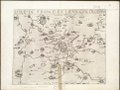 | 5,207 × 3,941 (58.74 MB) | Paris 16 | User created page with UploadWizard |
File usage
The following pages on the English Wikipedia use this file (pages on other projects are not listed):
Global file usage
The following other wikis use this file:
- Usage on uk.wikipedia.org