Original file (7,050 × 4,797 pixels, file size: 11.11 MB, MIME type: application/pdf)
| This is a file from the Wikimedia Commons. Information from its description page there is shown below. Commons is a freely licensed media file repository. You can help. |
Summary
| Description |
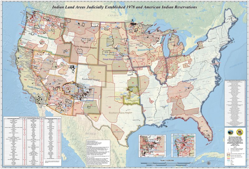
English: Indian Land Areas Judicially Established 1978 and American Indian Reservations
This map was created by the Bureau of Indian Affairs (BIA) Office of Trust Services (OTS) Division of Water and Power (DWP) and is currently retained and disseminated by the BIA Branch of Geospatial Support (BOGS) function, Lakewood, CO. Plot Date: July 2015 Data Sources: 1:10M Satellite-derived land cover data and shaded relief with ocean bottom data from NaturalEarthData.com 2015; American Indian Reservation data last updated in 2005 from US Census data and USGS 1:24,000 topographic maps; "ESRI Data and Maps" 2008; Oklahoma Tribal Statistical Area: Census Bureau (TIGER) data, Eastern Regional Office Natural Resources Department; Judicially Established Indian Land Area: USGS, 1993 (Original 1:4,000,000 scale; Albers projection). |
| Date | |
| Source | https://www.bia.gov/sites/bia_prod.opengov.ibmcloud.com/files/assets/public/pdf/Indian_Land_Areas_Judicially_Established_1978_and_AI_Reservations.pdf |
| Author | United States of America. Bureau of Indian Affairs. |
Licensing
This work is in the public domain in the United States because it is a work prepared by an officer or employee of the United States Government as part of that person’s official duties under the terms of Title 17, Chapter 1, Section 105 of the US Code.
Note: This only applies to original works of the Federal Government and not to the work of any individual U.S. state, territory, commonwealth, county, municipality, or any other subdivision. This template also does not apply to postage stamp designs published by the United States Postal Service since 1978. (See § 313.6(C)(1) of Compendium of U.S. Copyright Office Practices). It also does not apply to certain US coins; see The US Mint Terms of Use.
|
 | |
| This file has been identified as being free of known restrictions under copyright law, including all related and neighboring rights. | ||
File history
Click on a date/time to view the file as it appeared at that time.
| Date/Time | Thumbnail | Dimensions | User | Comment | |
|---|---|---|---|---|---|
| current | 17:13, 12 October 2021 |  | 7,050 × 4,797 (11.11 MB) | Carwil | Uploaded a work by United States of America. Bureau of Indian Affairs. from https://www.bia.gov/sites/bia_prod.opengov.ibmcloud.com/files/assets/public/pdf/Indian_Land_Areas_Judicially_Established_1978_and_AI_Reservations.pdf with UploadWizard |