Size of this preview: 404 × 600 pixels. Other resolutions: 161 × 240 pixels | 323 × 480 pixels | 517 × 768 pixels | 689 × 1,024 pixels | 1,311 × 1,947 pixels.
Original file (1,311 × 1,947 pixels, file size: 1.28 MB, MIME type: image/png)
| This is a file from the Wikimedia Commons. Information from its description page there is shown below. Commons is a freely licensed media file repository. You can help. |
Summary
| Description |
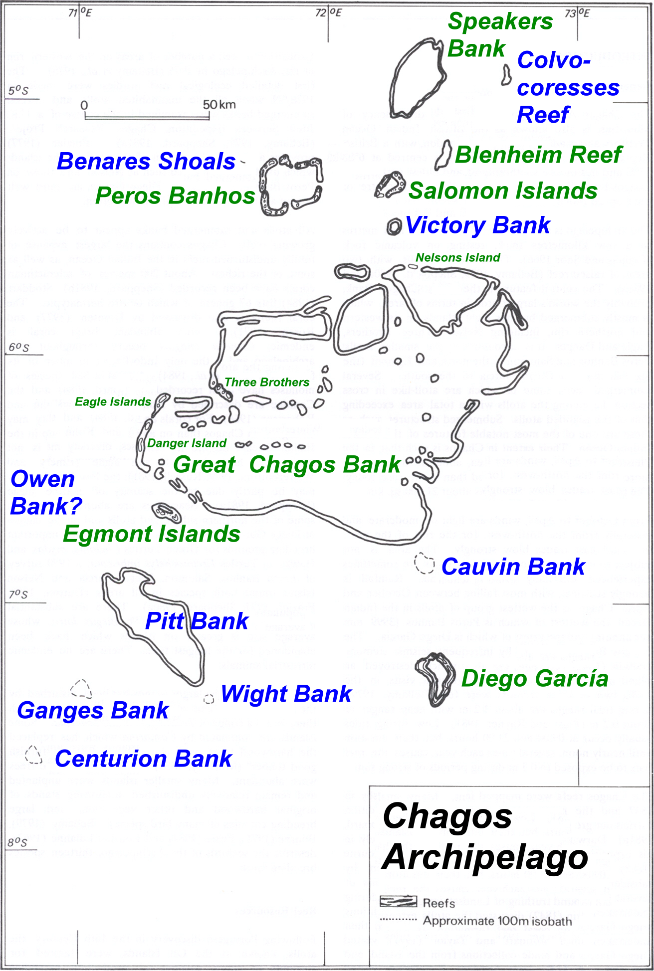
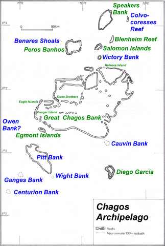
Deutsch: Karte des Chagos-Archipels im Indischen Ozean.
English: Map of Chagos-Archipelago in the Indian Ocean. |
| Date | not specified |
| Source | taken from http://www.coral.noaa.gov/Maps/chagos_large.jpg plus atoll and island names completed and rewritten |
| Author | NOAA, adapted by user Ratzer |
Licensing
This image is in the public domain because it contains materials that originally came from the U.S. National Oceanic and Atmospheric Administration, taken or made as part of an employee's official duties.
|
Original upload log
| date/time | username | Dimensions | File Size | edit summary |
|---|---|---|---|---|
| 11:01, 30 July 2006 | Ratzer | 1311×1947 | 1.28 MB | base map from http://www.coral.noaa.gov/reef_maps/volume2/chagos_large.jpg, plus atoll and island names completed and rewritten |
File history
Click on a date/time to view the file as it appeared at that time.
| Date/Time | Thumbnail | Dimensions | User | Comment | |
|---|---|---|---|---|---|
| current | 08:43, 14 March 2008 | | 1,311 × 1,947 (1.28 MB) | Telim tor | == Summary == {{Information |Description=Map of Chagos-Archipelago in the Indian Ocean. |Source=taken from http://www.coral.noaa.gov/reef_maps/volume2/chagos_large.jpg plus atoll and island names completed and rewritten |Date= |Author=NOAA |Permission= |o |
File usage
The following pages on the English Wikipedia use this file (pages on other projects are not listed):
Global file usage
The following other wikis use this file:
- Usage on af.wikipedia.org
- Usage on ar.wikipedia.org
- Usage on ast.wikipedia.org
- Usage on be-tarask.wikipedia.org
- Usage on ceb.wikipedia.org
- Usage on cs.wikipedia.org
- Usage on da.wikipedia.org
- Usage on de.wikipedia.org
- Usage on eo.wikipedia.org
- Usage on es.wikipedia.org
- Usage on fa.wikipedia.org
- Usage on fi.wikipedia.org
- Usage on fr.wikipedia.org
- Usage on gl.wikipedia.org
- Usage on io.wikipedia.org
- Usage on ja.wikipedia.org
- Usage on ka.wikipedia.org
- Usage on lt.wikipedia.org
- Usage on nl.wikipedia.org
- Usage on ro.wikipedia.org
- Usage on ru.wikipedia.org
- Usage on ta.wikipedia.org
- Usage on tr.wikipedia.org
- Usage on uk.wikipedia.org
- Usage on vi.wikipedia.org
- Usage on www.wikidata.org
- Usage on zh-yue.wikipedia.org