| Draft article not currently submitted for review.
This is a draft Articles for creation (AfC) submission. It is not currently pending review. While there are no deadlines, abandoned drafts may be deleted after six months. To edit the draft click on the "Edit" tab at the top of the window. To be accepted, a draft should:
It is strongly discouraged to write about yourself, your business or employer. If you do so, you must declare it. Where to get help
How to improve a draft
You can also browse Wikipedia:Featured articles and Wikipedia:Good articles to find examples of Wikipedia's best writing on topics similar to your proposed article. Improving your odds of a speedy review To improve your odds of a faster review, tag your draft with relevant WikiProject tags using the button below. This will let reviewers know a new draft has been submitted in their area of interest. For instance, if you wrote about a female astronomer, you would want to add the Biography, Astronomy, and Women scientists tags. Editor resources
Last edited by Dclemens1971 (talk | contribs) 1 second ago. (Update) |

.jpg)

The Geological Monument Type Location Maastrichtian is a geological monument in the South Limburg region of the Netherlands, located in the municipality of Maastricht. The monument is situated south of Maastricht and Sint Pieter, near the Meuse River, beneath the farmstead and Castle Ruin Lichtenberg. This castle ruin is perched atop a bare rock wall, largely remaining due to the excavation activities of the ENCI (Eerste Nederlandse Cement Industrie) in the ENCI quarry, which is part of the Sint-Pietersberg hill, itself a part of the Plateau of Caestert.
History
editIn 1798, Barthélemy Faujas de Saint-Fond described the "Histoire naturelle de la montagne de Saint-Pierre de Maestricht," detailing the natural history and fossils of the Sint-Pietersberg. This work became a standard reference and was translated into Dutch in 1802.[1][2]
In 1849, geologist André Hubert Dumont designated the limestone wall beneath the Lichtenberg farmstead as the type location for the Maastrichtian, the last age of the Late Cretaceous period. This designation has given the limestone wall international significance, attracting geologists from around the world to study it.[1][2]
In 1964, a scaffold was erected against the limestone wall to enable the sampling of the entire limestone profile.[2]
Geology
editAt the exposure beneath the Lichtenberg farmstead, the Gulpen Formation and the Maastricht Formation are visible. From top to bottom, the following layers are exposed at the type location:[2][1]
- Loess of the Schimmert Member from the Boxtel Formation (Weichselian, Pleistocene, Quaternary)
- Schimmert Member from the Beegden Formation (Cromerian, Pleistocene, Quaternary)
- Klimmen Member from the Tongeren Formation (Tongrian, Oligocene, Tertiary)
- Maastricht Formation (Maastrichtian, Upper Cretaceous)
- Meerssen Member
- Nekum Member
- Kanne Horizon
- Laumont Horizon
- Emael Member
- Lava Horizon
- Romontbos Horizon
- Schiepersberg Member
- Schiepersberg Horizon
- Gronsveld Member
- ENCI Horizon
- Sint Pieter Horizon
- Valkenburg Member
- Lichtenberg Horizon
- Gulpen Formation (Maastrichtian, Upper Cretaceous)
- Lanaye Member
- Nivelle Horizon
- Lixhe 3 Member
- Boirs Horizon
- Lixhe 2 Member
- Halembaye 2 Horizon
- Halembaye 1 Horizon
- Lixhe 1 Member
- Wahlwiller Horizon
- Vijlen Member
- Zonneberg Horizon
- Post-drilling:
- Bovenste Bosch Horizon
- Beutenaken Member
- Slenaken Horizon
- Zeven Wegen Member
- Zeven Wegen Horizon
- Lanaye Member
- Vaals Formation
- ...
- Raren Horizon
- ...
At the information board at the base of the limestone wall beneath Lichtenberg farmstead, the Gronsveld Member through the Lanaye Member are particularly well-exposed.[2]
See also
edit- List of geological monuments in South Limburg
- Lithostratigraphy of the Upper Cretaceous and Danian in South Limburg
-
 Information board for geological monument near the limestone wall. At the level of the wooden planks: ENCI Horizon. At the top edge of the upper entrance: Sint Pieter Horizon. Below the yellow beneath the upper entrance: Lichtenberg Horizon.
 -
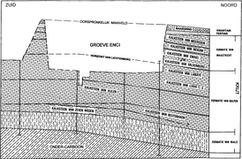 Geological cross-section of the ENCI quarry
 -
 Schematic profile through the ENCI quarry
 -
 Profile with drilling
.jpg)

.png)

References
edit- ^ a b c "Krijt van Zuid-Limburg," series "Geology of the Netherlands," W.M. Felder, P.W. Bosch, Netherlands Institute for Applied Geosciences TNO, 2000, ISBN 90-6743-710-7.
- ^ a b c d e "Geological monuments in South Limburg" (CD-ROM), P.W. Bosch, W.M. Felder, Netherlands Institute for Applied Geosciences TNO, 1999.
Bioclast Stratigraphy or Ecozonation for the Cretaceous (Santonian - Campanian - Maastrichtian) of South Limburg and Eastern Belgium (PDF), Sjeuf Felder, 2001
50°49′18.78″N 5°41′39.8″E / 50.8218833°N 5.694389°E