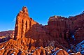
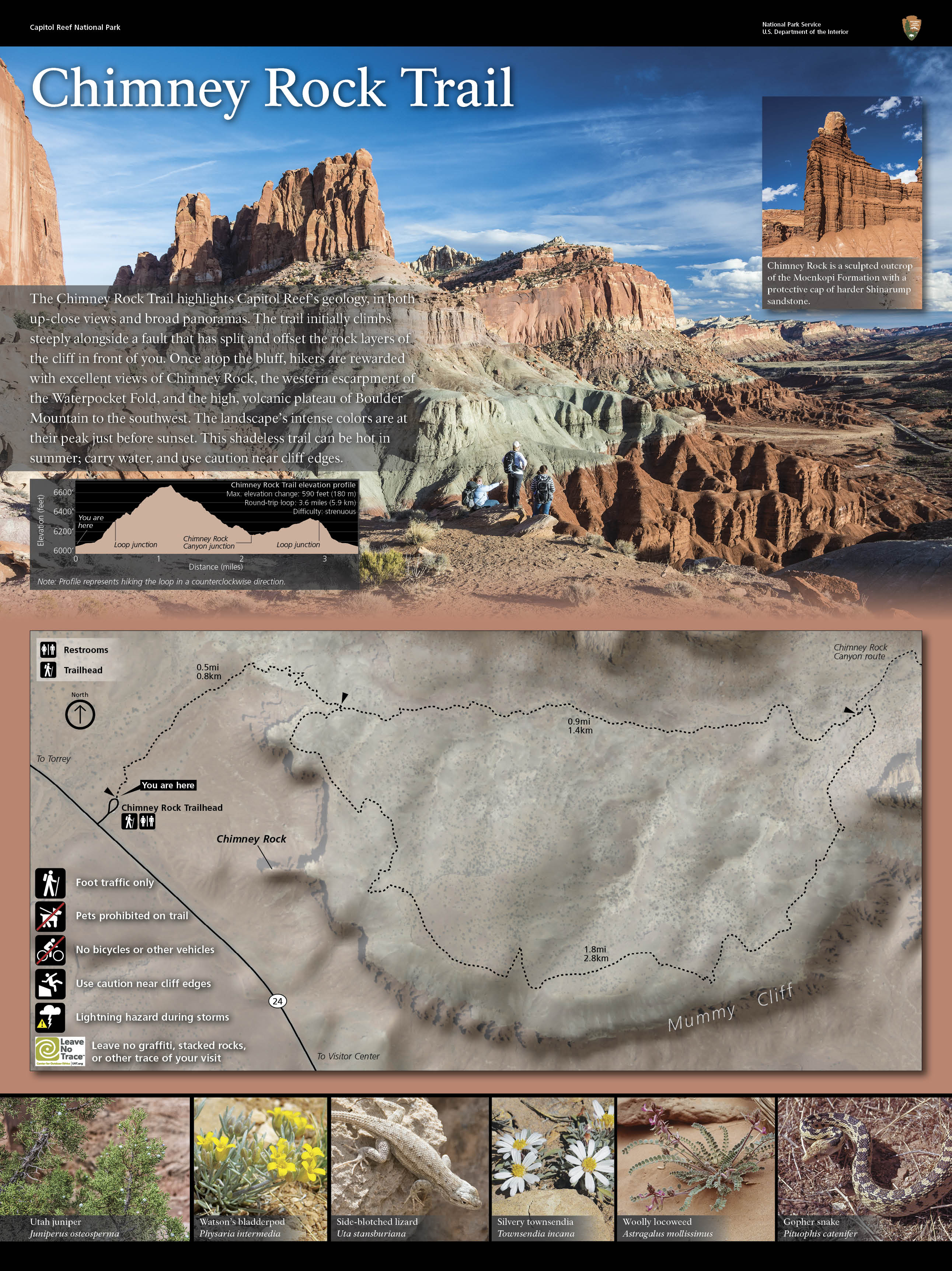
Chimney Rock is a 6,420-foot (1,960 m) summit in Capitol Reef National Park in Wayne County, Utah, United States.[2] This landmark is situated 2.5 mi (4.0 km) northwest of the park's visitor center, towering over 300 feet (91 m) above Utah State Route 24. Chimney Rock is also 2.5 mi (4.0 km) northwest of another of the park's landmarks, The Castle. Precipitation runoff from this feature ends up in the Colorado River drainage basin.[5] The Chimney Rock Trail is a 3.5-mile loop trail that takes hikers to a view of Chimney Rock from above Mummy Cliffs.
| Chimney Rock | |
|---|---|
 Chimney Rock, south-southwest aspect | |
| Highest point | |
| Elevation | 6,420 ft (1,960 m)[1] |
| Prominence | 80 ft (24 m)[1] |
| Parent peak | Mummy Cliff[1] |
| Isolation | 0.34 mi (0.55 km)[1] |
| Coordinates | 38°18′51″N 111°18′00″W / 38.3142290°N 111.2999938°W[2] |
| Geography | |
 Chimney Rock Location in Utah  Chimney Rock Chimney Rock (the United States) | |
| Location | Capitol Reef National Park Wayne County, Utah, US |
| Parent range | Colorado Plateau |
| Topo map | USGS Twin Rocks |
| Geology | |
| Age of rock | Triassic |
| Climbing | |
| Easiest route | closed to climbing[3][4] |
Geology edit
This feature is an erosional remnant composed of red sandstone of the Moenkopi Formation, topped with a Shinarump Conglomerate caprock of the Chinle Formation.[6] The Moenkopi Formation dates to about 245 million years ago, having formed during the Triassic. Long after the sedimentary rocks were deposited, the Colorado Plateau was uplifted relatively evenly, keeping the layers roughly horizontal, but Capitol Reef is an exception because of the Waterpocket Fold, a classic monocline, which formed between 50 and 70 million years ago during the Laramide Orogeny.[7]
Gallery edit
-
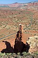
 South aspect
 -
 North aspect
 -
-
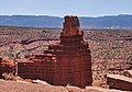
 Looking WNW at Chimney Rock, Hwy 24, and trailhead
 -
-
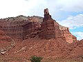 From west


Climate edit
Spring and fall are the most favorable seasons to visit Chimney Rock. According to the Köppen climate classification system, it is located in a Cold semi-arid climate zone, which is defined by the coldest month having an average mean temperature below 32 °F (0 °C), and at least 50% of the total annual precipitation being received during the spring and summer. This desert climate receives less than 10 inches (250 millimeters) of annual rainfall, and snowfall is generally light during the winter.
| Climate data for Capitol Reef Visitor Center, elevation 5,653 ft (1,723 m), 1981-2010 normals, extremes 1981-2019 | |||||||||||||
|---|---|---|---|---|---|---|---|---|---|---|---|---|---|
| Month | Jan | Feb | Mar | Apr | May | Jun | Jul | Aug | Sep | Oct | Nov | Dec | Year |
| Record high °F (°C) | 58.6 (14.8) |
68.3 (20.2) |
78.3 (25.7) |
84.4 (29.1) |
94.6 (34.8) |
100.2 (37.9) |
100.8 (38.2) |
97.9 (36.6) |
95.4 (35.2) |
86.1 (30.1) |
70.4 (21.3) |
61.5 (16.4) |
100.8 (38.2) |
| Mean daily maximum °F (°C) | 40.6 (4.8) |
46.4 (8.0) |
54.7 (12.6) |
65.0 (18.3) |
74.5 (23.6) |
85.3 (29.6) |
90.4 (32.4) |
87.9 (31.1) |
80.2 (26.8) |
66.1 (18.9) |
51.3 (10.7) |
40.6 (4.8) |
65.3 (18.5) |
| Mean daily minimum °F (°C) | 17.8 (−7.9) |
22.7 (−5.2) |
30.2 (−1.0) |
36.2 (2.3) |
44.7 (7.1) |
53.1 (11.7) |
60.4 (15.8) |
58.5 (14.7) |
50.4 (10.2) |
39.0 (3.9) |
27.6 (−2.4) |
18.2 (−7.7) |
38.3 (3.5) |
| Record low °F (°C) | −4.2 (−20.1) |
−11.8 (−24.3) |
9.1 (−12.7) |
18.1 (−7.7) |
27.2 (−2.7) |
34.6 (1.4) |
42.4 (5.8) |
45.1 (7.3) |
29.9 (−1.2) |
11.7 (−11.3) |
8.0 (−13.3) |
−7.5 (−21.9) |
−11.8 (−24.3) |
| Average precipitation inches (mm) | 0.52 (13) |
0.34 (8.6) |
0.53 (13) |
0.47 (12) |
0.59 (15) |
0.47 (12) |
0.91 (23) |
1.20 (30) |
0.80 (20) |
0.98 (25) |
0.49 (12) |
0.32 (8.1) |
7.62 (194) |
| Average dew point °F (°C) | 17.3 (−8.2) |
20.8 (−6.2) |
23.0 (−5.0) |
24.5 (−4.2) |
29.1 (−1.6) |
32.0 (0.0) |
40.0 (4.4) |
41.8 (5.4) |
34.8 (1.6) |
28.2 (−2.1) |
21.9 (−5.6) |
17.5 (−8.1) |
27.6 (−2.4) |
| Source: PRISM[8] | |||||||||||||
See also edit
References edit
- ^ a b c d "Chimney Rock - 6,420' UT". listsofjohn.com. Retrieved 2020-09-26.
- ^ a b U.S. Geological Survey Geographic Names Information System: Chimney Rock
- ^ Caitol Reef Rock Climbing, Utah.com
- ^ Capitol Reef Rock Climbing and Bouldering, nps.gov
- ^ "Chimney Rock, Utah". Peakbagger.com.
- ^ Rick Stinchfield, Capitol Reef National Park The Complete Hiking and Touring Guide, Westcliffe Publishers, 2010.
- ^ Capitol Reef Geology, NPS.gov
- ^ "PRISM Climate Group, Oregon State University". Retrieved February 19, 2019.
External links edit
- Capitol Reef National Park National Park Service
- Chimney Rock Trail: National Park Service