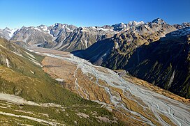
The Butler Range is a range located in the Ashburton District of Canterbury on the South Island of New Zealand.[1] To the south of the range is the Rakaia River. The area was first farmed by Samuel Butler, who called his holding Mesopotamia Station. The highest peak of Butler Range is Lauper Peak at 2,485 metres (8,153 ft), named after the Swiss-born explorer Jakob Lauper.[2] Mount Butler (2,103 metres or 6,900 feet) is located further south in the Butler Range and is also named after Samuel Butler.[3]
| Butler Range | |
|---|---|
 Butler Range (top centre) to the right of the Rakaia River | |
| Highest point | |
| Elevation | 2,485 m (8,153 ft) |
| Geography | |
 | |
| Country | New Zealand |
| Region | Canterbury |
| Range coordinates | 43°14′13″S 170°55′59″E / 43.237°S 170.933°E |
References
edit- ^ "Place name detail: Butler Range". New Zealand Gazetteer. New Zealand Geographic Board. Retrieved 22 February 2021.
- ^ "Place name detail: Lauper Peak". New Zealand Gazetteer. New Zealand Geographic Board. Retrieved 22 February 2021.
- ^ "Place name detail: Mount Butler". New Zealand Gazetteer. New Zealand Geographic Board. Retrieved 22 February 2021.
External links
edit