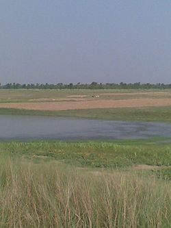
The Burhi Gandak River is a tributary of the Ganges. It is also known as the Sikrahna river.[2] The Burhi (“Old”) Gandak flows parallel to and east of the Gandak River in an old channel.[3][4]
| Burhi Gandak River | |
|---|---|
 | |
 | |
| Location | |
| Country | India[1] |
| State | Bihar[1] |
| Physical characteristics | |
| Source | Chautarwa Chaur |
| • location | near Harpur , West Champaran district[1] |
| Mouth | Ganges |
• location | Khagaria |
• coordinates | 25°26′02″N 86°36′25″E / 25.43389°N 86.60694°E |
| Length | 320 km (200 mi) |
| Basin size | 10,150 km2 (3,920 sq mi) |
| Discharge | |
| • location | Between Gogri Khagariya and Bariarpur Munger |
Course
editThe Burhi Gandak originates from Chautarwa Chaur near Bisambharpur in the district of West Champaran in Bihar.[1] It initially flows through the East Champaran district. After flowing for a distance of about 56 kilometres (35 mi), the river takes a southerly turn where two rivers - the Dubhara and the Tour – join it. Thereafter, the river flows in a south-easterly direction through the Muzaffarpur district for about 32 kilometres (20 mi). In this portion, the river spills over its banks and a number of spill channels take off and rejoin it later.[3]
The Burhi Gandak runs a zig-zag course through the districts of Samastipur and Begusarai before covering a short distance in Khagaria district, running by the side of the town of Khagaria, and flows into the Ganges near Gogri and near Bairarpur in Munger . It forms the western boundary of the Khagaria town and a protection embankment built along the eastern side of this river, protects Khagaria town from the floods of Burhi Gandak.[5][6][7]
The total length of the river is 320 kilometres (200 mi). The drainage area of the river is 10,150 square kilometres (3,920 sq mi).[3]
Tributaries
editThe main tributaries of the Burhi Gandak are - Masan, Balor, Pandai, Sikta, Tilawe, Tiur, Dhanauti, Kohra, Anjankote, Danda and lauriya , .[1]
References
edit- ^ a b c d e "RIVER BASIN". Flood Management Information System, Water Resource Department, Bihar. Retrieved 2010-05-05.
- ^ "With Burhi Gandak Flooded, Champaran's Villagers Are Demolishing Their Own Homes to Save Construction Material". The Weather Channel. Retrieved 2024-03-21.
- ^ a b c Jain, Sharad K.; Agarwal, Pushpendra K.; Singh, Vijay P. (16 May 2007). Hydrology and Water Resources of India By Sharad K. Jain, Pushpendra K. Agarwal, Vijay P. Singh. Springer. ISBN 9781402051807. Retrieved 2010-05-05.
{{cite book}}:|work=ignored (help) - ^ Burhi Gandak. Britannica. Retrieved 2010-05-05.
- ^ "Samastipur district". District administration. Retrieved 2010-05-05.
- ^ "Begusarai district". District administration. Retrieved 2010-05-05.
- ^ "Khagaria district". River system. District administration. Retrieved 2010-05-05.