The Book of Roads and Kingdoms (Arabic: كتاب المسالك والممالك, Kitāb al-Masālik waʿl-Mamālik[1]) is a group of Islamic manuscripts composed from the Middle Ages to the early modern period.[2] They emerged from the administrative tradition of listing pilgrim and post stages.[3][4] Their text covers the cities, roads, topography, and peoples of the Muslim world, interspersed with personal anecdotes.[5] A theoretical explanation of the "Inhabited Quarter" of the world, comparable to the ecumene, frames the world with classical concepts like the seven climes.[6][3]

The books include illustrations so geometric that they are barely recognizable as maps.[7] These schematic maps do not attempt a mimetic depiction of physical boundaries.[8][9] With little change in design, the treatises typically offer twenty regional maps and a disc-shaped map of the world surrounded by the Encircling Ocean.[6] The maps have a flat quality, but the textual component implies a spherical Earth. Andalusi scholar Abi Bakr Zuhri explained, "Their objective is the depiction of the earth, even if it does not correspond to reality. Because the earth is spherical but the [map] is simple".[10]
The first, incomplete Kitāb al-Masālik wa'l-Mamālik by Ja‘far ibn Ahmad al-Marwazi is now lost.[11] The earliest surviving version was written by Ibn Khordadbeh circa 870 CE,[11] during the reigns of Abbasid caliphs al-Wathiq and al-Mu'tamid.[11] The earliest known version of the idiosyncratic cartography was composed by al-Istakhri circa 950 CE,[12] although only copies by later artists survive.[13] As he was a follower of Abu Zayd al-Balkhi,[6] this style of map-making is often referred to as the "Balkhī school",[14] or the "Classical School". Leiden University Libraries holds مختصر كتاب المسالك والممالك لابي اسحاق ابراهيم بن محمد الاصطخري / World map in a summary of Kitab al-masalik wa’l mamalik, MS Or. 3101, 1193. [15] The maps are sometimes called the "Atlas of Islam",[6] or abbreviated as KMMS maps.[9] This tradition of mapping appears in related works including Ibn Hawqal's Ṣūrat al-’Arḍ (صورة الارض; "The face of the Earth").[16]
Gallery edit
-
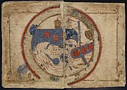 Istakhri's world map (South at top, copy dated to 1193) Leiden University Libraries
 -
 Ibn Hawqal's world map (South at top, copy dated to the 14th century)
 -
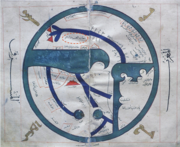
 Ibn Hawqal's world map translated into English
 -
 Map of the Persian Gulf from the Kitab al-Masalik wa'l-Mamalik by al-Istakhri (restored in 2018, Persian translation dated to the 14-15th century CE)
 -
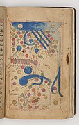 Map of Pars by al-Istakhri from folio 40b of the Khalili Collection of Islamic Art MSS 972 (dated to c. 1306 CE)
 -
 Istakhri's map of the Mediterranean, with Fraxinetum depicted as an island (West at top, copy dated to 1173)


.jpg)


See also edit
Notes edit
- ^ Also translated "Highways and Kingdoms", "Routes and Kingdoms", "Routes and Countries", "Routes and Realms", etc.
- ^ Pinto 2004, pp. 128–130.
- ^ a b Pinto 2016, p. 55.
- ^ Jafri 2019.
- ^ Pinto 2004, p. 130.
- ^ a b c d Meri & Bacharach 2005, p. 286.
- ^ Pinto 2016, p. 1.
- ^ Casale 2019, p. 866.
- ^ a b Pinto 2016, p. 33.
- ^ Pinto 2016, ch. 3.
- ^ a b c Meri & Bacharach 2005, p. 360.
- ^ Meri & Bacharach 2005, pp. 139, 285.
- ^ Pinto 2004, p. 131.
- ^ Edson & Savage-Smith 2004, pp. 61–63.
- ^ "Digital version of An abridgement of Kitāb al-masālik wa-al-mamālik by Abū Isḥāq Ibrāhīm b. Muḥammad al-Iṣṭaḵrī - Or. 3101". Leiden University Libraries. Retrieved 2024-04-10.
- ^ Şeşen 1999.
References edit
- Casale, Giancarlo (2019). "Did Alexander the Great Discover America? Debating Space and Time in Renaissance Istanbul". Renaissance Quarterly. 72 (3): 863–909. doi:10.1017/rqx.2019.252. ISSN 0034-4338. JSTOR 26845906. S2CID 204482631. Accessed 2023-05-27.
- Edson, Evelyn; Savage-Smith, Emilie (2004). Medieval Views of the Cosmos. University of Oxford. ISBN 978-1851241842.
- Jafri, Ayfer S., ed. (2019). "Geography". Cities of Light. Georgetown University – via Unity Productions Foundation, Inc.
- Meri, Josef W.; Bacharach, Jere (2005). Medieval Islamic Civilization: An Encyclopedia. Routledge. ISBN 0-415-96690-6.
- Pinto, Karen (2004). "Cartography and Geography". In Martin, Richard C.; Arjomand, Saïd Amir; Hermansen, Marcia; Tayob, Abdulkader; Rochelle, Davis (eds.). Encyclopedia of Islam and the Muslim World. Vol. 1. New York: Macmillan USA. pp. 128–132.
- Pinto, Karen (2016). Medieval Islamic Maps: An Exploration. Chicago & London: The University of Chicago Press.
- Şeşen, Ramzan (1999). "IBN HAVKAL". TDV Encyclopedia of Islam (in Turkish). Vol. 20 (Ibn Haldun – Ibnu'l Cezeri). pp. 34–35. ISBN 9789753894470.