Bogen (Norwegian) or Ránda (Northern Sami)[3] is the administrative centre of Evenes Municipality in Nordland county, Norway. The village is located along the shore of the Ofotfjorden, about 10 kilometres (6.2 mi) northeast of the village of Liland. The European route E10 highway passes through the village. Bogen Chapel is located in this village.[4]
Village | |
 View of the village (looking south) | |
 Bogen Location in Nordland  Bogen Bogen (Norway) | |
| Coordinates: 68°31′35″N 16°59′36″E / 68.5263°N 16.9933°E | |
| Country | Norway |
| Region | Northern Norway |
| County | Nordland |
| District | Ofoten |
| Municipality | Evenes |
| Area | |
| • Total | 0.55 km2 (0.21 sq mi) |
| Elevation | 10 m (30 ft) |
| Population (2018)[1] | |
| • Total | 395 |
| • Density | 718/km2 (1,860/sq mi) |
| Time zone | UTC+01:00 (CET) |
| • Summer (DST) | UTC+02:00 (CEST) |
| Post Code | 8533 Bogen i Ofoten |
The 0.55-square-kilometre (140-acre) village has a population (2018) of 395 which gives the village a population density of 718 inhabitants per square kilometre (1,860/sq mi).[1]
Historically, Bogen is most notable for small-scale iron ore mining in the early 20th century as well as being a German naval base during World War II, including for the German battleship Tirpitz and the heavy cruiser Admiral Hipper.[4][5]
Media gallery edit
-
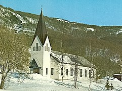 Bogen chapel, March 2008
 -
 Tirpitz, escorted by several destroyers, steaming in the Bogenfjord in October 1942
 -

-


.jpg)
.jpg)
References edit
- ^ a b c Statistisk sentralbyrå (1 January 2018). "Urban settlements. Population and area, by municipality".
- ^ "Bogen, Evenes (Nordland)". yr.no. Retrieved 2019-01-05.
- ^ "Stadnamn og skrivemåten for stadnamn" (in Norwegian). Kartverket. Retrieved 2019-01-05.
- ^ a b Store norske leksikon. "Bogen – i Evenes" (in Norwegian). Retrieved 2012-06-06.
- ^ Tromsø Museum. "Important years in mining history" (in Norwegian). Archived from the original on 2007-07-09.
{{cite journal}}: Cite journal requires|journal=(help)
This Nordland location article is a stub. You can help Wikipedia by expanding it. |