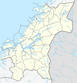
Bjørøya is an island in the Folda sea, just south of the Namsenfjorden in the municipality of Flatanger in Trøndelag county, Norway. The 3.8-square-kilometre (1.5 sq mi) island lies about 5 kilometres (3.1 mi) east of the island of Villa and about 5 kilometres (3.1 mi) north of the island of Lauvøya. The island has several large peat bogs as well as a farm. Ellingråsa Lighthouse is located on the northwest part of the island. The island has had no permanent residents since the 1970s.[1]
 | |
| Geography | |
|---|---|
| Location | Trøndelag, Norway |
| Coordinates | 64°34′25″N 10°49′16″E / 64.5735°N 10.8211°E |
| Area | 3.8 km2 (1.5 sq mi) |
| Length | 2.7 km (1.68 mi) |
| Width | 2.5 km (1.55 mi) |
| Highest elevation | 130 m (430 ft) |
| Highest point | Sørfjellet |
| Administration | |
Norway | |
| County | Trøndelag |
| Municipality | Flatanger |
| Demographics | |
| Population | 0 |
See also edit
References edit
- ^ Rosvold, Knut A., ed. (2011-12-18). "Bjørøya". Store norske leksikon (in Norwegian). Kunnskapsforlaget. Retrieved 2018-04-16.

