Bhaktapur District (Nepali: भक्तपुर जिल्ला; Nepal Bhasa : ख्वप देश (जिल्ला) located in the eastern part of Kathmandu valley, is the smallest among Nepal's 77 districts. It is part of Bagmati Province. Bhaktapur District Post Office is 44800. The district, with Bhaktapur as its district headquarters, covers an area of 119 km2 (46 sq mi) and in 2011 had a population of 304,651[3] of whom 9,701 people were absent (mostly working abroad).[4]
Bhaktapur District | |
|---|---|
 Kathmandu Valley, Bhaktapur District | |
| Nickname: Khwopa | |
 Location in Bagmati Province | |
| Coordinates: 27°40′20″N 85°25′40″E / 27.672222°N 85.427778°E | |
| Country | Nepal |
| Province | Bagmati Province |
| Headquarters | Bhaktapur |
| Area | |
| • Total | 119 km2 (46 sq mi) |
| Population | |
| • Total | 304,651 |
| • Density | 2,600/km2 (6,600/sq mi) |
| 2001 pop.: 225,461 1991 pop.: 172,952 1981 pop.: 159,767 | |
| Time zone | UTC+5:45 (NPT) |
| Area code | +977-1 |
Education
editThe average literacy rate of Bhaktapur is 81.68% (male 90.48%, female 72.65%), which is growing with educational awareness.[5]
The governmental schools in Bhaktapur are making remarkable improvements in their educational quality.[6] The government schools have been starting to facilitate students by teaching in both English and Nepali medium.
Despite topping other districts in SLC with the highest enrolments, the higher studies in Bhaktapur is not quite satisfactory. There are not enough colleges in Bhaktapur to render quality services. That's why students from Bhaktapur complete their higher studies in colleges in Kathmandu and Lalitpur. However, their academic performance at those colleges cannot be neglected. Khwopa College situated in Dekocha Bhaktapur is one of the top colleges in Nepal. The academic result of this college is outstanding. This college is established and managed by the Bhaktapur municipality.
Health care
editBhaktapur is growing aggressively on the health care services and facilities. Bhaktapur did not have enough hospitals and health care centers in the past, but now there are many public and private hospitals which provide quality medical service.
Bhaktapur district has two comprehensive cancer hospitals Bhaktapur Cancer Hospital,[7] and Kathmandu Cancer Center. Other major centers like National Tuberculosis Centre, Human Organ Transplant Center and Ayurvedic Centre is located in Bhaktapur. Other major hospitals are Khwopa Hospital, Bhaktapur Hospital, Siddhi Memorial Hospital (For Women & Children), Iwamura Memorial Hospital, Madhyapur Hospital, Nagarik Community Hospital, Nepal Korea friendship hospital. Recently, the Government of Nepal has decided to transfer Bir hospital, the oldest hospital in Nepal, to Duwakot, Bhaktapur.
Geography and climate
edit| Climate Zone[8] | Elevation Range | % of Area |
|---|---|---|
| Subtropical | 1,000 to 2,000 meters 3,300 to 6,600 ft. |
99.4% |
| Temperate | 2,000 to 3,000 meters 6,400 to 9,800 ft. |
0.6% |
Demographics
edit| Census year | Pop. | ±% p.a. | |
|---|---|---|---|
| 1981 | 159,767 | — | |
| 1991 | 172,952 | +0.80% | |
| 2001 | 225,461 | +2.69% | |
| 2011 | 304,651 | +3.06% | |
| 2021 | 430,408 | +3.52% | |
| |||
| Source: Citypopulation[9] | |||
At the time of the 2011 Nepal census, Bhaktapur District had a population of 304,651.
language in Bhaktapur District
As their first language, 45.9% spoke Nepali, 42.3% Newar, 7.9% Tamang, 1.1% Maithili, 0.5% Magar, 0.4% Bhojpuri, 0.4% Rai, 0.2% Hindi, 0.2% Limbu, 0.2% Tharu, 0.1% Chamling, 0.1% Doteli, 0.1% Gurung, 0.1% Sherpa, 0.1% Sunuwar, 0.1% Urdu and 0.2% other languages.[10]
Ethnicity/caste: 46.3% were Newar, 19.6% Chhetri, 14.2% Hill Brahmin, 9.0% Tamang, 2.2% Magar, 1.1% Rai, 1.0% Sanyasi/Dasnami, 0.6% Kami, 0.5% Damai/Dholi, 0.5% Gurung, 0.5% Musalman, 0.5% Sarki, 0.5% Tharu, 0.4% other Dalit, 0.4% Limbu, 0.4% Thakuri, 0.3% Gharti/Bhujel, 0.2% Majhi, 0.2% other Terai, 0.2% Yadav, 0.1% Badi, 0.1% Terai Brahmin, 0.1% Hajam/Thakur, 0.1% Koiri/Kushwaha, 0.1% Sherpa, 0.1% Sudhi, 0.1% Teli and 0.2% others.[11]
Religion: 87.9% were Hindu, 9.2% Buddhist, 2.0% Christian, 0.5% Muslim, 0.4% Kirati and 0.1% others.[13]
Literacy: 81.3% could read and write, 1.8% could only read and 16.9% could neither read nor write.[14]
Municipalities
editThe district is divided into four municipalities:
Places of interest
editGallery
edit-
 Bhairavnath Temple, Bhaktapur Durbar Square
 -
 Taumadhi Square, Bhaktapur Durbar Square
 -
 Dattatreya Temple, Bhaktapur Durbar Square
 -
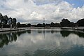 Siddha Pokhari
 -
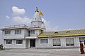 Pilot Baba Ashram, Gunduriya


,_built_during_the_reign_of_King_Yakshya_Malla_in_the_early_15th_century,_Bhaktapur.jpg)

See also
editReferences
edit- ^ "National Planning Commission Secretariat, Central Bureau of Statistics. Nepal". Archived from the original on 16 August 2016.
- ^ "Statistical Year Book of Nepal – 2011" (PDF). Archived from the original (PDF) on 26 March 2016. Retrieved 6 September 2016.
- ^ "National Population and Housing Census 2011(National Report)" (PDF). Central Bureau of Statistics. Government of Nepal. November 2012. Archived from the original (PDF) on 18 April 2013. Retrieved 1 November 2012.
- ^ http://census.gov.np/images/pdf/Preliminary%20Leaflet%202011.pdf[permanent dead link]
- ^ "Census Nepal 2011". Census Nepal 2011. Retrieved 14 May 2022.
- ^ "District Education Office, Bhaktapur".
- ^ "Bhaktapur Cancer hospital". ncrs.org.np.
- ^ The Map of Potential Vegetation of Nepal – a forestry/agroecological/biodiversity classification system (PDF), . Forest & Landscape Development and Environment Series 2-2005 and CFC-TIS Document Series No.110., 2005, ISBN 87-7903-210-9, retrieved 22 November 2013
- ^ "NEPAL: Administrative Division". www.citypopulation.de.
- ^ NepalMap Language [1]
- ^ NepalMap Caste [2]
- ^ "NepalMap profile: Bhaktapur". NepalMap. Retrieved 16 July 2022.
- ^ NepalMap Religion [3]
- ^ NepalMap Literacy [4]
External links
edit- "Districts of Nepal". Statoids.