Bansang is a town in the Central River Division of the Gambia, with a population of 8,843 (2012). Although the official government center of the Division is located in Janjanbureh downstream, Bansang has better access to the more affluent coastal region of the country, and is sometimes considered the unofficial "upcountry" economic capital.[dubious ]
Bansang | |
|---|---|
 | |
 Bansang Location in the Gambia | |
| Coordinates: 13°26′N 14°39′W / 13.433°N 14.650°W | |
| Country | The Gambia |
| Division | Central River Division |
| District | Fulladu West |
| Population (2012) | |
| • Total | 8,843 |
| Time zone | UTC+0 (GMT) |
The town is a market for peanuts, rice and fish.[1]
History edit
The area was originally part of the kingdoms of Jimara and Wuropana, constituent states of the Kaabu empire. In the 1860s the Fula kingdom of Fuladu rose as Kaabu declined.
Bansang became an important settlement during the colonial period as families settled there to take advantage of opportunities in the growing trade of peanuts on the Gambia river. Mandinka people were the earliest founders, followed by Fula and Wolof in the 20th century.[2] The village began as a seasonally inhabited trading post, until the first compound was founded by a prosperous local trader, Bakary Darboe, in the 1920s. His family was followed by relatives of Musa Molloh Balde, ruler of Fuladu.[3]
Gallery edit
-
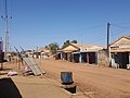 The main street in Bansang
 -
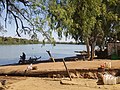 Upstream view of the River Gambia
 -
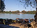 The manually-operated vehicle ferry across the river


Sources edit
13°26′N 14°39′W / 13.433°N 14.650°W
References edit
- ^ Bansang, Encyclopædia Britannica online. Retrieved 2012-04-30.
- ^ Bellagamba, Alice. "A Matter of Trust. Political Identities and Interpersonal Relationships along the River Gambia." Paideuma, vol. 46, 2000, p. 38. JSTOR, http://www.jstor.org/stable/40341782. Accessed 4 June 2023.
- ^ Bellagamba, 47-8.
This Gambian location article is a stub. You can help Wikipedia by expanding it. |