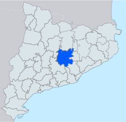
Bages (Catalan pronunciation: [ˈbaʒəs]) is a comarca (county) in the central region of Catalonia, Spain. The capital is the city of Manresa.
Bages | |
|---|---|
 | |
| Country | |
| Autonomous community | |
| Province | |
| Region | Central Catalonia |
| Capital | Manresa |
| Municipalities | List
|
| Government | |
| • Body | Bages Comarcal Council |
| • President | Eloi Hernàndez (ERC) |
| Area | |
| • Total | 1,092.2 km2 (421.7 sq mi) |
| Population (2014) | |
| • Total | 175,527 |
| • Density | 160/km2 (420/sq mi) |
| adjusted following Moianès creation | |
| Demonym | |
| Time zone | UTC+1 (CET) |
| • Summer (DST) | UTC+2 (CEST) |
| Largest municipality | Manresa |
Industries include the mining of potash at Súria and Sallent, and the manufacture of textiles along the rivers Llobregat and Cardener. Agriculture includes vineyards, cereals, and olive groves.
To the north are Berguedà and (running clockwise) Lluçanès, Moianès, and Vallès Occidental. To the south are Baix Llobregat, Anoia and Solsonès. In May 2015, Bages lost five municipalities - Calders, L'Estany, Moià, Monistrol de Calders, Santa Maria d'Oló - to the new comarca of Moianès.[1]
Municipalities
edit| Municipality | Population(2014)[2] | Areakm2[2] |
|---|---|---|
| Aguilar de Segarra | 251 | 43.3 |
| Artés | 5,661 | 17.9 |
| Avinyó | 2,275 | 63.2 |
| Balsareny | 3,343 | 36.9 |
| Callús | 1,985 | 12.5 |
| Cardona | 4,921 | 66.7 |
| Castellbell i el Vilar | 3,624 | 28.5 |
| Castellfollit del Boix | 428 | 58.9 |
| Castellgalí | 2,022 | 17.2 |
| Castellnou de Bages | 1,241 | 29.2 |
| Fonollosa | 1,429 | 51.7 |
| Gaià | 163 | 39.5 |
| Manresa | 75,297 | 41.6 |
| Marganell | 297 | 13.5 |
| Monistrol de Montserrat | 2,945 | 11.8 |
| Mura | 211 | 47.8 |
| Navarcles | 6,003 | 5.5 |
| Navàs | 6,117 | 80.6 |
| El Pont de Vilomara i Rocafort | 3,780 | 27.4 |
| Rajadell | 528 | 45.5 |
| Sallent | 6,780 | 65.2 |
| Sant Feliu Sasserra | 626 | 22.4 |
| Sant Fruitós de Bages | 8,243 | 22.2 |
| Sant Joan de Vilatorrada | 10,733 | 16.4 |
| Sant Mateu de Bages | 644 | 102.9 |
| Sant Salvador de Guardiola | 3,130 | 37.2 |
| Sant Vicenç de Castellet | 9,326 | 17.1 |
| Santpedor | 7,384 | 16.6 |
| Súria | 5,999 | 23.6 |
| Talamanca | 141 | 29.4 |
| • Total: 30 | 175,527 | 1,092.2 |
References
edit- ^ "El Parlament aprova la llei de creació del Moianès amb els vots en contra de Ciutadans i l'abstenció del PP" (in Catalan). La Vanguardia. 2015-04-15. Retrieved 2015-04-15.
- ^ a b "El municipi en xifres". Institut d'Estadística de Catalunya. Retrieved 2015-05-25.