Bělá nad Radbuzou (German: Weißensulz) is a town in Domažlice District in the Plzeň Region of the Czech Republic. It has about 1,700 inhabitants.
Bělá nad Radbuzou | |
|---|---|
 Bridge over the Bezděkovský Stream and the town square | |
 Flag  Coat of arms | |
 Bělá nad Radbuzou Location in the Czech Republic | |
| Coordinates: 49°35′36″N 12°42′48″E / 49.59333°N 12.71333°E | |
| Country | |
| Region | Plzeň |
| District | Domažlice |
| First mentioned | 1121 |
| Government | |
| • Mayor | Libor Picka |
| Area | |
| • Total | 83.32 km2 (32.17 sq mi) |
| Elevation | 442 m (1,450 ft) |
| Population (2023-01-01)[1] | |
| • Total | 1,718 |
| • Density | 21/km2 (53/sq mi) |
| Time zone | UTC+1 (CET) |
| • Summer (DST) | UTC+2 (CEST) |
| Postal codes | 345 25, 345 26 |
| Website | www |
Administrative parts edit
Villages of Bystřice, Čečín, Černá Hora, Doubravka, Hleďsebe, Karlova Huť, Nový Dvůr, Pleš, Smolov, Újezd Svatého Kříže and Železná are administrative parts of Bělá nad Radbuzou.
Etymology edit
Bělá nad Radbuzou got its name probably from the river Radbuza, which was called here Bílý potok ("White Creek").[2]
Geography edit

Bělá nad Radbuzou is located about 9 kilometres (6 mi) north of Domažlice and 37 km (23 mi) southwest of Plzeň. The town is situated at the confluence of the Radbuza River and the Bezděkovský Stream. The built-up area lies in the Upper Palatine Forest Foothills, but most of the municipal territory lies in the Upper Palatine Forest and borders Germany in the west.
History edit
The first written mention of Bělá nad Radbuzou is from 1121, when the near Přimda Castle was built. Until 1600, Bělá nad Radbuzou was a part of the Přimda estate.[2] In the 16th century, it became a property of Lamminger of Albenreuth, a Bavarian noble family. In 1614 the Lamminger family built a small Renaissance castle and a brewery. After the Battle of White Mountain, in 1623, the estate was merged with Újezd Svatého Kříže and the castle ceased to serve as the seat of the estate. In 2014, the castle burned down.[3]
Demographics edit
|
|
| ||||||||||||||||||||||||||||||||||||||||||||||||||||||
| Source: Censuses[4][5] | ||||||||||||||||||||||||||||||||||||||||||||||||||||||||
Transport edit
Bělá nad Radbuzou lies on the railway line heading from Domažlice to Planá.[6]
Sights edit

The Church of Our Lady of Sorrows is a landmark of the town centre. It was built in 1721 on the site of a chapel from the late 17th century. The church was completely rebuilt into its current Neoclassical form in 1826–1846.[7]
A cultural monument is the stone bridge over the Bezděkovský Stream from 1820.[8]
Notable people edit
- Jan Smudek (1915–1999), resistance fighter
- Hans Drachsler (1916–1996), German politician
Twin towns – sister cities edit
Bělá nad Radbuzou is twinned with:[9]
 Eslarn, Germany
 Hindelbank, Switzerland
Gallery edit
-
 Stone bridge over the Radbuza
 -
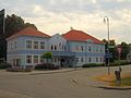 Town hall


References edit
- ^ "Population of Municipalities – 1 January 2023". Czech Statistical Office. 2023-05-23.
- ^ a b "Historie" (in Czech). Město Bělá nad Radbuzou. Retrieved 2021-06-13.
- ^ "Zámek Bělá nad Radbuzou" (in Czech). Hrady.cz. Retrieved 2021-06-13.
- ^ "Historický lexikon obcí České republiky 1869–2011 – Okres Domažlice" (in Czech). Czech Statistical Office. 2015-12-21. pp. 1–2.
- ^ "Population Census 2021: Population by sex". Public Database. Czech Statistical Office. 2021-03-27.
- ^ "Detail stanice Bělá nad Radbuzou" (in Czech). České dráhy. Retrieved 2023-06-30.
- ^ "Kostel Panny Marie Bolestné" (in Czech). National Heritage Institute. Retrieved 2023-02-17.
- ^ "Silniční most" (in Czech). National Heritage Institute. Retrieved 2023-02-17.
- ^ "Základní údaje" (in Czech). Město Bělá nad Radbuzou. Retrieved 2020-08-05.