Aquitania is a town and municipality in Boyacá Department, Colombia, part of the Sugamuxi Province, a subregion of Boyaca. Aquitania borders Sogamoso, Cuítiva and Mongua in the north, Zetaquirá, San Eduardo and Páez in the south, Labranzagrande, Pajarito, Recetor and Chámeza in the east and Cuítiva, Tota, Zetaquirá and San Eduardo in the west. The urban centre is situated on the Altiplano Cundiboyacense as one of the highest towns at an altitude of 3,030 metres (9,940 ft). The town of Aquitania borders Lake Tota to the east.[1]
Aquitania | |
|---|---|
Municipality and town | |
 Central square | |
 Flag .svg) Seal | |
 Location of the municipality and town of Aquitania in the Boyacá Department of Colombia | |
| Country | |
| Department | Boyacá Department |
| Province | Sugamuxi Province |
| Founded | 1777 |
| Government | |
| • Mayor | Hector Orlando Barrera Cardenas (2020-2023) |
| Area | |
| • Municipality and town | 943 km2 (364 sq mi) |
| • Urban | 0.52 km2 (0.20 sq mi) |
| Elevation | 3,030 m (9,940 ft) |
| Population (2015) | |
| • Municipality and town | 15,241 |
| • Density | 16/km2 (42/sq mi) |
| • Urban | 6,329 |
| Time zone | UTC-5 (Colombia Standard Time) |
| Website | Official website |

Climate
edit| Climate data for Aquitania/Lake Tota (Tunel El), elevation 3,000 m (9,800 ft), (1981–2010) | |||||||||||||
|---|---|---|---|---|---|---|---|---|---|---|---|---|---|
| Month | Jan | Feb | Mar | Apr | May | Jun | Jul | Aug | Sep | Oct | Nov | Dec | Year |
| Mean daily maximum °C (°F) | 16.9 (62.4) |
16.8 (62.2) |
17.0 (62.6) |
16.3 (61.3) |
15.8 (60.4) |
14.9 (58.8) |
14.5 (58.1) |
14.5 (58.1) |
15.2 (59.4) |
15.7 (60.3) |
16.1 (61.0) |
16.6 (61.9) |
15.8 (60.4) |
| Daily mean °C (°F) | 11.6 (52.9) |
11.7 (53.1) |
11.8 (53.2) |
11.8 (53.2) |
11.8 (53.2) |
11.4 (52.5) |
10.9 (51.6) |
10.9 (51.6) |
11.2 (52.2) |
11.4 (52.5) |
11.6 (52.9) |
11.8 (53.2) |
11.5 (52.7) |
| Mean daily minimum °C (°F) | 6.8 (44.2) |
7.3 (45.1) |
7.6 (45.7) |
8.2 (46.8) |
8.5 (47.3) |
8.2 (46.8) |
7.7 (45.9) |
7.7 (45.9) |
7.5 (45.5) |
7.6 (45.7) |
7.9 (46.2) |
7.4 (45.3) |
7.7 (45.9) |
| Average precipitation mm (inches) | 17.1 (0.67) |
30.4 (1.20) |
57.2 (2.25) |
95.7 (3.77) |
87.8 (3.46) |
70.1 (2.76) |
77.9 (3.07) |
58.8 (2.31) |
62.5 (2.46) |
87.2 (3.43) |
81.4 (3.20) |
23.9 (0.94) |
749.9 (29.52) |
| Average precipitation days | 4 | 6 | 11 | 15 | 18 | 18 | 20 | 18 | 16 | 16 | 14 | 8 | 159 |
| Average relative humidity (%) | 80 | 81 | 82 | 85 | 85 | 85 | 85 | 85 | 84 | 85 | 85 | 82 | 84 |
| Mean monthly sunshine hours | 241.8 | 183.5 | 167.4 | 132.0 | 139.5 | 129.0 | 139.5 | 130.2 | 132.0 | 145.7 | 156.0 | 213.9 | 1,910.5 |
| Mean daily sunshine hours | 7.8 | 6.5 | 5.4 | 4.4 | 4.5 | 4.3 | 4.5 | 4.2 | 4.4 | 4.7 | 5.2 | 6.9 | 5.2 |
| Source: Instituto de Hidrologia Meteorologia y Estudios Ambientales[2] | |||||||||||||
History
editBefore the Spanish conquest of the Muisca, Aquitania was called "Guáquia" and was inhabited by the indigenous Muisca people. The area was ruled by the iraca of Sugamuxi. Conquistador Juan de San Martín reached the area in 1540. Modern Aquitania was founded in 1777.[1]
Economy
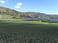
editCommercial agricultural products grown in Aquitania include onions, peas, corn, and potatoes.[1]
Born in Aquitania
edit- Arsenio Chaparro Cardoso, former professional cyclist[3]
- Freddy Montaña, professional cyclist
Gallery
edit-
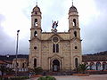 Church of Aquitania
 -
 Onion fields in Aquitania
 -
 Onion fields
 -
 Onion fields
 -
 Monument to the onion farmers


References
edit- ^ a b c (in Spanish) Official website Aquitania
- ^ "Promedios Climatológicos 1981–2010" (in Spanish). Instituto de Hidrologia Meteorologia y Estudios Ambientales. Archived from the original on 15 August 2016. Retrieved 3 June 2024.
- ^ "Arsenio Chaparro Cardoso". Cycling Archives. Retrieved 2 April 2015.