The Americus Limestone is a member of the Foraker Limestone Formation in eastern Kansas, where it is quarried as a distinctive ornamental stone. In outcrop, it is typically recognized as two relatively thin but persistent beds of hard limestone separated by shale that forms the lowest prominent bench of the many benches of the Flint Hills. The recognizable facie of the member in excavated or eroded exposures is two thin limestone beds separated a bed of shale and adjacent shales above and below having a particular gray or bluish color darker than higher limestones. A third, lower, highly variable algal limestone is often present and included as the base of the member. The unit is not particularly massive, the limestone pair totaling 3 to 4 feet (0.91 to 1.22 meters) in places, more in other locations but less to the North, and up to nearly to 9 feet (2.7 meters) at the type location of Americus, Kansas. The addition of the lower algal limestone as a base for the unit increases the thickness to over 18 feet (5.5 meters). Initially thought to be the lowest of the Permian rock of Kansas and as such classified as the lowest unit of the Council Grove Group, the unit is now dated within the uppermost Late Carboniferous.[1]
| Americus Limestone | |
|---|---|
| Stratigraphic range: [1] | |
 The Americus Limestone beds form the first bench of the Flint Hills when approaching from the east. Placed near that bench, this sign is carved from the gray-toned Americus Limestone.[2][3]
 | |
| Type | Formation member |
| Unit of | Foraker Formation of the lower Council Grove Group |
| Underlies | Hughes Creek Shale of the Foraker Formation |
| Overlies | Hamlin Shale member of the Janesville Shale |
| Lithology | |
| Primary | Limestone, shale |
| Other | stromatolite limestone, lime-sand mudstone/grainstone, flint[4] |
| Location | |
| Region | Kansas |
| Country | United States |
| Type section | |
| Named for | Americus, Kansas |
| Named by | M. Z. Kirk, University Geological Survey of Kansas[5] |
| Year defined | 1896 |
Lithologic character
editLimestone couplet: The common recognition of the Americus Limestone is a persistent, wide-ranging pair of durable limestone beds separated by shale. These two limestone beds may be referred to as upper and lower Americus Limestone beds. However, this terminology can lend to confusion with a third limestone bed that sometimes can be found below this pair, and, where found, is included within the Americus member.
"Lower Americus Limestone": 0 to 12 feet (0.0 to 3.7 metres) below the rather consistent limestone pair is a less consistent third limestone. The variability of this bed is employed to reconstruct the range of environments represented by the outcrop.[4] The base of this limestone, where present, is consistently formed of Collenia stromatolites. The stromatolite base of this limestone can overlie orange lime-sand mudstone to grainstone recording the advancement a shoreline through the area creating the open shallow sea environment where the upper limestones would form.[4][6] This bed is typically not illustrated on Group and Series scale charts.
Relatively, the paired limestones record broad environmental events across a wide shallow sea while the lowest limestone records a transgressive shoreline.

Bedding
edit- Bed #5 Limestone: Dark gray to blue-gray shalely-to-hard limestone, few inches to well over a foot thick. Abundant fusulinids and crinoid columnals.
- Bed #4 Shale/Limestone: Tan to gray shale varying from clayey to silty. This shale thins to the north, while south into Oklahoma, it becomes a limestone distinct from the limestone beds above and below.
- Bed #3 Limestone: Dark grey to blue-grey shalely-to-hard limestone, few inches to well over a foot thick. Abundant variety of macrofossils; brachiopods, pelecypods, gastropods, horn corals, etc.
- Bed #2 Shale: This shale spans the gap between the lowest limestone bed #1 and the upper pair of limestone beds and (#3 & #5). Earlier authors may have included it within the upper Hamlin Shale Member of the Janesville Shale. The depth of this bed varies from over 9 feet (2.7 meters) weastward, but thins and pinches out eastward as the lower limestone coleses with the other limestones. The depths of this bed are interpreted as indicating variations in bottom elevation of the shallow near-shore environments.[4]
- Bed #1 Limestone: This bed's foundation of tidal stromatolites are interfilled with sorted limey microfossils and covered by skeletal limestone layers of gastropods, pelecypods, and some brachiopods. Eastward towards the presumed paleoshoreline, this bed approaches and coalesces with the base of the lower of the upper paired limestone beds; while westward this bed thins and presumably disappears.[6]
- This limestone has been confused for the Houchen Creek limestone bed of the Hamlin Shale Member of the Janesville Shale. Both are limestones found below the upper paired limestones, and both have large masses of tidal Collenia stromatolite; however, the Houchen Creek's stromatolite mounds are more widely spaced and are directly blanketed by shale rather than the skeletal limestone that encases the Americus stromatolites.[6]
Commercial use
editThe limestone beds are quarried for construction material. The tougher uppermost limestone bed in particular is sold commercially as Tuxedo Gray or "Flint Hills Gray", and is popular in eastern Kansas for its abundant visible fossils, gray tone that contrasts with the buff tone of Cottonwood Limestone, and the ability of the stone to take a polish that accentuates both the fossils and darker gray color.[4][5][7]
- Examples of construction use
- Kansas State Archives, flooring, stairs, and table[8]
- Kansas State Capitol, lobby[9]
- Kansas State University Student Union, courtyard lighting plinths, walls, and fountain
- Robert J. Dole Institute of Politics, exterior lower courses
-
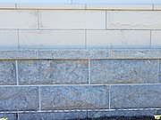 Americus Limestone: Grey contrasting with the buff Cottonwood Limestone.
 -
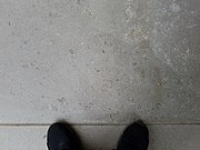 Americus Limestone: 100 year old Thompson Hall threshold, KSU.
 -
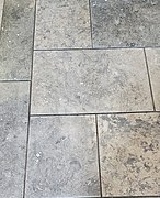 Tuxedo Grey: Kansas Historical Society archives entrance flooring
 -
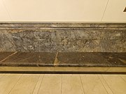 Tuxedo Grey: Kansas State Capitol - visitor entrance bench
 -
 Tuxedo Grey: Kansas State Capitol - visitor entrance wainscot
 -
 Americus Limestone: 1988 Jim Patti Buffalo sculpture, Lawrence, Kansas.


Fossils
editAs much of the Americus environment was shallow seawater with tidal currents, the formation is known for abundant, fragmented, and sorted remains of fusilinids, crinoids, brachiopods, and stromatolites.
-

-
 Fine cross section of a Linoproductus.
 -
 Tuxedo Grey: Interior lophophore structures of a Linoproductus preserved in calcite.
 -
 Tuxedo Grey: Calcite-filled Linoproductus mantle.


See also
editReferences
edit- ^ a b Robert S. Sawin, Ronald R. West, Evan K. Franseen, W. Lynn Watney (January 2006). "Carboniferous-Permian Boundary in Kansas, Midcontinent, U.S.A". Current Research in Earth Sciences. 252 (1).
Several boundaries, ranging from the Fort Riley limestone (Chase Group) down to the Americus limestone (Council Grove Group) (current terminology), were advanced ...
{{cite journal}}: CS1 maint: multiple names: authors list (link) - ^ Bobbi Mlynar (Sep 15, 2007). "New Venture : Accidental Discovery of Marble [sic] Leads Bob Davis Into a Different Business". Emporia Gazette. Retrieved 2021-12-12. The Davis quarry is on a plain underlain by shallow Americus Limestone (see KGS county maps), which Davis misidentified as marble. It is not unknown to misidentify as marble any limestone, dolomite, or anhydrite mineralised enough to take a polish. Marble is metamorphic; metaphoric rock does not outcrop in Kansas.
- ^ Brandy Nance (Aug 7, 2007). "New Venture : Flint Hills Welcome : Native marble from Lyon County used for new signs on highways". Emporia Gazette. Retrieved 2021-12-12.
- ^ a b c d e Jonathan C. Sporleder (1992). "Structural control of the distribution of subtidal to supratidal paleoenvironments of the Americus Limestone Member (lowermost bed) in eastern Kansas" (PDF). Subsurface Geology Series (13). Kansas Geological Survey.
- ^ a b Charles S. Prosser (1902). "Revised Classification of the Upper Paleozoic Formations of Kansas". The Journal of Geology. 10 (7). The University of Chicago Press: 708. Bibcode:1902JG.....10..703P. doi:10.1086/621033. JSTOR 30055865. S2CID 129704795.
- ^ a b c Melville R. Mudge and Ellis L. Yochelson (1962). "Stratigraphy and Paleontology of the Uppermost Pennsylvanian and Lowermost Permian Rocks in Kansas" (PDF). USGS Professional Paper (323): 27–34. Retrieved 2021-11-27.
- ^ "Geologic Unit: Americus". National Geologic Database. Geolex — Significant Publications. United States Geological Survey. Retrieved 2021-09-18.
- ^ State Archives & Library Limestone (PDF), Kansas Historical Society,
The interior lobby walls also feature the light-colored Cottonwood limestone. Medium dark Tuxedo Gray limestone, quarried in Jackson County by Bayer Stone of St. Marys, was used for the State Archives & Library lobby and reception area floors and the treads and risers of the main staircase.
- ^ "Kansas State Capitol - Exhibits". kshs.org. Kansas Historical Society. JSTOR 30055865. Retrieved 2023-02-26.
The gray stone found in the lobby is Tuxedo Gray limestone quarried in Kansas.
Further reading
edit- Jonathan C. Sporleder (1992). "Structural control of the distribution of subtidal to supratidal paleoenvironments of the Americus Limestone Member (lowermost bed) in eastern Kansas" (PDF). Subsurface Geology Series (13). Kansas Geological Survey.
- While the upper two limestone are consistent and reflect more open marine conditions, this study reports that the lower limestone records several different transient near-shore tidal and subtidal environments.
- "Nebraska Invertebrate Fossils - Fossils from the Hughes Creek Member, Foraker Formation". University of Nebraska, School of Natural Resources.
- The fauna of the Hughes Creek Member is very similar to the underlying Americus Limestone Member.