Alpha Mountain is a 2,302-metre (7,552-foot) summit located in the Tantalus Range, in Tantalus Provincial Park, in southwestern British Columbia, Canada. It is situated 14 km (8.7 mi) northwest of Squamish, and 4.6 km (2.9 mi) southeast of Mount Tantalus, which is the highest peak in the Tantalus Range. Its nearest higher peak is Serratus Mountain, 1.9 km (1.2 mi) to the west.[4] The Serratus Glacier lies to the west of Alpha, unnamed glaciers lie on the northern and eastern slopes, and Lake Lovely Water lies below the south slope. Precipitation runoff from the peak drains into tributaries of the Squamish River.
| Alpha Mountain | |
|---|---|
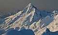
 Alpha Mountain above Lake Lovely Water (as seen from Mount Niobe) | |
| Highest point | |
| Elevation | 2,302 m (7,552 ft)[1][2] |
| Prominence | 372 m (1,220 ft)[1] |
| Parent peak | Serratus Mountain (2321 m)[1] |
| Listing | Mountains of British Columbia |
| Coordinates | 49°47′44″N 123°16′33″W / 49.79556°N 123.27583°W[3] |
| Geography | |
 Alpha Mountain Location in British Columbia  Alpha Mountain Alpha Mountain (Canada) | |
| Location | Tantalus Provincial Park British Columbia, Canada |
| District | New Westminster Land District |
| Parent range | Tantalus Range Coast Ranges |
| Topo map | NTS 92G14 Cheakamus River[3] |
| Climbing | |
| First ascent | 1914 by Basil Darling and A. Morkill[1] |
| Easiest route | Scramble via SW Ridge |
History
editThe first ascent of the mountain was made in 1914 by Basil Darling and Alan Morkill via the southwest ridge. These two named the peak shortly after they made the ascent, alluding to Alpha, which is the first letter of the Greek alphabet, because the peak is the first (southeast) summit of the Alpha-Serratus-Tantalus-Zenith Ridge, and also because of its form.[5] The mountain's toponym was officially adopted on June 6, 1957, by the Geographical Names Board of Canada.[3]
Climate
editBased on the Köppen climate classification, Alpha Mountain is located in the marine west coast climate zone of western North America.[6] Most weather fronts originate in the Pacific Ocean, and travel east toward the Coast Mountains where they are forced upward by the range (Orographic lift), causing them to drop their moisture in the form of rain or snowfall. As a result, the Coast Mountains experience high precipitation, especially during the winter months in the form of snowfall. Winter temperatures can drop below −20 °C with wind chill factors below −30 °C. The months July through September offer the most favorable weather for climbing Alpha.
Climbing Routes
editEstablished rock-climbing routes on Alpha Mountain:[1]
Gallery
edit-
 Alpha Mountain (left) and Serratus Mountain (right).
 -
 Alpha Mountain seen from the shoulder of Pelion Mountain
 -
 Alpha Mountain, northeast aspect, as seen from the Sea to Sky Highway
 -
 Alpha (left) and Mt. Tantalus, east aspect
 -
 Northeast aspect
 -
 Southeast aspect


See also
edit Media related to Alpha Mountain at Wikimedia Commons
 Mountains portal
- Geography of British Columbia
- Geology of British Columbia
References
edit- ^ a b c d e "Alpha Mountain". Bivouac.com. Retrieved 2019-11-02.
- ^ "Topographic map of Alpha Mountain". opentopomap.org. Retrieved 2024-01-13.
- ^ a b c "Alpha Mountain". Geographical Names Data Base. Natural Resources Canada. Retrieved 2019-11-03.
- ^ "Alpha Mountain, British Columbia". Peakbagger.com. Retrieved 2019-11-02.
- ^ "Alpha Mountain". BC Geographical Names. Retrieved 2019-11-02.
- ^ Peel, M. C.; Finlayson, B. L.; McMahon, T. A. (2007). "Updated world map of the Köppen−Geiger climate classification". Hydrol. Earth Syst. Sci. 11. ISSN 1027-5606.
External links
edit- Weather: Alpha Mountain
- YouTube: Climbing Alpha Mountain
- Vimeo: Climbing Alpha East Ridge