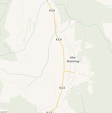
Al-Sammu'i (Arabic: السموعي) was a Palestinian Arab village in the Safad Subdistrict. It was depopulated during the 1947–1948 Civil War in Mandatory Palestine on May 12, 1948, under Operation Hiram. It was located 4 km west of Safad. Today, Kfar Shamai is built on the site of the old village, and Amirim is built on the southern part of the village land.
Al-Sammu'i
السموعي Sammu'i[1] | |
|---|---|
Village | |
A series of historical maps of the area around Al-Sammu'i (click the buttons) | |
Location within Mandatory Palestine | |
| Coordinates: 32°57′29″N 35°27′11″E / 32.95806°N 35.45306°E | |
| Palestine grid | 192/262 |
| Geopolitical entity | Mandatory Palestine |
| Subdistrict | Safad |
| Date of depopulation | May 12, 1948[1] |
| Area | |
| • Total | 15,135 dunams (15.135 km2 or 5.844 sq mi) |
| Population (1945) | |
| • Total | 310[2][3] |
| Cause(s) of depopulation | Influence of nearby town's fall |
In 1945, the village had a population of 310.[2] Al-Sammu'i had a mosque and a shrine for a local sage known as al-Shaykh Muhammad al-'Ajami.

References edit
Bibliography edit
- Barron, J.B., ed. (1923). Palestine: Report and General Abstracts of the Census of 1922. Government of Palestine.
- Conder, Claude Reignier; Kitchener, H.H. (1881). The Survey of Western Palestine: Memoirs of the Topography, Orography, Hydrography, and Archaeology. Vol. 1. London: Committee of the Palestine Exploration Fund. (pp. 200, 256)
- Guérin, Victor (1880). Description Géographique Historique et Archéologique de la Palestine (in French). Vol. 3: Galilee, pt. 2. Paris: L'Imprimerie Nationale. (p. 455)
- Hadawi, Sami (1970). Village Statistics of 1945: A Classification of Land and Area ownership in Palestine. Palestine Liberation Organization Research Center. Archived from the original on 2018-12-08. Retrieved 2009-08-18.
- Hütteroth, Wolf-Dieter; Abdulfattah, Kamal (1977). Historical Geography of Palestine, Transjordan and Southern Syria in the Late 16th Century. Erlanger Geographische Arbeiten, Sonderband 5. Erlangen, Germany: Vorstand der Fränkischen Geographischen Gesellschaft. ISBN 3-920405-41-2.(p. 177)
- Karmon, Y. (1960). "An Analysis of Jacotin's Map of Palestine" (PDF). Israel Exploration Journal. 10 (3, 4): 155–173, 244–253. Archived from the original (PDF) on 2017-12-01. Retrieved 2015-04-27. (Karmon, 1960, p. 165 Archived 2017-12-01 at the Wayback Machine)
- Khalidi, Walid (1992). All That Remains: The Palestinian Villages Occupied and Depopulated by Israel in 1948. Washington D.C.: Institute for Palestine Studies. ISBN 0-88728-224-5.
- Mills, E., ed. (1932). Census of Palestine 1931. Population of Villages, Towns and Administrative Areas. Jerusalem: Government of Palestine.
- Morris, Benny (2004). The Birth of the Palestinian Refugee Problem Revisited. Cambridge University Press. ISBN 978-0-521-00967-6.
- Palmer, E. H. (1881). The Survey of Western Palestine: Arabic and English Name Lists Collected During the Survey by Lieutenants Conder and Kitchener, R. E. Transliterated and Explained by E.H. Palmer. Committee of the Palestine Exploration Fund. (p. 93)
- Rhode, Harold (1979). Administration and Population of the Sancak of Safed in the Sixteenth Century. Columbia University. Archived from the original on 2020-03-01. Retrieved 2017-12-02.
- Robinson, E.; Smith, E. (1841). Biblical Researches in Palestine, Mount Sinai and Arabia Petraea: A Journal of Travels in the year 1838. Vol. 3. Boston: Crocker & Brewster. (p. 336, and 2nd appendix, p. 134)
- Robinson, Edward; Smith, Eli (1856). Later Biblical Researches in Palestine and adjacent regions: A Journal of Travels in the year 1852. London: John Murray. (p. 72)
- Schumacher, G. (1888). "Population list of the Liwa of Akka". Quarterly Statement - Palestine Exploration Fund. 20: 169–191. (p. 190)
External links edit
- Welcome To al-Sammu'i
- al-Sammu'i, Zochrot
- al-Sammu'i, Dr. Khalil Rizk
- Survey of Western Palestine, Map 4: IAA, Wikimedia commons


