The 2023 Wynne-Parkin tornado happened during the afternoon of March 31, 2023, as a large, deadly, and destructive rain-wrapped wedge tornado struck the cities and communities of Wynne, Parkin, Earle, Turrell, and Drummonds in Arkansas and Tennessee. The tornado caused considerable damage to Wynne and significant to severe damage to areas around the northeastern Arkansas and Western Tennessee, killing four people, injuring 16 others, and causing $150.5 million in damage. The tornado lasted 1 hour and 24 minutes and had a total path length of 73 miles (117 km) with a total path width of 1,600 yards (1,500 m).[1] This tornado was a part of the historic Tornado outbreak of March 31 – April 1, 2023, and it was the costliest tornado of the outbreak, its also the second-longest tracked tornado of the outbreak, behind the Bethel Springs, EF3 tornado. The tornado was also the second-largest tornado in the outbreak.
Top to Bottom: The rain-wrapped wedge tornado crossing in front of the road, NEXRAD Radar Imagery of the Wynne tornado. | |
| Meteorological history | |
|---|---|
| Formed | March 31, 2023, 4:30 pm. CDT (UTC−05:00) |
| Dissipated | March 31, 2023, 5:54 pm. CDT (UTC−05:00) |
| Duration | 1 hour, 24 minutes |
| EF3 tornado | |
| on the Enhanced Fujita scale | |
| Highest winds | 150 mph (240 km/h) |
| Overall effects | |
| Fatalities | 4 |
| Injuries | 26 |
| Damage | $150.55 million (2023 USD) |
| Areas affected | Wynne, Parkin, Earle, Turrell Arkansas/Drummonds, Tennessee |
Part of the Tornado outbreak of March 31-April 1, 2023 and tornadoes of 2023 | |


The tornado touched down at 4:30 p.m. CDT a few miles southwest of Wynne, quickly intensifying to EF2. It uprooted and snapped multiple trees and power lines, caused severe damage to a farmhouse, and destroyed some outbuildings. The tornado briefly weakened before restrengthening to EF2 intensity, causing significant damage to a farmstead and destroying more barns. The tornado entered Wynne at mid-range EF3 strength, destroying mobile homes and leveling poorly built structures. Wynne High School sustained major damage, and many businesses and churches were heavily damaged or destroyed. Numerous trees were snapped or uprooted in Wynne. Afterward, the tornado primarily traversed through open land, snapping or uprooting trees and power poles and overturning irrigation systems, with strength ranging from EF1 to EF2. The tornado restrengthened to EF3 near the Mississippi River, snapping and debarking multiple trees. After crossing the river, it gradually weakened before dissipating a few miles northwest of Brighton at 5:54 p.m.
Meteorological synopsis
edit
An extratropical cyclone developed over Nebraska on the morning of March 31. As a result, meteorologists expected a storm mode of discrete supercells to develop. This, along with even stronger CAPE values and a more unstable environment across Illinois and eastern Missouri, led to the SPC "bridging" the two main moderate-risk areas and giving a 15% hatched risk for significant tornadoes at their 1300 UTC outlook. The surrounding area, which extended into central portions of Kentucky and Tennessee, extreme southwestern Indiana, and northwestern Alabama, was given a 10% hatched risk for tornadoes. Additionally, a large 30% partially hatched contour for damaging wind gusts (with a smaller 45% risk in the northern part of the risk) and large hail were also added in this new outlook.[2]
With increased confidence in favorable parameters for severe weather, the SPC upped the threat for strong tornadoes even further, introducing two tornado-driven high risk areas in their 16:30 UTC outlook; it was the first high-risk issuance since March 25, 2021. In 2024, SPC forecaster and meteorologist Andrew Lyons stated, "We've been building up to this crescendo all week, knowing that pretty much all the parameters are there for something big and then one by one, each piece kind of fell in that morning."[3] The first high risk area covered southeastern Iowa, northwestern Illinois, and far northeastern Missouri, while the second included eastern Arkansas, southwestern Tennessee, and northern Mississippi. These two distinct areas were given a 30% hatched risk for tornadoes, given the extremely favorable environment for developing and sustaining discrete supercells with strong to violent tornado potential. The northern high-risk area was expected to see an arcing band of quasi-discrete supercells that would initially produce large hail before becoming tornadic, possibly producing several long-track strong to potentially violent tornadoes. Supercells would be more scattered but longer tracked within the southern high-risk area, with multiple rounds of tornadic storms capable of producing long-lived strong to violent tornadoes expected. The large area surrounding and connecting the two high-risk areas maintained a moderate risk, with an accompanying 15% hatched risk for tornadoes, as supercells that could develop in this environment could similarly sustain and rotate. However, storm coverage was expected to be somewhat lower, and the environment would not be as favorable. Throughout the main risk area, an elevated risk for damaging winds and large hail were also issued, with the supercells initially capable of producing huge hail and long-tracked tornadoes expected to transition into QLCS structures capable of producing very strong straight-line winds and additional tornadoes that evening.[4] Soon after the upgrade into a high risk, the SPC introduced their first two particularly dangerous situation tornado watches, indicating a 90-95% chance for multiple tornadoes, and a 90% chance for multiple strong to violent tornadoes.[5][6]
Tornado track
edit
Arkansas
editThe tornado formed at 4:30 p.m. CDT, six miles southeast of Fair Oaks, immediately intensifying to high-end EF1, and destroying a barn on Cecil Peevey Rd. The tornado traveled east, crossing Elmer Owens Rd, where it strengthened to mid-range EF2 intensity. A farmstead sustained significant damage as the roof of the home was ripped away, many nearby trees were uprooted, and a trailer and vehicle were tossed. Trees were also snapped along Arkansas Highway 284. The tornado then crossed Arkansas Highway 193, slightly weakening to low-end EF2. It snapped multiple power poles and uprooted trees near the Ellis Chapel United Methodist Church; a double-wide mobile home was rolled over, an outbuilding was destroyed, and a metal building was leveled. Additionally, a home on County Road 640 sustained minor roof damage.[7]

Wynne, Arkansas
editThe tornado re-intensified to EF2 strength, ripping the roof off a brick home and snapping power poles. An 80-yard-long shed with metal beams for roofing joists failed and was thrown; the roofing was compressed and leveled two cinder block buildings before landing 100 yards away. A swath of snapped trees was noted on Bowden St S, and many softwood trees were uprooted. A home suffered minimal damage further upstream.[8] Maintaining EF2 intensity, the tornado entered Wynne, first crossing 11th St W. A mobile home on Merriman Ave was destroyed, with all debris blown away, and trees in the immediate vicinity were knocked over. The tornado then intensified to low-end EF3 intensity. An elementary school on Garfield Ave sustained severe damage as the load-bearing walls collapsed; two rail cars nearby were moved, and a home on L St was almost leveled, with only a few interior walls left standing. The tornado crossed Cogbill Ave, reaching a peak intensity of 150 mph (240 km/h). The Star 2 convenience store along the road was destroyed.[9][7] The tornado crossed Williams Ave Rd, slightly weaker at low-end EF3. A low-rise building suffered considerable damage to its exterior walls, with some damage to the interior walls, and a home's roof was heavily damaged. The tornado heavily damaged First Baptist Church, which was later rebuilt a year afterward.[10]

The tornado re-attained to mid-range EF3 intensity north of downtown Wynne, a home on Williams Ave Rd was leveled at 150 mph (240 km/h), another home on Terry St N was mostly destroyed, leaving a few interior walls on the foundations, noted significant roof damage on homes along Wilson St and some trees fell on homes.[7] More trees were snapped and uprooted as the tornado weakened to low-end EF3; a large tree fell onto a home on Poplar Ave, leveling all of the structure and killing two people inside the home.[11][12] Two homes nearby had their roofs ripped away and suffered partial wall collapses. The tornado crossed Forrest Ave, shifting an entire house off its foundation. A home on N Garland Rd was completely leveled, leaving only one wall standing. Wynne First United Methodist Church sustained severe damage from the tornado, with windows shattered and the steeple ripped away.[13][7] The tornado crossed E Jackson Ave and directly impacted Wynne High School, causing extreme damage to the building. Windows were blown out, and the roof suffered extensive damage. The building was described as a "total loss," with most of the school being torn down and scrapped.[14][15][16] A metal building on the campus was crumpled, and the football stadium was badly damaged, parts of the astroturf on the football field was ripped up. [17][18] Free-standing lights toppled onto the road, and two homes on Forrest Ave sustained significant damage: one home had its exterior walls collapse, and the other lost its roof.[7]
The tornado maintained EF3 status as it crossed E L Anguille Ave, collapsing the exterior walls of two homes on the road. The tornado then restrengthened to 150 mph (240 km/h), mostly leveling a brick home on Airpark Rd. Another nearby home lost most of its roof, and a home on Peterson Rd sustained major damage, with most of the structure being leveled. Another home on the road had its roof ripped away and parts of its walls collapsed; a home further south was destroyed and reduced to its interior walls, while a home farther northeast along Aarron Dr received significant roof damage..[7] Weakening to EF2 intensity, the tornado removed the roof of a home on Almetta Dr. As the tornado approached Highway 64, it rapidly intensified to low-end EF3 strength, leveling a poorly built home. The tornado continued to rip away roofs and cause moderate to severe exterior wall damage before leaving Wynne.[8][19][7]
Rural Areas
editAfter leaving Wynne, the tornado weakened to EF1 intensity as it crossed U.S. Route 64, snapping numerous trees along the highway. Around the same time, at 4:56 p.m. CDT, the National Weather Service in Memphis issued a tornado emergency for Cross County and Crittenden County in Arkansas.[20] The tornado continued east, leveling an outbuilding on the highway. The tornado passed north of Parkin, crossing the St. Francis River, where multiple trees around the riverbank were snapped or uprooted at EF1 intensity. Northeast of Parkin, the tornado strengthened again, snapping two power poles on State Highway 184 and overturning 20-30 center pivot irrigation systems at 125 mph (201 km/h). [21] On the same highway, many softwood and hardwood trees were snapped and uprooted, a farmstead sustained significant roof damage, and more power poles were snapped. North of Earle, the tornado weakened back to EF1 intensity, snapping multiple trees and wooden power poles, and blowing over pivot irrigation systems.[7] TThe tornado briefly reached EF2 intensity southwest of Turrell, snapping some electrical transmission lines on Bob White Rd. Around the same time, at 5:23 p.m. CDT, the National Weather Service issued another tornado emergency for Crittenden, Mississippi, Shelby, and Tipton counties in Arkansas and Tennessee.[22]

The tornado followed the oxbows of the Mississippi River, reintensifying to EF2 intensity, where significant tree damage was noted as multiple trees were snapped or uprooted.[23] The tornado crossed into Tennessee again, where it further strengthened to low-end EF3 status with estimated wind speeds of 145 mph (233 km/h). Multiple trees around Corna Lake were blown down and debarked. Maintaining EF3 intensity, the tornado crossed back into Arkansas, where more trees along the Mississippi River were snapped and debarked before it crossed the river into Tennessee again.[24] Upon re-entering Tennessee, the tornado immediately snapped and debarked many trees, with additional trees being snapped and suffering minor debarking near Wilder Farm. The tornado weakened to EF1 intensity, causing minimal roof damage to a mobile home and uprooting more trees north of Drummonds. The tornado dissipated south of Burlison at 5:54 p.m. CDT, 1 hour and 24 minutes after it touched down. The parent supercell then produced the Covington EF3 tornado 3.5 miles (5.6 km) to the south of the Wynne tornado.[25]
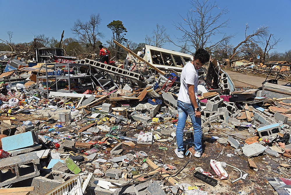
Aftermath
edit.jpg)
Sarah Huckabee Sanders, Governor of Arkansas, ordered the deployment of 100 Arkansas National Guard troops and released $250,000 in emergency funds for relief efforts. Sanders also declared a state of emergency.[26] Sanders went to Wynne on April 3 to tour the damage left by the tornado.[27] On April 12, Federal Emergency Management Agency and State of Arkansas opened a joint Disaster Recovery Center in Wynne, Arkansas to help survivors who were affected by the tornado. Local non-profit organizations and other agencies opened up one-stop shops for survivors.[28] The Salvation Army provided over 25,222 meals, 9,903 drinks, and 16.383 snacks for victims affected by the tornado, as well as providing emotional and spiritual support for 991 people.[29] The Memphis Area Command sent a team to Wynne to cook 150 meals at the Wynne Central Fire Department. [30]
See also
editReferences
edit- ^ Tennessee, National Weather Service Memphis (2023-04-24). "March 31, 2023 Mid-South Tornado Outbreak". ArcGIS StoryMaps. Retrieved 2024-08-13.
- ^ "Mar 31, 2023 1300 UTC Day 1 Convective Outlook". March 31, 2023. Archived from the original on April 1, 2023. Retrieved March 31, 2023.
- ^ Olsen, Max; Lyons, Andrew; Greenwood, Trey; Hernandez, Jacob; Charles, Tanner; Wright, Taylor; Pitts, Devin; Hall, Zachary (30 March 2024). "3/31/2023 - The Tornado Outbreak of the Decade" (Video & Interviews). YouTube. @MaxOlsonChasing. Archived from the original on 31 March 2024. Retrieved 31 March 2024.
- ^ "Mar 31, 2023 1630 UTC Day 1 Convective Outlook". March 31, 2023. Archived from the original on April 1, 2023. Retrieved March 31, 2023.
- ^ "Tornado Watch #93". National Weather Service. Archived from the original on April 1, 2023. Retrieved March 31, 2023.
- ^ "Tornado Watch #94". National Weather Service. Archived from the original on April 1, 2023. Retrieved March 31, 2023.
- ^ a b c d e f g h "ArcGIS Web Application". apps.dat.noaa.gov. Retrieved 2024-08-13.
- ^ a b "EF3 Wynne: Storm Events Database - Event Details | National Centers for Environmental Information". www.ncdc.noaa.gov. Retrieved 2024-08-13.
- ^ McFadin, Daniel (April 1, 2023). "Storm-hit Wynne sizes up its losses".
- ^ Sexton, Maddie (17 June 2024). "Small town sanctuary's first service since the storm". kait8. Retrieved 15 August 2024.
- ^ "Family, friends recall victims of tornado's terror in Wynne | Arkansas Democrat Gazette". www.arkansasonline.com. 2024-03-29. Retrieved 2024-08-14.
- ^ "Wynne family mourns the loss of couple that died in Friday's tornado". KARK. 2023-04-06. Retrieved 2024-08-14.
- ^ "Local church helps the community of Wynne cleans up severe storm damage aftermath". FOX13 Memphis. 2023-04-02. Retrieved 2024-08-14.
- ^ "Wynne High School finding ways to recover nearly a month after tornado". KARK. 2023-04-28. Retrieved 2024-08-14.
- ^ "PHOTOS: Wynne, Arkansas, devastated by storms, likely tornado". The Commercial Appeal. Retrieved 2024-08-14.
- ^ "Drone video shows devastation in Wynne, Arkansas after tornado slams town". localmemphis.com. 2023-04-01. Retrieved 2024-08-14.
- ^ Fisher, Jeff (2023-04-04). "Deadly Arkansas tornado destroys Wynne High School and football stadium". High School Football America. Retrieved 2024-08-14.
- ^ A tornado destroyed an Arkansas football field. See what's left | CNN. 2023-04-01. Retrieved 2024-08-14 – via www.cnn.com.
- ^ "Family, friends recall victims of tornado's terror in Wynne | Arkansas Democrat-Gazette". www.arkansasonline.com. 2024-03-29. Retrieved 2024-08-14.
- ^ akrherz@iastate.edu, daryl herzmann. "IEM :: Valid Time Event Code (VTEC) App". mesonet.agron.iastate.edu. Retrieved 2024-08-14.
- ^ "Storm Events Database - Event Details | National Centers for Environmental Information". www.ncdc.noaa.gov. Retrieved 2024-08-14.
- ^ akrherz@iastate.edu, daryl herzmann. "IEM :: Valid Time Event Code (VTEC) App". mesonet.agron.iastate.edu. Retrieved 2024-08-14.
- ^ "Storm Events Database - Event Details | National Centers for Environmental Information". www.ncdc.noaa.gov. Retrieved 2024-08-14.
- ^ "Storm Events Database - Event Details | National Centers for Environmental Information". www.ncdc.noaa.gov. Retrieved 2024-08-14.
- ^ "Storm Events Database - Event Details | National Centers for Environmental Information". www.ncdc.noaa.gov. Retrieved 2024-08-14.
- ^ https://www.kark.com/severe-weather-coverage/arkansas-little-rock-officials-detail-tornado-response-after-friday-storms/.
{{cite web}}: Missing or empty|title=(help) - ^ "Arkansas governor surveys tornado damage in Wynne". KUAR. 2023-04-03. Retrieved 2024-08-14.
- ^ "Wynne Tornado Relief | United Way of Northeast Arkansas". www.uwnea.org. Retrieved 2024-08-14.
- ^ "Community Strength and Unity in the Wake of Tornadoes in Wynne, Arkansas with The Salvation Army Providing Uplifting Support". disaster.salvationarmyusa.org. Retrieved 2024-08-14.
- ^ Gallant, Jacob (2023-04-01). "Salvation Army to help relief efforts in Arkansas, Tennessee following storms". actionnews5. Retrieved 2024-08-14.