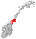
Øvre Stjørdal or Øvre Stjørdalen is a former municipality in the old Nordre Trondhjem county in Norway. The 1,913-square-kilometre (739 sq mi) municipality existed from 1850 until its dissolution in 1874. The municipality encompassed the upper part of the Stjørdalen valley which includes what is now the municipality of Meråker and the Hegra area of the municipality of Stjørdal, both in Trøndelag county. The administrative centre of the municipality was the village of Hegra where the Hegra Church is located.[3][4]
Øvre Stjørdalen Municipality
Øvre Stjørdalen herad | |
|---|---|
 Nord-Trøndelag within Norway | |
| Coordinates: 63°27′56″N 11°29′44″E / 63.4656°N 11.4955°E | |
| Country | Norway |
| County | Nord-Trøndelag |
| District | Stjørdalen |
| Established | 1850 |
| • Preceded by | Stjørdalen Municipality |
| Disestablished | 1 Jan 1874 |
| • Succeeded by | Hegra and Meråker |
| Administrative centre | Hegra |
| Area (upon dissolution) | |
| • Total | 1,913 km2 (739 sq mi) |
| Population (1874) | |
| • Total | 1,861 |
| • Density | 0.97/km2 (2.5/sq mi) |
| Demonym | Stjørdaling[1] |
| Time zone | UTC+01:00 (CET) |
| • Summer (DST) | UTC+02:00 (CEST) |
| ISO 3166 code | NO-1711[2] |
History
editThe municipality was established in 1850 when the old municipality of Stjørdalen was divided into Øvre Stjørdal (population: 5,100) and Nedre Stjørdal (population: 6,543). On 1 January 1874, the municipality of Øvre Stjørdal ceased to exist when it was split to form two new municipalities: Hegra (population: 3,409) in the east and Meraker (population: 1,861) in the west.[5]
Name
editThe municipality (originally the parish) is named after the Stjørdalen valley (Old Norse: Stjórardalr). The first element is the word Øvre which means "upper", referring to the fact that it is the upper part of the valley. The second element is the genitive case of the local river name Stjór (now called the Stjørdalselva river). The meaning of the river name is unknown. The last element is dalr which means "valley" or "dale".[6]
Government
editDuring its existence, this municipality was governed by a municipal council of elected representatives, which in turn elected a mayor.[7]
Mayors
editThe mayors of Øvre Stjørdal:[8]
- 1850–1851: Haftor Gundersen Skjelstad
- 1851–1853: Halvor Johnsen Øverkil
- 1854–1857: Sivert Andreas Fergstad
- 1858–1861: Johannes Røyem
- 1862–1865: Jens Henrik Winsnes
- 1866–1869: Johannes Røyem
- 1869–1873: Halvor Johnsen Øverkil
See also
editReferences
edit- ^ "Navn på steder og personer: Innbyggjarnamn" (in Norwegian). Språkrådet.
- ^ Bolstad, Erik; Thorsnæs, Geir, eds. (26 January 2023). "Kommunenummer". Store norske leksikon (in Norwegian). Kunnskapsforlaget.
- ^ Helland, Amund (1909). "Hegre herred". Norges land og folk: Nordre Trondhjems amt (in Norwegian). Norway: H. Aschehoug & Company. p. 50. Retrieved 23 March 2018.
- ^ Helland, Amund (1909). "Meraker herred". Norges land og folk: Nordre Trondhjems amt (in Norwegian). Norway: H. Aschehoug & Company. p. 30. Retrieved 23 March 2018.
- ^ Jukvam, Dag (1999). Historisk oversikt over endringer i kommune- og fylkesinndelingen (PDF) (in Norwegian). Statistisk sentralbyrå. ISBN 9788253746845.
- ^ Rygh, Oluf (1903). Norske gaardnavne: Nordre Trondhjems amt (in Norwegian) (15 ed.). Kristiania, Norge: W. C. Fabritius & sønners bogtrikkeri. p. 30.
- ^ Hansen, Tore; Vabo, Signy Irene, eds. (20 September 2022). "kommunestyre". Store norske leksikon (in Norwegian). Kunnskapsforlaget. Retrieved 1 January 2023.
- ^ Røe, Tormod (1987). Stjørdal kommune 1837–1987. Kommunalt selvstyre 150 år (in Norwegian). Stjørdal kommune. p. 352. ISBN 8299161401.

