DesktopMobile
Test of: Transclude files as random slideshow/sandbox
-
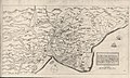
 Hand-drawn map of Kent, Sussex, Surrey and Middlesex from 1575. (from Kent)
 -

-
 View of the White Cliffs of Dover from France (from Kent)
 -
-
-
-

-
 Canterbury Cathedral (from Kent)
 -
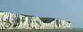 The White Cliffs of Dover (from Kent)
 -
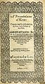 Title page of William Lambarde's Perambulation of Kent (completed in 1570 and published in 1576), a historical description of Kent and the first published county history (from Kent)
 -
 An early mention of Kent in the Anglo-Saxon Chronicle between 11th and 12th centuries (from Kent)
 -

-
 Geological cross-section of Kent, showing how it relates to major towns (from Kent)
 -
 A map of Romney Marsh "The history of imbanking and drayning" by William Dugdale (1662). (from Kent)
 -
 The coat of arms of Kent County Council (from Kent)


Apr2006.jpg)


.jpg)

Test of: Transclude linked excerpts as random slideshow/sandbox
-
 Rochester Cathedral, formally the Cathedral Church of Christ and the Blessed Virgin Mary, is in Rochester, Kent, England. The cathedral is the mother church of the Anglican Diocese of Rochester and seat (cathedra) of the Bishop of Rochester, the second oldest bishopric in England after that of the Archbishop of Canterbury. The cathedral, built in the Norman style is a Grade I listed building. (Full article...)
 -
Ivor the Engine is a British cutout animation television series created by Oliver Postgate and Peter Firmin's Smallfilms company. It follows the adventures of a small green steam locomotive who lives in the "top left-hand corner of Wales" and works for The Merioneth and Llantisilly Railway Traction Company Limited. His friends include Jones the Steam, Evans the Song and Dai Station, among many other characters. (Full article...)
-
In England, a City Technology College (CTC) is an urban all-ability specialist school for students aged 11 to 18 specialising in science, technology and mathematics. They charge no fees and are independent of local authority control, being overseen directly by the Department for Education. One fifth of the capital costs are met by private business sponsors, who also own or lease the buildings. The rest of the capital costs, and all running costs, are met by the Department. (Full article...)
-
The following is a list of recreational walks in Kent, England. (Full article...)
-
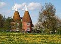
An oast, oast house or hop kiln is a building designed for kilning (drying) hops as part of the brewing process. They can be found in most hop-growing (and former hop-growing) areas and are often good examples of vernacular architecture. Many redundant oasts have been converted into houses. The names oast and oast house are used interchangeably in Kent and Sussex. In Surrey, Hampshire, Herefordshire and Worcestershire they are called hop kilns. (Full article...)
-
Folkestone (/ˈfəʊkstən/ FOHK-stən) is a port town on the English Channel, in Kent, south-east England. The town lies on the southern edge of the North Downs at a valley between two cliffs. It was an important harbour, shipping port and fashionable coastal resort for most part of the 19th and mid 20th centuries. (Full article...)
-
The Kent Cricket League is the top level of competition for recreational club cricket in Kent, England. (Full article...)
-
Gravesham (/ˈɡreɪvʃəm/ GRAYV-shəm) is a local government district with borough status in north-west Kent, England. The council is based in its largest town of Gravesend. The borough is indirectly named after Gravesend, using the form of the town's name as it appeared in the Domesday Book of 1086. The district also contains Northfleet and a number of villages and surrounding rural areas. (Full article...)
-
The Bronze Age is a historical period lasting from approximately 3300 to 1200 BC. It is characterized by the use of bronze, the use of writing in some areas, and other features of early urban civilization. The Bronze Age is the middle principal period of the three-age system, between the Stone and Iron Ages. This system was proposed in 1836 by Christian Jürgensen Thomsen for classifying and studying ancient societies and history. Worldwide, the Bronze Age generally followed the Neolithic period, with the Chalcolithic serving as a transition. (Full article...)
-
Academy FM (Thanet) is a Charity community 24-hour local radio station based in Ramsgate, Kent, England, which broadcasts to the Isle of Thanet. It launched on 5 April 2010, Easter Monday. (Full article...)
-
Margate is a seaside town in the Thanet District of Kent, England. It is located on the north coast of Kent and covers an area of 2 miles (3 kilometres) long, 16 miles (26 kilometres) north-east of Canterbury and includes Cliftonville, Garlinge, Palm Bay and Westbrook. In 2011 it had a population of 61,223. (Full article...)
-
The White Cliffs of Dover are the region of English coastline facing the Strait of Dover and France. The cliff face, which reaches a height of 350 feet (110 m), owes its striking appearance to its composition of chalk accented by streaks of black flint, deposited during the Late Cretaceous. The cliffs, on both sides of the town of Dover in Kent, stretch for eight miles (13 km). The White Cliffs of Dover form part of the North Downs. A section of coastline encompassing the cliffs was purchased by the National Trust in 2016. (Full article...)
-
The Neolithic or New Stone Age (from Greek νέος néos 'new' and λίθος líthos 'stone') is an archaeological period, the final division of the Stone Age in Europe, Asia and Africa. It saw the Neolithic Revolution, a wide-ranging set of developments that appear to have arisen independently in several parts of the world. This "Neolithic package" included the introduction of farming, domestication of animals, and change from a hunter-gatherer lifestyle to one of settlement. The term 'Neolithic' was coined by Sir John Lubbock in 1865 as a refinement of the three-age system. (Full article...)
-
In Great Britain and Ireland, a county town is the most important town or city in a county.[dubious ] It is usually the location of administrative or judicial functions within a county, and the place where public representatives are elected to parliament. Following the establishment of county councils in England 1889, the headquarters of the new councils were usually established in the county town of each county; however, the concept of a county town pre-dates these councils. (Full article...)
-
Lee, also known as Lee Green, is an area of South East London, England, straddling the border of the London Borough of Lewisham and the Royal Borough of Greenwich. It is located northwest of Eltham and southeast of Lewisham. It was in Kent before becoming part of the County of London in 1889, and then Greater London in 1965. (Full article...)
-
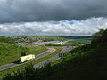
High Speed 1 (HS1), legally the Channel Tunnel Rail Link (CTRL), is a 109.9-kilometre (68.3-mile) high-speed railway linking London with the Channel Tunnel. (Full article...)
-
Sittingbourne is an industrial town in the Swale district, in Kent, southeast England, 17 miles (27 km) from Canterbury and 45 miles (72 km) from London, beside the Roman Watling Street, an ancient British trackway used by the Romans and the Anglo-Saxons. (Full article...)
-
Manston Airport (IATA: MSE, ICAO: EGMH) was a British airport. Originally operated as RAF Manston, from 1918, it has also operated as a commercial airport and was known as Kent International Airport and, briefly, London Manston Airport. It has been closed since 2014. Located in the parish of Minster-in-Thanet and partly adjacent to the village of Manston in the Thanet district of Kent, England, 11 NM (20 km; 13 mi) north-east of Canterbury. (Full article...)
-
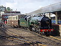
South Eastern Trains (stylised as Southeastern) was a publicly owned train operating company that operated the South Eastern Passenger Rail Franchise between November 2003, when it took over from Connex South Eastern, and 1 April 2006, when Southeastern began operating the new Integrated Kent franchise. (Full article...)
-
Chatham (/ˈtʃætəm/ CHAT-əm) is a town located within the Medway unitary authority in the ceremonial county of Kent, England. The town forms a conurbation with neighbouring towns Gillingham, Rochester, Strood and Rainham. In 2020 it had a population of 80,596. (Full article...)
-
The Darent is a Kentish tributary of the River Thames and takes the waters of the River Cray as a tributary in the tidal portion of the Darent near Crayford. 'Darenth' is frequently found as the spelling of the river's name in older books and maps, Bartholomew's Canals and River of England being one example. Bartholomew's Gazetteer (1954) demonstrates that Darent means "clear water", a result of it springing from and running through chalk. The purity of the water was a major factor in the development of paper and pharmaceuticals in the area. (Full article...)
-
The Isle of Thanet (/ˈθænɪt/) is a peninsula forming the easternmost part of Kent, England. While in the past it was separated from the mainland by the 600-metre-wide (2,000 ft) Wantsum Channel, it is no longer an island. (Full article...)
-
The Atlantic Ocean is the second-largest of the world's five oceanic divisions, with an area of about 85,133,000 km2 (32,870,000 sq mi). It covers approximately 17% of Earth's surface and about 24% of its water surface area. During the Age of Discovery, it was known for separating the New World of the Americas (North America and South America) from the Old World of Afro-Eurasia (Africa, Asia, and Europe). (Full article...)
-
Mary I (18 February 1516 – 17 November 1558), also known as Mary Tudor, and as "Bloody Mary" by her Protestant opponents, was Queen of England and Ireland from July 1553 and Queen of Spain and the Habsburg dominions as the wife of King Philip II from January 1556 until her death in 1558. She is best known for her vigorous attempt to reverse the English Reformation, which had begun during the reign of her father, King Henry VIII. Her attempt to restore to the Church the property confiscated in the previous two reigns was largely thwarted by Parliament, but during her five-year reign, Mary had over 280 religious dissenters burned at the stake in the Marian persecutions. (Full article...)
-
The River Medway is a river in South East England. It rises in the High Weald, West Sussex and flows through Tonbridge, Maidstone and the Medway conurbation in Kent, before emptying into the Thames Estuary near Sheerness, a total distance of 70 miles (113 km). About 13 miles (21 km) of the river lies in East Sussex, with the remainder being in Kent. (Full article...)
