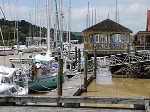
Whangārei Central is the central suburb and business district of Whangārei, in the Northland Region of New Zealand's North Island. It includes the Whangārei Town Basin.[3] It has traditionally been the main commercial centre of Northland.[clarification needed] As of 2017, approximately 39% of the 1404 businesses were commercial and professional services; 19% were retail and food businesses.[4]
Whangārei Central | |
|---|---|
 Marina at Whangārei Town Basin | |
 | |
| Coordinates: 35°43′32″S 174°19′24″E / 35.725543°S 174.323327°E | |
| Country | New Zealand |
| City | Whangārei |
| Local authority | Whangarei District Council |
| Electoral ward | Whangārei Urban Ward |
| Area | |
| • Land | 281 ha (694 acres) |
| Population (June 2023)[2] | |
| • Total | 980 |
| Avenues | Regent | |
|
|
(Hātea River) | |
| Woodhill | Morningside | Riverside, Whangārei |
In March 2019, Whangarei District Council decided to build a new precinct on the north-western side of the CBD.[5]
Demographics
editWhangarei Central covers 2.81 km2 (1.08 sq mi)[1] and had an estimated population of 980 as of June 2023,[2] with a population density of 349 people per km2.
| Year | Pop. | ±% p.a. |
|---|---|---|
| 2006 | 894 | — |
| 2013 | 759 | −2.31% |
| 2018 | 954 | +4.68% |
| Source: [6] | ||
Whangarei Central had a population of 954 at the 2018 New Zealand census, an increase of 195 people (25.7%) since the 2013 census, and an increase of 60 people (6.7%) since the 2006 census. There were 375 households, comprising 483 males and 471 females, giving a sex ratio of 1.03 males per female. The median age was 46.1 years (compared with 37.4 years nationally), with 129 people (13.5%) aged under 15 years, 168 (17.6%) aged 15 to 29, 477 (50.0%) aged 30 to 64, and 177 (18.6%) aged 65 or older.
Ethnicities were 61.3% European/Pākehā, 28.0% Māori, 6.0% Pacific peoples, 14.5% Asian, and 2.2% other ethnicities. People may identify with more than one ethnicity.
The percentage of people born overseas was 29.2, compared with 27.1% nationally.
Although some people chose not to answer the census's question about religious affiliation, 49.1% had no religion, 33.6% were Christian, 2.5% had Māori religious beliefs, 1.6% were Hindu, 2.8% were Muslim, 2.5% were Buddhist and 4.1% had other religions.
Of those at least 15 years old, 147 (17.8%) people had a bachelor's or higher degree, and 153 (18.5%) people had no formal qualifications. The median income was $23,200, compared with $31,800 nationally. 87 people (10.5%) earned over $70,000 compared to 17.2% nationally. The employment status of those at least 15 was that 339 (41.1%) people were employed full-time, 123 (14.9%) were part-time, and 45 (5.5%) were unemployed.[6]
Features
editWhangārei Central has several art galleries:
References
edit- ^ a b "ArcGIS Web Application". statsnz.maps.arcgis.com. Retrieved 21 April 2022.
- ^ a b "Population estimate tables - NZ.Stat". Statistics New Zealand. Retrieved 25 October 2023.
- ^ Hariss, Gavin. "Whangarei, Northland". topomap.co.nz. NZ Topo Map.
- ^ "Whangarei District Centre Plan" (PDF). wdc.govt.nz. Whangarei District Council.
- ^ "Site chosen for Whangārei's $37 million civic centre". New Zealand Media and Entertainment. Northern Advocate. 9 March 2019.
- ^ a b "Statistical area 1 dataset for 2018 Census". Statistics New Zealand. March 2020. Whangarei Central (107100). 2018 Census place summary: Whangarei Central
- ^ "Hundertwasser Arts Centre". Hundertwasser Arts Centre.
- ^ "Reyburn House Art Gallery". Reyburn House Art Gallery.
- ^ "Reyburn House Art Gallery on NZ Museums". nzmuseums.co.nz. Te Papa.
- ^ "Whangārei Art Museum Te Manawa Toi". Whangārei Art Museum Te Manawa Toi.
- ^ "Whangārei Art Museum Te Manawa Toi on NZ Museums". nzmuseums.co.nz. Te Papa.