This article needs additional citations for verification. (February 2014) |
In physical geography, a steppe (/stɛp/) is an ecoregion characterized by grassland plains without closed forests except near rivers and lakes.[1] Steppe biomes may include:
- the montane grasslands and shrublands biome
- the tropical and subtropical grasslands, savannas, and shrublands biome
- the temperate grasslands, savannas, and shrublands biome


A steppe is usually covered with grass and shrubs, depending on the season and latitude. The term steppe climate denotes a semi-arid climate, which is encountered in regions too dry to support a forest, but not dry enough to be a desert.
Steppes are usually characterized by a semi-arid or continental[citation needed] climate. Extremes can be recorded in the summer of up to 45 °C (115 °F) and in winter of down to −55 °C (−65 °F). Besides this major seasonal difference, fluctuations between day and night are also very great. In both the highlands of Mongolia and northern Nevada, 30 °C (85 °F) can be reached during the day with sub-freezing readings at night.
Steppes average 250–500 mm (10–20 in) of annual precipitation and feature hot summers and cold winters when located in mid-latitudes. In addition to the precipitation level, its combination with potential evapotranspiration defines a steppe climate.
Classification edit
Steppe can be classified by climate:[2]
- Temperate steppe: the true steppe, found in continental climates[failed verification] can be further subdivided, as in the Rocky Mountains Steppes[2]
- Subtropical steppe: a similar association of plants occurring in the driest areas with a Mediterranean climate[failed verification]; it usually has a short wet period
It can also be classified by vegetation type, e.g. shrub-steppe and alpine-steppe.
Cold steppe edit
The world's largest steppe region, often referred to as "the Great Steppe", is found in Eastern Europe and Central Asia, and neighbouring countries stretching from Ukraine in the west through Russia, Kazakhstan, Turkmenistan and Uzbekistan to the Altai, Koppet Dag and Tian Shan ranges in China. The Eurasian Steppe is speculated by David W. Anthony to have had a role in the spread of the horse, the wheel and Indo-European languages.[3] In the Eurasian steppe, soils often consist of chernozem.
The inner parts of Anatolia in Turkey, Central Anatolia and East Anatolia in particular and also some parts of Southeast Anatolia, as well as much of Armenia and Iran are largely dominated by cold steppe.
The Pannonian Plain is another steppe region in Central Europe, centered in Hungary but also including portions of Slovakia, Poland, Ukraine, Romania, Serbia, Croatia, Slovenia, and Austria. Another large steppe area (prairie) is located in the central United States, western Canada and the northern part of Mexico. The shortgrass prairie steppe is the westernmost part of the Great Plains region. The Columbia Plateau in southern British Columbia, Oregon, Idaho, and Washington state, is an example of a steppe region in North America outside of the Great Plains.
In South America, cold steppe can be found in Patagonia and much of the high elevation regions east of the southern Andes.
Relatively small steppe areas can be found in the interior of the South Island of New Zealand.
In Australia, a moderately sized temperate steppe region exists in the northern and northwest regions of Victoria, extending to the southern and mid regions of New South Wales. This area borders the semi-arid and arid Australian Outback which is found farther inland on the continent.
Subtropical steppe edit
In Europe, some Mediterranean areas have a steppe-like vegetation, such as central Sicily in Italy, southern Portugal, parts of Greece in the southern Athens area,[4] and central-eastern Spain, especially the southeastern coast (around Murcia), and places cut off from adequate moisture due to rain shadow effects such as Zaragoza.
In Asia, a subtropical steppe can be found in semi-arid lands that fringe the Thar Desert of the Indian subcontinent as well as much of the Deccan Plateau in the rain shadow of the Western Ghats, and the Badia of the Levant.
In Australia, subtropical steppe can be found in a belt surrounding the most severe deserts of the continent and around the Musgrave Ranges.
In North America this environment is typical of transition areas between zones with a Mediterranean climate and true deserts, such as Reno, Nevada, the inner part of California, and much of western Texas and adjacent areas in Mexico.
-
 Steppe in Mongolia
 -
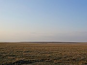 Steppe in Kazakhstan
 -
 Steppe in Turkey
 -
 Steppe in Russia
 -
 Steppe in Hungary
 -
 Steppe in Kherson, Ukraine
 -
 Southern Siberian steppe: windbreaker trees in the wintertime
 -
 Cold Patagonian steppe near Fitz Roy, Argentina
 -
 A guanaco in the Patagonian steppe near Torres del Paine, Chile
 -
 Prairie in Alberta, Canada
 -

-
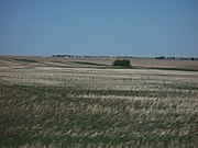
 Steppe in West Texas


See also edit
References edit
- ^
Compare:
Chibilyov, Alexander (2002). "Steppe and Forest-steppe". In Shahgedanova, Maria (ed.). The Physical Geography of Northern Eurasia. Oxford regional environments. Vol. 3 (reprint ed.). Oxford: Oxford University Press (published 2003). p. 248. ISBN 9780198233848. Retrieved 30 January 2020.
There are many definitions of steppes. For example, Allan (1946) provides fifty-four definitions of this term. Stamp and Clark (1979) define steppes as 'mid-latitude areas dominated by herbaceous vegetation and termed locally steppes, prairies, pampas, high veldts, downland, etc.'
- ^ a b "Ecoregions of the United States-Ecological Subregions of the United States". fs.usda.gov. U.S. Forest Service, U.S. Department of Agriculture. Retrieved 25 October 2016.
- ^ Anthony, David W. (15 August 2010) [2007]. The Horse, the Wheel, and Language: How Bronze-Age Riders from the Eurasian Steppes Shaped the Modern World (reprint ed.). Princeton: Princeton University Press (published 2010). p. 240. ISBN 9780691148182. Retrieved 12 June 2022.
[...] the critical era when innovative Proto-Indo-European dialects began to spread across the steppes.
- ^ "Hellinikon". HNMS.gr. Greece: Hellenic National Meteorological Service. Archived from the original on 2007-03-12. Retrieved 2013-09-08.
Sources edit
- Ecology and Conservation of Steppe-land Birds by Manuel B.Morales, Santi Mañosa, Jordi Camprodón, Gerard Bota. International Symposium on Ecology and Conservation of steppe-land birds. Lleida, Spain. December 2004.ISBN 84-87334-99-7
External links edit
- "The Steppes". barramedasoft.com.ar. 1998–2008. Retrieved 2008-04-04.