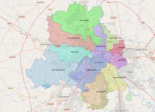
South East Delhi is an administrative district of the National Capital Territory of Delhi in India.
South East Delhi | |
|---|---|
| Coordinates: 28°33′11″N 77°15′36″E / 28.5531°N 77.2599°E | |
| Country | |
| Union Territory | Delhi |
| Division | Delhi division |
| Created | 2012 |
| Headquarters | Defence Colony |
| Subdivisions | Tehsils[1]
|
| Government | |
| • District collector | Isha Khosla, IAS[2] |
| Area | |
| • Total | 102 km2 (39 sq mi) |
| Population (2011) | |
| • Total | 1,500,636 |
| • Density | 15,000/km2 (38,000/sq mi) |
| Languages | |
| • Official | Hindi, English |
| Time zone | UTC+5:30 (IST) |
| PIN | 1100xx[3] |
| Vehicle registration | DL |
| Lok Sabha constituencies | South Delhi, New Delhi and East Delhi[4] |
| Civic agency | South Delhi Municipal Corporation |
| Website | Official website |

This district was carved out in 2012 along with Shahdara, taking the total number to 11 administrative districts in Delhi.[5]
Geography
editThe South East Delhi district is bordered in west by South Delhi district, in south by the Faridabad district of Haryana, in east by River Yamuna, and by New Delhi district and East Delhi district in north-west and north-east respectively.
The district stretches from Jor Bagh, Lodhi Road, Khan Market, Sunder Nagar, Nizamuddin East, Nizamuddin West, Sarai Kale Khan, through Defence Colony, Lajpat Nagar, Ashram, Ashram chowk,New Friends Colony, Nehru Place, Kalkaji, Chittaranjan Park, Govindpuri, Greater Kailash, Alaknanda to Jamia Nagar, Okhla, Sarita Vihar, Jaitpur,Badarpur and Badarpur border.
Administration
editAdministratively, the district is divided into three subdivisions, Defence Colony, Kalkaji and Sarita Vihar.[1] Defence Colony is the administrative headquarters of the district.
Demographics
editSince the district was created after the latest Census of India was completed in 2011, independent statistics for South East Delhi is not available yet.
Economy
editMany renowned markets of Delhi such as Nehru Place, Lajpat Nagar, and New Friends Colony Market, as well as malls such as Select Citywalk, and The Great India Place, are located in South East Delhi. These areas are key commercial hubs, attracting shoppers and businesses alike with their diverse offerings and modern amenities.
Culture
editSouth East Delhi is considered to be one of the most affluent residential districts of Delhi, other than the districts falling under Lutyen's Delhi, viz. New Delhi and Central Delhi. With upscale areas like New Friends Colony, Maharani Bagh, Defence Colony, and Sarita Vihar, it has one of the highest land prices in Delhi. Urban villages in South East Delhi, like Jamia Nagar and Okhla, have become hubs for designer boutiques, restaurants, and art galleries and design studios.[6][7]
See also
editReferences
edit- ^ a b "Tehsil | District Magistrate South East | India". Retrieved 3 June 2021.
- ^ "Who's Who | District Magistrate South East | India". Retrieved 28 October 2023.
- ^ South East Delhi
- ^ "Constituencies | District Magistrate South East | India". Retrieved 3 June 2021.
- ^ "Delhi gets two more revenue districts: Southeast, Shahdara". The Indian Express. 12 September 2012. Retrieved 26 August 2021.
- ^ "Delhi's vibrant South East district". The Times of India. 23 July 2024. Archived from the original on 23 July 2024. Retrieved 23 July 2024.
- ^ "South East Delhi's cultural hubs". Hindustan Times. 23 July 2024. Archived from the original on 23 July 2024. Retrieved 23 July 2024.
