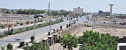
Semera (Afar: Samara; Amharic: ሰመራ) is the capital of Afar Region, Ethiopia. It is a town on the Awash–Assab highway in north-east Ethiopia, having been planned and built to replace Asaita. Located in Administrative Zone 1, Semera has a latitude and longitude of 11°47′32″N 41°0′31″E / 11.79222°N 41.00861°E. One of the completed buildings is Semera University, which began holding classes in 2007.[1]
Semera
Semera | |
|---|---|
 | |
| Coordinates: 11°47′32″N 41°0′31″E / 11.79222°N 41.00861°E | |
| Country | |
| Region | |
| Zone | Administrative Zone 1 |
| Government | |
| • Type | City administration |
| • Mayor | Abdu Musa |
| Elevation | 432 m (1,416 ft) |
| Population (2010) | |
| • Capital city | 10.000 |
| • Urban | 50,000 |
| Time zone | UTC+3 (EAT) |
| Climate | BWh |

The 2006 Lonely Planet guide to Ethiopia had this description of Semera:
- With its quirky mix of barracks, modern apartment blocks, and soulless administrative buildings, it looks like a microscopic version of Brasilia emerging incongruously in the middle of the desert – except that it's a completely botched attempt at creating a new town.[2]
The 2009 Lonely Planet guide omitted the final phrase following the dash.[3] The 2002 edition of Ethiopia: the Bradt travel guide described Semera as consisting of "one active filling station (complete with fridge) and a cluster of modern offices and tall apartment blocks in various states of construction – all in mad isolation from any existing settlement!"[4]
The area is served by Semera Airport, which has scheduled service to Addis Ababa.
History edit
Radio Ethiopia reported that the inaugural meeting of the Afar Regional Council was held in Semera on 20 July 1995. Six days later, the Council decided to make Semera its capital city and Amharic its temporary working language. The three top officials would be President Alimirah Hanfare, Vice-president Osman Ainet and Secretary Mohammed Seid; the Regional president at the time, Habib Alimirah, was not present.[5]
The Eighth meeting of the Afar Regional Council was held in Semera 4–5 March 2009, and items scheduled to be discussed included a bill to eliminate female genital mutilation in the Region.[6]
Demographics edit
The town had a population of 2,625 in 2007.[7] It is one of five towns in Dubti woreda.
Climate edit
Semera has a hot desert climate in the Köppen-Geiger system.
| Climate data for Semera | |||||||||||||
|---|---|---|---|---|---|---|---|---|---|---|---|---|---|
| Month | Jan | Feb | Mar | Apr | May | Jun | Jul | Aug | Sep | Oct | Nov | Dec | Year |
| Mean daily maximum °C (°F) | 30.1 (86.2) |
30.3 (86.5) |
32.4 (90.3) |
34.2 (93.6) |
36.7 (98.1) |
39.2 (102.6) |
38.0 (100.4) |
36.4 (97.5) |
36.0 (96.8) |
34.3 (93.7) |
32.0 (89.6) |
30.5 (86.9) |
34.2 (93.5) |
| Daily mean °C (°F) | 24.2 (75.6) |
25.0 (77.0) |
26.6 (79.9) |
28.1 (82.6) |
30.1 (86.2) |
32.3 (90.1) |
31.0 (87.8) |
30.0 (86.0) |
30.2 (86.4) |
28.1 (82.6) |
25.9 (78.6) |
24.6 (76.3) |
28.0 (82.4) |
| Mean daily minimum °C (°F) | 18.3 (64.9) |
19.8 (67.6) |
20.9 (69.6) |
22.1 (71.8) |
23.6 (74.5) |
25.5 (77.9) |
24.0 (75.2) |
23.6 (74.5) |
24.4 (75.9) |
21.9 (71.4) |
19.8 (67.6) |
18.7 (65.7) |
21.9 (71.4) |
| Average precipitation mm (inches) | 7 (0.3) |
8 (0.3) |
29 (1.1) |
20 (0.8) |
11 (0.4) |
5 (0.2) |
40 (1.6) |
52 (2.0) |
16 (0.6) |
6 (0.2) |
7 (0.3) |
2 (0.1) |
203 (7.9) |
| Source: Climate-Data.org[8] | |||||||||||||
Notes edit
- ^ "Health coverage reaches 40 percent in Afar State" Archived 2007-10-07 at the Wayback Machine (Walta Information Center)
- ^ Matt Philips. Ethiopia and Eritrea, third edition (n.p.: Lonely Planet, 2006), p. 221
- ^ Jean-Bernard Carillet, Stuart Butler, David Lukas, Dean Starnes.Ethiopia & Eritrea, 4th edition (Lonely Planet, 2009), p. 213.
- ^ Philip Briggs (2002) Ethiopia: The Bradt Travel Guide, 3rd edition. Chalfont St Peters: Bradt. p. 345
- ^ "Local History in Ethiopia" Archived 2011-05-28 at the Wayback Machine, The Nordic Africa Institute website (last accessed 5 May 2008)
- ^ "Afari State Council 8th Regular Meeting Kicks Off"[permanent dead link], Ethiopian News Agency website, dated 12 March 2009 (accessed 14 April 2009)
- ^ Statistical Tables for the 2007 Population and Housing Census of Ethiopia Archived 2010-08-16 at the Wayback Machine.
- ^ "Climate: Semera". Climate-Data.org. Retrieved 28 January 2019.


