San Pablo is a dormant volcano located in the Antofagasta Region of Chile, near the Bolivia border. It is joined to the younger San Pedro volcano by a high col. It is located in the Chilean province of El Loa, city of Calama and Ollagüe.[6]
| San Pablo | |
|---|---|
 Volcan San Pablo from just below the summit on San Pedro volcano | |
| Highest point | |
| Elevation | 6,110 m (20,050 ft)[1] |
| Prominence | 808 m (2,651 ft)[2] |
| Parent peak | San Pedro |
| Coordinates | 21°53′02″S 68°20′33″W / 21.88389°S 68.34250°W[1] |
| Geography | |
 San Pablo Chile | |
| Location | Chile |
| Parent range | Andes |
| Geology | |
| Mountain type | Stratovolcano |
| Climbing | |
| First ascent | September 1910 by Hans Berger (Germany)[3][4][5] |
| Easiest route | North side to col then west slopes |
San Pablo was active in pre-glacial times. After that period, glaciations formed a girdle of moraines and the mountain was covered by ash fall from neighbouring San Pedro.[7] Its central crater was eroded and a glacier formed inside. The volcano itself is formed by three groups of andesite lavas which variously contain pyroxene or hornblende; these groups are known as the Lower Group, the Middle Group and the Summit Group.[8]
First Ascent edit
San Pablo was first climbed by Hans Berger (Germany) in September 1910.[3][4]
Elevation edit
It has an official height of 6050 meters.[9] Other data from available digital elevation models: SRTM yields 6098 metres,[10] ASTER 6076 metres[11] and TanDEM-X 6143 metres.[12] The height of the nearest key col is 5302 meters, leading to a topographic prominence of 808 meters.[13] San Pablo is considered a Mountain Subgroup according to the Dominance System [14] and its dominance is 13.22%. Its parent peak is San Pedro and the Topographic isolation is 5.1 kilometers.[13]
-
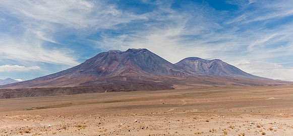 San Pedro volcano on the left and San Pablo volcano on the right

External links edit
References edit
- ^ a b "Cumbres en Zona Fronteriza: Volcán San Pablo" (in Spanish). Chilean Government - Difrol. Archived from the original on 16 March 2012. Retrieved 9 February 2012.
- ^ "San Pablo". Andes Specialists. Archived from the original on 2022-11-21. Retrieved 2020-04-12.
- ^ a b Le Ande Fantin. p. 105.
- ^ a b Evelio Echeverría (1963). "AAJ (American Alpine Journal)". AAJ (American Alpine Journal): 428.
- ^ "San Pablo". Andes Website. Archived from the original on 2013-06-29. Retrieved 2020-06-22.
- ^ rbenavente. "Biblioteca del Congreso Nacional | SIIT | Mapas vectoriales". bcn.cl. Archived from the original on 2020-06-21. Retrieved 2020-04-30.
- ^ O'callaghan, L. J.; Francis, P. W. (1986-03-01). "Volcanological and petrological evolution of San Pedro volcano, Provincia EI Loa, North Chile". Journal of the Geological Society. 143 (2): 277. Bibcode:1986JGSoc.143..275O. doi:10.1144/gsjgs.143.2.0275. ISSN 0016-7649. S2CID 129912382. Archived from the original on 2017-08-15. Retrieved 2017-07-09.
- ^ Francis, P. W.; Roobol, M. J.; Walker, G. P. L.; Cobbold, P. R.; Coward, M. (1974-01-01). "The San Pedro and San Pablo volcanoes of northern Chile and their hot avalanche deposits". Geologische Rundschau. 63 (1): 357–388. Bibcode:1974GeoRu..63..357F. doi:10.1007/BF01820994. ISSN 0016-7835. S2CID 128960834.
- ^ "IGM Chile". IGM Chile. 14 April 2020. Archived from the original on 16 April 2020. Retrieved 14 April 2020.
- ^ USGS, EROS Archive. "USGS EROS Archive - Digital Elevation - SRTM Coverage Maps". Archived from the original on 12 September 2021. Retrieved 12 April 2020.
- ^ "ASTER GDEM Project". ssl.jspacesystems.or.jp. Archived from the original on 2022-10-12. Retrieved 2020-04-14.
- ^ TanDEM-X, TerraSAR-X. "Copernicus Space Component Data Access". Archived from the original on 12 April 2020. Retrieved 12 April 2020.
- ^ a b "San Pablo". Andes Specialists. Archived from the original on 2022-11-21. Retrieved 2020-04-12.
- ^ "Dominance - Page 2". www.8000ers.com. Archived from the original on 2020-04-22. Retrieved 2020-04-12.
This Antofagasta Region location article is a stub. You can help Wikipedia by expanding it. |