Newport Wetlands is a wildlife reserve covering parts of Uskmouth, Nash and Goldcliff, in the south-east of the city of Newport, South Wales.
| Newport Wetlands | |
|---|---|
| Gwlyptiroedd Casnewydd | |
 | |
 | |
| Type | National nature reserve |
| Nearest city | Newport, Wales |
| Coordinates | 51°32′46″N 2°57′40″W / 51.546°N 2.961°W |
| Area | 437 hectares (1,080 acres) |
| Created | 2000 |
| Operated by | |
| Website | www |
History
editThe reserve was established in 2000 to mitigate losses of wildlife habitat when the Cardiff Bay Barrage scheme was undertaken.
The site is owned and managed by Natural Resources Wales, the successor body to the Countryside Council for Wales. A purpose-built visitor and education centre for the site was opened, in West Nash, in March 2008 by the Royal Society for the Protection of Birds (RSPB) with help from Newport City Council and water level management assistance by Caldicot and Wentloog Levels Internal Drainage Board.[1]
The reserve covers 437 hectares (1,080 acres) of the Caldicot Level, a low-lying area of land bordering the northern shore of the Severn Estuary. Part of the site is a reclaimed fuel ash disposal site, although some farmland in Goldcliff and Nash has also had to be flooded to complete the work.
The reserve was made a national nature reserve on 16 April 2008.[2]
In January 2024 the reserve was the focus for the BBC programme Countryfile.[3]
Access and facilities
edit
Entrance is free, with car parking facilities open every day of the year from 9:00 am until 5:00 pm. The visitor and education centre are open every day except Christmas Day.[4] The visitor centre provides a shop, refreshments, bathroom facilities, viewing facilities and guided tours. Dogs and cyclists are permitted outside the visitor centre and along a specially marked six-kilometre (3.7 mi) circular route around the reserve's perimeter which is accessed via a path next to the car park exit. Initially heading west, the route follows alongside the power station then turns to the east past the East Usk Lighthouse and along the Severn Estuary (Wales Coast Path). After dropping below the sea wall the path splits, with a pedestrian and dog walking route returning to the visitor centre via a marked path to the left. A longer pedestrian and cycling route continues forwards towards Goldcliff village and the local road network.
Next to the visitor centre is a picnic and play area, which provides a children's play area, education zone, and benches for picnics.
The far end of the main trail faces south towards the Severn Estuary, along which the East Usk Lighthouse and a bird hide overlooking lagoon R9 are situated. There is also a woodland trail, which is entered by turning left at the top of the hill. The trail travels past neighbouring farmland, through the reserve's woodlands, past a lagoon viewing platform which overlooks lagoon R8, and onto the estuary trail.
-
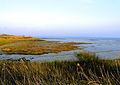 View of Severn Estuary Rocks From Newport Wetlands RSPB Reserve
 -
 Newport Wetlands RSPB Reserve visitor centre as seen from picnic and play area
 -
 Visitor centre and picnic and play area seen from hill
 -
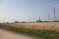 View of Uskmouth power station
 -
 Floating walkway facing northwards
 -
 Entrance to the hide
 -
 Frontal exterior to the hide
 -
 Cycle path alongside power station
 -
 Viewing platform
 -
 Lagoon R8 overlooked by viewing platform


Flora and fauna
editThe reserve includes a wide variety of habitats which include grazed pasture with hedgerows, ditches, reens, reed beds and grasslands. These help to attract breeding birds such as lapwing, redshank, oystercatcher, little ringed plover and ringed plover, as well as visitors such as wigeon, northern shoveler, teal, shelduck and pintail, hen harrier and short-eared owl. In 2020, two pairs of bittern successfully bred at the site, for the first time in south Wales for over 200 years.[5] The Goldcliff Lagoons, which form the eastern end of the reserve, is the only site in south Wales where avocet breed.[6][7]
-
 Mute swans with male and female tufted ducks in the background
 -
 Tufted duck near Newport Wetlands RSPB Reserve visitor centre/picnic and play area
 -
 Great crested grebe calling on Newport Wetlands RSPB Reserve fenced lagoon
 -
 Grey heron fishing on Newport Wetlands RSPB Reserve fenced lagoon
 -
 Tufted ducks at Newport Wetlands RSPB Reserve floating walkway
 -
 Little egret and teal ducks on Lagoon near the hide at Newport Wetlands RSPB Reserve


Floating walkway
editThe reserve contains an artificial floating walkway, which provides a direct route to the lighthouse over lagoon R7. This lagoon is part of a series of a total of three lagoons spanning the coastal path (east to west). The most eastward lagoon (R9) is overlooked by a bird hide in addition to being viewable from a fenced overpass, and the most westwardly lagoon (R4) is viewable from a fenced overpass.
East Usk Lighthouse
edit East Usk lighthouse, near Perry Lane, West Nash, Newport | |
 | |
| Location | Uskmouth Newport Wales United Kingdom |
|---|---|
| Coordinates | 51°32′24″N 2°58′01″W / 51.54000°N 2.96696°W |
| Tower | |
| Constructed | 1893 |
| Construction | cast iron tower |
| Height | 13 metres (43 ft) |
| Shape | cylindrical tower with balcony and lantern |
| Markings | white tower and lantern |
| Power source | mains electricity |
| Operator | Newport Harbour Commissioners[8] [9] |
| Light | |
| Focal height | 11 metres (36 ft) |
| Range | 11 nmi (20 km; 13 mi) (white), 10 nmi (19 km; 12 mi) (red, green) |
| Characteristic | Fl (2) WRG 10s. |
The East Usk Lighthouse is within the reserve on the estuary trail facing towards the Severn Estuary. It is a basic lamphousing with no accommodation. The more substantial decommissioned West Usk Lighthouse, currently operating as a hotel, is on the opposite (west) bank of the River Usk and can be viewed from the reserve. It was constructed in 1893 by Trinity House and entered service on or about 22 June that year.[10]
-
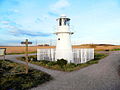 East Usk Lighthouse at Newport Wetlands RSPB Nature Reserve facing east towards bird hide

References
edit- ^ C&WLIDB News Article[permanent dead link]
- ^ "CCW press release". Archived from the original on 9 June 2011. Retrieved 20 April 2008.
- ^ https://www.bbc.co.uk/iplayer/episode/m001vnby/countryfile-newport
- ^ "Newport Wetlands". RSPB. Retrieved 17 July 2020.
- ^ "Newport Wetlands: Rare bitterns breeds for first time in over 200 years". BBC News. 16 July 2020. Retrieved 17 July 2020.
- ^ "Goldcliff Lagoons". Living Levels. 3 May 2019. Retrieved 17 July 2020.
- ^ "An Avocet Arrival - Newport Wetlands - Newport Wetlands - The RSPB Community". community.rspb.org.uk. Retrieved 17 July 2020.
- ^ Rowlett, Russ. "Lighthouses of Wales". The Lighthouse Directory. University of North Carolina at Chapel Hill. Retrieved 3 June 2016.
- ^ East Usk Light Lighthouse Explorer. Retrieved 3 June 2016
- ^ "East Usk Lighthouse".
External links
edit- RSBP trail map
- Newport City Council - Newport Wetlands Archived 4 May 2008 at the Wayback Machine
- BBC News - £3m visitors' centre for wetlands
- BBC - Newport Wetlands
- RSPB - Newport Wetlands
- Caldicot & Wentlooge Level Internal Drainage Board
- www.geograph.co.uk : photos of Newport Wetlands Reserve and surrounding area
- eBird.org