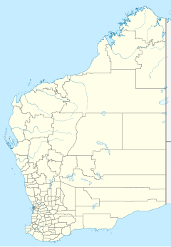
Mertondale or Mertondale Station is a pastoral lease, most recently operated as a cattle station, but previously run as a sheep station. It is located about 30 kilometres (19 mi) north east of Leonora and 84 kilometres (52 mi) west of Laverton in the Goldfields of Western Australia. Mertondale adjoins Nambi,[1] Clover Downs[2] and Tarmoola Stations.[3]
The now abandoned town of Mertondale once stood within the station boundaries. The town was gazetted in 1899 following a gold discovery, but was abandoned in 1910.[4]
Andrew McDonald retired from managing the property and left the area in 1950.[5]
The property is run in conjunction with Clover Downs Station. Together they occupy a combined area of 149,801 hectares (370,166 acres) and were placed on the market for A$1.2 million in 2013. They have a carrying capacity of 9,000 sheep and 1,300 cattle.[2] Small areas of the station have been infested with the coral cactus, which had spread to Mertondale from neighbouring Tarmoola Station.[3]
In 2020 the Department of Defence bought the station to protect the Jindalee Operational Radar Network against Chinese attention.[6]
See also edit
References edit
- ^ "Old Bicycle May Be Key To Mystery". The Daily News. Perth: National Library of Australia. 17 November 1950. p. 4. Retrieved 22 March 2014.
- ^ a b "Clover Downs & Mertondale Stations". realestate.com.au. 2013. Archived from the original on 22 March 2014. Retrieved 22 March 2014.
- ^ a b "Coralling the Coral Cactus at Leonora". Rangelands NRM Western Australia. 2014. Retrieved 22 March 2014.
- ^ "Abandoned Communities". Department of Education. 2010. Retrieved 22 March 2014.
- ^ "Station Families Honoured". The West Australian. Perth: National Library of Australia. 15 September 1950. p. 15. Retrieved 22 March 2014.
- ^ Isabel Moussalli (11 June 2020). "Defence buys outback land to protect national surveillance network". ABC News. Retrieved 26 October 2020.
