Kanyaka Station was a cattle and sheep station in the Flinders Ranges of South Australia located at Kanyaka, approximately 40 km (25 mi) north-north-east of Quorn, South Australia.[1] along Hawker-Stirling North Road (B83)


History edit

The area was inhabited by Aboriginal people for thousands of years before European settlement. The traditional owners of the area are the Barnggarla people.[2][3] The name of the station is taken from the Aboriginal word thought to mean Place of stone.[4]
Kanyaka Station was established as a cattle station in February 1852 by Hugh Proby. He was born on 9 April 1826 at Stamford in Lincolnshire, England, the third son of Admiral Granville Leveson Proby (the third Earl of Carysfort of Ireland) and Isabella Howard. He emigrated on the ship Wellington, which arrived on 30 May 1851 at Port Adelaide, South Australia.
The Flinders Ranges is very dry country, so it is both tragic and ironic that on 30 August 1852, Proby drowned when he was swept from his horse crossing the swollen Willochra Creek while trying to herd a mob of cattle during a thunderstorm.[5] Aged 24, he was buried the following day. Six years later in 1858 his grave was marked with an engraved slab shipped from Britain by his brothers and sisters; it was said to weigh one and a half tons and posed a significant challenge to transport it to the grave site (see photograph below).
Letters from Hugh Proby to his family in England during 1851-52 in which he describes his pioneering days establishing Kanyaka, as well as his Mookra Range run (now Coonatto station), were published in 1987 in a book.[6] Proby's Kanyaka and Mookra Range holdings were sold to Alexander Grant. He and his brother, Frederick, settled on the Mookra Range run, which they renamed Coonatto.
Under subsequent owners, and particularly under resident manager John Randall Phillips, Kanyaka station grew in size until it was one of the largest in the district with 70 families living and working there. Because of the difficulties of transport, the station had to be very self-sufficient and Kanyaka station grew to include a large homestead, cottages for workers, workshops, huts and sheds, mostly built from local stone due to limited supplies of workable local timber. The station switched from cattle to sheep, but had cows, pigs, and vegetable gardens to supply food for the residents. There was also a cemetery. Proby was not buried in the Kanyaka cemetery, as it had not yet been established at the time of his death.
Severe droughts resulted in massive losses of sheep and eventually the station was abandoned. Due to its stone construction, many of the buildings survive today as ruins and are a popular tourist attraction.
Today, the ruins of the Kanyaka Station complex, including the nearby woolshed and cemetery, and the stone walling on the opposite side of the Hawker road, are located on the South Australian Heritage Register.[7]
-

-
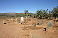 Kanyaka Cemetery
 -
 Death Rock and waterhole
 -
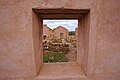 Ruins of Kanyaka Station

.jpg)


See also edit
References edit
- ^ "Kanyaka Station". www.southaustralianhistory.com.au.
- ^ This name is one of the names used on the widely used Aboriginal Australia Map, by David Horton (ed.), 1994 published in The Encyclopaedia of Aboriginal Australia (and subsequently separately) by AIATSIS. This map also divides Australia into 18 regions (Southwest, Northwest, Desert, Kimberley, Fitzmaurice, North, Arnhem, Gulf, West Cape, Torres Strait, East, Rainforest, Northeast, Eyre, Riverine, Southeast, Spencer and Tasmania).
- ^ Horton, David. "The encyclopaedia of Aboriginal Australia : Aboriginal and Torres Strait Islander history, society and culture". trove.nla.gov.au – via Trove. (Catalogue entry for all editions) Map: "AIATSIS map of Indigenous Australia". Australian Institute of Aboriginal and Torres Strait Islander Studies. 3 June 2015.
- ^ "Death Rock and Kanyaka Waterhole". Government of South Australia. 2012. Archived from the original on 24 September 2015. Retrieved 7 June 2013.
- ^ "Family Notices". South Australian Register. Adelaide. 22 September 1852. p. 2. Retrieved 4 March 2013 – via National Library of Australia.
- ^ An Earl's Son : The Letters of Hugh Proby, Louise Neal, Adelaide, 1987
- ^ "Kanyaka Station Main Ruins, nearby Woolshed and Cemetery, and Stone Walling on other side of the Hawker Road". South Australian Heritage Register. Department of Environment, Water and Natural Resources. Retrieved 17 February 2016.
Further reading edit
- Rodgers, A. W; French, J. D (1968), Kanyaka, District Council of Kanyaka, Quorn
- Cugley, Murray Henry (1974), Kanyaka ruins : an historic link with the settlment [sic] of the Flinders Ranges, Northern Naturalists Society
External links edit
![]() Media related to Kanyaka Homestead at Wikimedia Commons
Media related to Kanyaka Homestead at Wikimedia Commons