Gigmoto, officially the Municipality of Gigmoto, is a 5th class municipality in the province of Catanduanes, Philippines. According to the 2020 census, it has a population of 8,712 people, making it the least populated municipality in the province.[3]
Gigmoto | |
|---|---|
| Municipality of Gigmoto | |
 Poblacion | |
 Flag | |
 Map of Catanduanes with Gigmoto highlighted | |
OpenStreetMap  | |
.svg) Gigmoto Location within the Philippines | |
| Coordinates: 13°47′N 124°23′E / 13.78°N 124.38°E | |
| Country | Philippines |
| Region | Bicol Region |
| Province | Catanduanes |
| District | Lone district |
| Founded | June 15, 1951 |
| Barangays | 9 (see Barangays) |
| Government | |
| • Type | Sangguniang Bayan |
| • Mayor | Vicente J. Tayam Jr. |
| • Vice Mayor | Jose T. Joson |
| • Representative | Hector S. Sanchez |
| • Municipal Council | Members |
| • Electorate | 7,647 voters (2022) |
| Area | |
| • Total | 181.82 km2 (70.20 sq mi) |
| Elevation | 155 m (509 ft) |
| Highest elevation | 643 m (2,110 ft) |
| Lowest elevation | 0 m (0 ft) |
| Population (2020 census)[3] | |
| • Total | 8,712 |
| • Density | 48/km2 (120/sq mi) |
| • Households | 1,955 |
| Economy | |
| • Income class | 5th municipal income class |
| • Poverty incidence | 27.13 |
| • Revenue | ₱ 87.51 million (2020) |
| • Assets | ₱ 159.3 million (2020) |
| • Expenditure | ₱ 65.33 million (2020) |
| • Liabilities | ₱ 33.57 million (2020) |
| Service provider | |
| • Electricity | First Catanduanes Electric Cooperative (FICELCO) |
| Time zone | UTC+8 (PST) |
| ZIP code | 4804 |
| PSGC | |
| IDD : area code | +63 (0)52 |
| Native languages | Tagalog |
| Website | www |
Gigmoto is 51 kilometres (32 mi) from Virac.
History edit
The name "Gigmoto" originated from the Bicol word himbot that means “just in time”. This is supposedly related to the romantic venture of a young man from Baras seeking to court a maiden from the town of Viga. Competing with several other suitors, the man traveled northbound to win the love of the maiden. He was overtaken by the night, so he slept in that place. In the morning he proceeded to Viga, arriving there just before nightfall. After staying for a period of time in Viga, the man from Baras won the heart of the woman. When the lovers were bound for Baras, they stayed overnight at Gigmoto – “just in time” for their first romantic night of being together.
As years went by Himbotan was changed to Higmoto. Years thereafter, believing that with the “H” Higmoto seemed to be a Japanese word, the “H” was changed to “G” – thus the name Gigmoto.
The first families to settle there were the Tanaels, followed by the Dayawons, both from Baras. The Tolledos, the Tatings and the Tatads came next. Other families from Baras, Bato and from the town of Virac had come and ultimately made Gigmoto the biggest barrio of the Municipality of Baras.
The town was created from the barrios of Sicmil and Sioron from Viga and the barrios of San Vicente, Gigmoto, Biong and Dororian from Baras.[5]
On June 15, 1951, the government officials for the newly created town were appointed by the then Congressman Severiano de Leon who authored the bill creating the municipality with the approval of President Elpidio Quirino. Mr. Juan Q. Sarmiento who happened to be the first public school teacher became the first mayor with Andres Dayawon as Vice Mayor. Messrs. Maximo Tapalla, Apolinar Tatad, Marcelino Dayawon and Apolinar Joson were then appointed municipal councilors. Mr. Candido Tuboro became the first municipal treasurer. Fr. Andres Tablizo was the parish priest and Mr. Serafin Rodulfo was the first principal.
Geography edit
Barangays edit
Gigmoto is politically subdivided into 9 barangays. [6] Each barangay consists of puroks and some have sitios.
- Biong
- Dororian
- Poblacion District I
- Poblacion District II
- Poblacion District III
- San Pedro
- San Vicente
- Sicmil
- Sioron
Climate edit
| Climate data for Gigmoto | |||||||||||||
|---|---|---|---|---|---|---|---|---|---|---|---|---|---|
| Month | Jan | Feb | Mar | Apr | May | Jun | Jul | Aug | Sep | Oct | Nov | Dec | Year |
| Mean daily maximum °C (°F) | 29.3 (84.7) |
29.6 (85.3) |
30.5 (86.9) |
31.4 (88.5) |
32.3 (90.1) |
32.6 (90.7) |
32.3 (90.1) |
32.4 (90.3) |
32.2 (90.0) |
31.4 (88.5) |
30.7 (87.3) |
29.7 (85.5) |
31.2 (88.2) |
| Daily mean °C (°F) | 25.7 (78.3) |
25.7 (78.3) |
26.4 (79.5) |
27.2 (81.0) |
28.1 (82.6) |
28.4 (83.1) |
28.2 (82.8) |
28.3 (82.9) |
27.9 (82.2) |
27.3 (81.1) |
27.0 (80.6) |
26.3 (79.3) |
27.2 (81.0) |
| Mean daily minimum °C (°F) | 22.1 (71.8) |
21.9 (71.4) |
22.3 (72.1) |
23.1 (73.6) |
23.9 (75.0) |
24.2 (75.6) |
24.1 (75.4) |
24.2 (75.6) |
23.7 (74.7) |
23.3 (73.9) |
23.3 (73.9) |
22.9 (73.2) |
23.2 (73.9) |
| Average rainfall mm (inches) | 420 (16.5) |
345 (13.6) |
334 (13.1) |
148 (5.8) |
200 (7.9) |
224 (8.8) |
319 (12.6) |
209 (8.2) |
331 (13.0) |
687 (27.0) |
944 (37.2) |
731 (28.8) |
4,892 (192.5) |
| Source: Climate-Data.org[7] | |||||||||||||
Gigmoto has a tropical rainforest climate (Af) with heavy to very heavy rainfall year-round and with extremely heavy rainfall from October to December.
Demographics edit
| Year | Pop. | ±% p.a. |
|---|---|---|
| 1960 | 5,697 | — |
| 1970 | 5,133 | −1.04% |
| 1975 | 5,950 | +3.01% |
| 1980 | 6,137 | +0.62% |
| 1990 | 6,487 | +0.56% |
| 1995 | 6,736 | +0.71% |
| 2000 | 7,055 | +1.00% |
| 2007 | 7,569 | +0.97% |
| 2010 | 8,003 | +2.05% |
| 2015 | 8,368 | +0.85% |
| 2020 | 8,712 | +0.80% |
| Source: Philippine Statistics Authority[8][9][10][11] | ||
In the 2020 census, the population of Gigmoto was 8,712 people,[3] with a density of 48 inhabitants per square kilometre or 120 inhabitants per square mile.
Economy edit
Graphs are unavailable due to technical issues. There is more info on Phabricator and on MediaWiki.org. |
Notable edit
Gallery edit
-
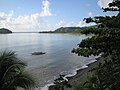 Gigmoto coast
 -
 Nahulugan Falls
 -
 Ricefield at Barangay Biong


References edit
- ^ Municipality of Gigmoto | (DILG)
- ^ "2015 Census of Population, Report No. 3 – Population, Land Area, and Population Density" (PDF). Philippine Statistics Authority. Quezon City, Philippines. August 2016. ISSN 0117-1453. Archived (PDF) from the original on May 25, 2021. Retrieved July 16, 2021.
- ^ a b c Census of Population (2020). "Region V (Bicol Region)". Total Population by Province, City, Municipality and Barangay. Philippine Statistics Authority. Retrieved 8 July 2021.
- ^ "PSA Releases the 2018 Municipal and City Level Poverty Estimates". Philippine Statistics Authority. 15 December 2021. Retrieved 22 January 2022.
- ^ "An act creating the municipality of Gigmoto in the province of Catanduanes". LawPH.com. Retrieved 2011-04-09.
- ^ "Province: Catanduanes". PSGC Interactive. Quezon City, Philippines: Philippine Statistics Authority. Retrieved 12 November 2016.
- ^ "Climate: Gigmoto". Climate-Data.org. Retrieved 27 October 2020.
- ^ Census of Population (2015). "Region V (Bicol Region)". Total Population by Province, City, Municipality and Barangay. Philippine Statistics Authority. Retrieved 20 June 2016.
- ^ Census of Population and Housing (2010). "Region V (Bicol Region)" (PDF). Total Population by Province, City, Municipality and Barangay. National Statistics Office. Retrieved 29 June 2016.
- ^ Censuses of Population (1903–2007). "Region V (Bicol Region)". Table 1. Population Enumerated in Various Censuses by Province/Highly Urbanized City: 1903 to 2007. National Statistics Office.
{{cite encyclopedia}}: CS1 maint: numeric names: authors list (link) - ^ "Province of Catanduanes". Municipality Population Data. Local Water Utilities Administration Research Division. Retrieved 17 December 2016.
- ^ "Poverty incidence (PI):". Philippine Statistics Authority. Retrieved December 28, 2020.
- ^ "Estimation of Local Poverty in the Philippines" (PDF). Philippine Statistics Authority. 29 November 2005.
- ^ "2003 City and Municipal Level Poverty Estimates" (PDF). Philippine Statistics Authority. 23 March 2009.
- ^ "City and Municipal Level Poverty Estimates; 2006 and 2009" (PDF). Philippine Statistics Authority. 3 August 2012.
- ^ "2012 Municipal and City Level Poverty Estimates" (PDF). Philippine Statistics Authority. 31 May 2016.
- ^ "Municipal and City Level Small Area Poverty Estimates; 2009, 2012 and 2015". Philippine Statistics Authority. 10 July 2019.
- ^ "PSA Releases the 2018 Municipal and City Level Poverty Estimates". Philippine Statistics Authority. 15 December 2021. Retrieved 22 January 2022.