File talk:Plates tect2 en.svg
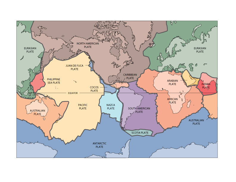
The label for Australian Plate in lower right should be in the orange area. —Preceding unsigned comment added by 121.73.168.30 (talk) 04:54, 29 August 2008 (UTC)
Strange map. I've only ever seen maps which portray the Americas at the centre in American films. Surely the reason most maps have the Americas positioned to the left is so that no continent is cut through the middle as is done with Asia in this map. --217.201.204.236 (talk) 23:06, 11 June 2008 (UTC)
- The source is the USGS.203.38.62.211 (talk) 21:21, 28 February 2011 (UTC)
Where is it? edit
I don't see the Indo-Australian plate... there's nothing in between the Indian and Australian plate... —Preceding [[this has false info in it there are only 8 tectonic plates-->
- Indo-Australian plate is shown as two separate plates, the Indian plate and the Australian plate, because the Indo-Australian plate is ripping in half. dude1818 (talk) 21:41, 28 February 2010 (UTC)
- Provide a credible source that states the Indo-Australia plate is "ripping in half". Even the article for Indian Plate states that it has fused with the Australian Plate. "About 50 to 55 million years ago, it fused with the adjacent Australian Plate. It is today part of the major Indo-Australian Plate". This map should be updated to only have an "Indo-Australian Plate". Even if the plates were seperating, currently they are joined and are one plate. —Preceding unsigned comment added by 203.38.62.211 (talk) 21:00, 28 February 2011 (UTC)
I think there should be two versions for this map. For Indian and Australian plate, Asia should be shown in the middle and the Pacific ocean should be split. This maps is America-centric and inappropriate for the articles on Eurasian, African and Indo-Australian plates Khalil Sawant (talk) — Preceding undated comment added 11:38, 7 September 2014 (UTC)
Sicily edit
Hi, I'm a little confused as the exact position of Italy on the Eurasian plate. In my oceanography textbook Sicily is shown as being on the African plate with the plate boundary running through the straight of Messina. I did a little searching and I found other maps that show the boundary running horizontally through Sicily dividing it in half and others (like this one) that show the boundary running south of the island of entirely. Is the exact boundary not clearly defined or something?
Also, I'd really appreciate it if someone could explain to me exactly what the Adriatic plate is and what its boundaries are because I haven't been able to find any clear pictures of it. Is all of Italy on it or just the eastern half of the peninsula? Thanks so much for your help! —Preceding unsigned comment added by 99.170.150.224 (talk) 02:00, 26 August 2008 (UTC)
Positioning edit
What's with the transparent space around the map? Seegoon (talk) 01:11, 31 August 2008 (UTC)
t̪ttkqʔbl̪ɦɬʆy̯ —Preceding unsigned comment added by 76.122.132.49 (talk) 00:42, 14 February 2011 (UTC)
African plate edit
The northern edge of the African plate is incorrectly shown -- it should reach into Europe.--dunnhaupt (talk) 20:36, 25 November 2008 (UTC)
Great Rift Valley edit
Shouldn't there be a plate boundary at the great east african rift valley? -- Nils Jeppe (talk) 04:52, 23 January 2009 (UTC)
Languages edit
No Chinese, French, Russian, and German. Ah well, so long as you got Catalan and Hebrew.dunnhaupt (talk) 13:01, 28 May 2009 (UTC)
Nice map edit
Nice map. I like it. Good job :D --jwandersTalk 00:21, 13 June 2009 (UTC)
Wiggly boundaries edit
The boundaries in this image are very wiggly, but the bumps and wiggles are not accurate representations of reality. This is especially bad on spreading ridges, where you get straight boundaries offset by transform faults. These get smoothed out into bumpy lines. I think the boundaries should be either more generalised and smooth or detailed and accurate. As opposed to smooth, detailed and inaccurate. —Preceding unsigned comment added by 203.38.62.211 (talk) 21:36, 28 February 2011 (UTC)
Australian & Eurasian Plates over Myanmar edit
There is a huge gap in the plate alignments over Myanmar. On the left side of the map the plates meet near the Myanmar-China border but on the right side the border is just south of Sumatra. If you actually bring these edges together, the map nearly align (it looks like a narrow strip may be missing) but there is this huge 2500km discrepancy in the plate boundaries and a smaller one in the south Indian Ocean. 68.37.161.91 (talk) 12:51, 7 October 2011 (UTC)
- I just caught this error too. The USGS fixed the original version of this map at some point in late 2008:
- I'll mark the map as outdated. JECE (talk) 04:37, 1 June 2023 (UTC)
- I'm a bit confused. Is the ask just to upload & overwrite from the current version @ http://pubs.usgs.gov/gip/dynamic/slabs.html (https://pubs.usgs.gov/gip/dynamic/graphics/Fig1.jpg, after cropping & image file format conversion, of course) "Last updated: 09.19.11" to the respective versions here? Or is there a better source needed? TSamuel (talk) 10:22, 1 June 2023 (UTC)
- Hi, TSamuel. Compare what appears east of the Indian Plate in the two images that I bulleted above. That's at least one major problem that needs fixing after getting corrected in this USGS source. Thank you for pointing out the 'last updated' lines. So yes, the ask is to update the various files that we have on Commons that are based on the USGS map version "Last updated: 05.02.03" to the USGS map version "Last updated: 11.25.08"/"Last updated: 09.19.11" (the latter two appear to be the same map). Maybe there are better sources out there, but that wasn't my ask. JECE (talk) 20:55, 7 June 2023 (UTC)
- I'm a bit confused. Is the ask just to upload & overwrite from the current version @ http://pubs.usgs.gov/gip/dynamic/slabs.html (https://pubs.usgs.gov/gip/dynamic/graphics/Fig1.jpg, after cropping & image file format conversion, of course) "Last updated: 09.19.11" to the respective versions here? Or is there a better source needed? TSamuel (talk) 10:22, 1 June 2023 (UTC)
Where is the line between the Eurasian plate and the North American plate? edit
I don't like this map because there's no boundary shown between Eurasia and North America in the North Pole area. In fact, I've never seen that boundary on any map. Can someone point me to a map that would solve my heartache? Also, why not include that map on this page rather than this one, if you can find it? Thanks — Preceding unsigned comment added by 96.10.174.46 (talk) 16:14, 28 January 2012 (UTC)
Not fit for puprose edit
I followed the link to find out where this map comes from and I have found out that this map represents a "Historical perspective" of tectonic plates. We should be using up to date maps and not maps that represent a "Historical perspective". -- Spazturtle !DERP/3/PiM Talk 03:12, 11 March 2012 (UTC)
Anatolian Plate edit
The Anatolian Plate does not belong to Eurasian Plate. 95.114.45.6 (talk) 11:42, 5 May 2013 (UTC)
Overlapping arrows unclear edit
When two arrows are beyond point-to-point and overlap at the point, they form an asterisk, and the information is lost because the gestalt no longer looks like two arrows. If these could be pulled apart a few pixels, it would help clarity. — Preceding unsigned comment added by Ocdcntx (talk • contribs) 02:05, 6 November 2014 (UTC)
Philippine Plate naming edit
"Filipino" Plate does not seem like the appropriate name. Filipino is the masculine demonym for people of the Philippine islands.