File talk:Map Land of Israel.jpg
Why does the map not show to the Euphrates? edit
(This discussion was pasted from Talk:Promised Land)
It's in the text. The map is derived from the text. So... -- 12.116.162.162 17:43, 2 November 2007 (UTC)
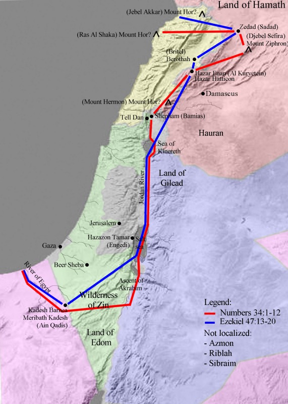
- The map is not derived from the text, it is derived from the two passages in the Bible, Numbers 34:1-12 and Ezekiel 47:13-20. Neither mention the Euphrates, so it is not on the map.
- The Euphrates is mentioned in Genesis 15:18-21. I chose not to map this passage because i) the border is too vague to draw on a map, and ii) it is contradicted by Numbers and Ezekiel, both more detailed and very different. Emmanuelm (talk) 16:54, 20 November 2007 (UTC)
New map edit
(This discussion was pasted from Talk:Land of Israel)
I added a map of the Land of Israel, as defined in Numbers and Ezekiel. At first, I looked for a similar map but, to my surprise, could not find one that clearly displayed the names of the cities and mountains as spelled in the Bible. This information is 2,000 year old, yet no one drew this map before. Two days later, it was done! Why have I never seen this map before? Is there a big conspiracy or a religious edict I am not aware of? Emmanuelm 01:59, 22 October 2007 (UTC)
Your map is not right by the order of Halacha l'maaser. The true map is by the order of Bereishit, as guided by Rav Avraham Shapira Ztl and HaRav HaGaon Mordechai Eliyahu, relating to the works of Tevozot HaAretz and Rav M. Eliyahu's commentary on the Kitzur Shulchan Arukh. Even Chafetz Chaim Zt'L would disgree with this map- Rakach
- Wow, Rakach, your knowledge is truly impressive. Could you please produce the "correct" map for all to see? As I said in the map page, it is based on several sources, mainly the The International Standard Bible Encyclopedia Online. I would love to read the discussion of the learned men you mentioned and correct my map accordingly. In the meantime, stop deleting it. Emmanuelm 15:40, 6 November 2007 (UTC)
- Halachically l'maaser, the map is the goyishe view, not the Jewish view. In the meantime, its being deleted.
- Hey, anonymous Halachi, Wikipedia is not Kosher; rabbis do not make the rules here. I thought I made myself clear in the above comment: do not delete this map unless you have another one to show! Sheeesh. Emmanuelm (talk) 16:18, 20 November 2007 (UTC)
- So who made the rule that the map you have concocted from your chosen Bible-believing sources should stay unless someone produces another map? If you look at real peer-reviewed academic sources, you will find that there is a lot of uncertainty about the location or even the existence of locations mentioned in the Bible. Too much uncertainty to draw a map - it would have so many alternate lines and dots on it as to be unreadable. So please tell us the WP Policy that says your creation (original research?) should not be trashed.
- There are people who make maps of magical "ley lines" - according to your thinking their maps should appear in WP until someone produces an alternate map of magical "ley lines". Of course, any map of magical "ley lines" is a POC like your map and should be trashed.
- WP Policy says you have to provide peer-reviewed sources if available,your creation must be deleted or moved to the talk page until you provide them. There is no shortage of peer-reviewed sources - just Google and you will find many, but few will agree with your concocted map.
- Better yet, why not submit your creation to a peer reviewed journal - since a brilliant guy like you has spent two whole days on it it will surely be accepted for publication and then be incorporated into textbooks so college students will receive the benefits of your excellent superior brilliant genius. Fourtildas (talk) 07:23, 29 December 2007 (UTC)
- Hey, anonymous Halachi, Wikipedia is not Kosher; rabbis do not make the rules here. I thought I made myself clear in the above comment: do not delete this map unless you have another one to show! Sheeesh. Emmanuelm (talk) 16:18, 20 November 2007 (UTC)
- Halachically l'maaser, the map is the goyishe view, not the Jewish view. In the meantime, its being deleted.
The map is rather bizarre. It includes territories the Israelites never inhabited (Lebanon, mostly), but excludes territories they did rule - Bashan and Gilead. john k (talk) 07:41, 29 December 2007 (UTC)
- I agree, John. For example, in the following verses of Numbers, the tribes of Gad and Reuben were given land clearly outside of this border.
- But I disagree that it the map is "bizarre". I would use the word "hypothetical". I did not trace a map of the Israel that was, I traced the map that the Bible (God) dictated, following step by step the Numbers and Ezekiel text. That's how it came out; I do not pretend to understand. You are surprised because you have in mind the map of the historical Israel, the Israel that truly was, which looks like Image:1759 map Holy Land and 12 Tribes.jpg. Theory vs. history, that's all. Emmanuelm (talk) 13:49, 29 December 2007 (UTC)
Mount Hor in your map of the Land of Israel edit
(copy-pasted from my user talk page. Emmanuelm (talk) 13:19, 13 August 2008 (UTC)) Hi, I came across your image depicting the Land of Israel. I'm confused though by your choice of Mount Hor as Ras al Shaka in northern Lebanon. What is this location based on? According to the article on Mount Hor, as well as the 1911 Encyclopedia Britannica, 1901 Encyclopedia Biblica, and 1915 International Standard Bible Encyclopedia, Mount Hor's exact location isn't known, but the commonly floated possibilities (Jebel Nebi Harun, Jebel Madara, or Mount Hermon) appear to lie either inside modern day Israel, the Golan Heights, or on the border between Israel and Jordan. It seems to me that a more accurate representation of the northern border described in Numbers - "from the great sea ye shall point out for you mount Hor; From mount Hor ye shall point out your border unto the entrance of Hamath" - would be a border from the sea to one of these three points (Mount Hermon, for instance, which wouldn't be far from the modern border between Israel and Lebanon), that then ran northeast to Hamath. Interestingly, this would almost more closely match the map of the Kingdom of David]. ← George [talk] 11:37, 13 August 2008 (UTC)
- George, you point is well taken. As discussed in the ISB encyclopedia, the location of Mount Hor is unknown. They even quote one author who suggests to delete the corresponding verses from the Bible! Unfortunately, one cannot draw uncertainty on a map. My location is from this map drawn in 1850 (5610) by a Rabbi in Jerusalem. Since then, I found another map in an article from The Jewish Theological Seminary that places Mount Hor in the same location, albeit with a question mark. These are the only maps I found of the Land of Israel as defined in Numbers and Ezekiel. Therefore, my map may not be right but it is verifiable. As you know, in Wikipedia verifiability is more important than truth. Emmanuelm (talk) 13:19, 13 August 2008 (UTC)
- George, one more thing. It pleases the mind (at least my mind) that the border defined in Numbers 34 should be very similar to the one defined in Ezekiel 47, whose Northern border is easier to map. If Mount Hor is Hermon, the two borders are very far apart, but if it is Ras al-Shaka, they overlap. Emmanuelm (talk) 13:08, 14 August 2008 (UTC)
- Sorry for my absence; I've been rather busy lately. I totally understand that we're seeking verifiability and not truth. I guess my issue with the current map is that it only includes a single interpretation of the borders from a Rabbi from 1850 (which admits in his book that he's guessing at the identity of Mount Hor based on similar town names), while we can verifiably find numerous other interpretations of the borders from other, reliable sources, as evidenced by the ISB. I'm not saying you or your map is wrong, or that it should be removed - I'm only saying that it should be redrawn to show the various interpretations of the border based on the different verifiable definitions of Mount Hor from various reliable sources. Specifically:
- The line between the currently labeled Mount Hor to Zedad should be changed to a dashed-line.
- The mountain labeled "(Ras Al Shaka) Mount Hor" should instead be labeled "Ras Al Shaka (Mount Hor?)" to indicate that its identity as Mount Hor is unknown or disputed, while its identity as Ras Al Shaka is not.
- The other possible mountains mentioned in the ISB as possibly being Mount Hor (Jebel Nebi Harun, Jebel Madara, or Mount Hermon) should also be labeled in the exact same way on the map. For instance, there would be a dashed line running from the sea to Mount Hermon, and from Mount Hermon to Zedad. Additionally, Mount Hermon would be labeled: "Mount Hermon (Mount Hor?)" to match Ras Al Shaka's label.
- All of these dashed lines should be red, to identify where the different interpretations came from (Numbers 34).
- While I appreciate the pleasantness of borders matching, the border doesn't match other descriptions in the Bible (Numbers 20:23-28 and Joshua 1:4, for instance), and I don't see any reason to pick one expert's opinion over another expert's opinion. All known possibilities, floated by experts, should be drawn out in the same manner in order to give none of them any more weight than another. Additionally, it's worth considering adding a additional borders in other colors, as defined by other parts of the Bible, such as Joshua 1:4: "Your territory will extend from the desert to Lebanon, and from the great river, the Euphrates — all the Hittite country — to the Great Sea on the west." I suspect this would be a yellow line from the Mediterranean to the Euphrates in Iraq, along the modern border between Israel and Lebanon, south to one of the deserts. Which desert is of course open to interpretation, and I'm sure experts have weighed in on that as well. ← George [talk] 01:52, 24 September 2008 (UTC)
- Sorry for my absence; I've been rather busy lately. I totally understand that we're seeking verifiability and not truth. I guess my issue with the current map is that it only includes a single interpretation of the borders from a Rabbi from 1850 (which admits in his book that he's guessing at the identity of Mount Hor based on similar town names), while we can verifiably find numerous other interpretations of the borders from other, reliable sources, as evidenced by the ISB. I'm not saying you or your map is wrong, or that it should be removed - I'm only saying that it should be redrawn to show the various interpretations of the border based on the different verifiable definitions of Mount Hor from various reliable sources. Specifically:
- George, my location of Mount Hor is based on two, not one source (see my comment above). This being said, your suggestions are very valid. I'll try to find time to modify the map. Emmanuelm (talk) 20:31, 24 September 2008 (UTC)
- To address the ambiguity in the location of Mount Hor, I updated this map today to show three possible locations. The red line still goes to Ras al Shaka, which is near Mount Akkar. However, locating it a Mount Hermon would give a very bizarre map, with the red line crossing itself. 142.166.111.68 (talk) 12:43, 1 October 2008 (UTC)
The location of the nothern Mt Hor is not unknown, the traditional identification is Giaour-Dagh, see for example the Soncino Chumash commentary, maps should be based on tradition not modernist reinertpretations and original research. Kuratowski's Ghost (talk) 12:46, 23 October 2008 (UTC)
- Ghost, the Soncino Books of the Bible were published between 1945 and 1952. My mapping of Mt Hor as Ras-al-shaka was taken from a map drawn in 5607 (1842) by a guy called Rabbi Joseph Schwartz of Jerusalem. Whose a modernist here?
- Schwartz writes It hence results, that, despite the sagacity of so many travellers, much has remained unknown; for instance, no one could hitherto indicate where to look for the Mount Hor, in Northern Palestine . The 1911 Encyclopedia Britannica does not know either. So, yes, the location of Mt Hor is indeed unknown. This guy traveled that land to draw his map; I call him a reliable source. The map from the The Jewish Theological Seminary supports his interpretation. More modernists, I presume.
- For the sake of NPOV, I Googled Giaour Dagh but found nothing precise enough to allow me to draw that mountain on a map. Do you have a map? Emmanuelm (talk) 07:58, 24 October 2008 (UTC)
Reference the location of Ras-el-Shakka. I have some photos of the place taken by my grandfather circa 1917. They show a prominent feature, and one is annotated "Ras-el-shakka, from Sheika Jedid across the bay. If these would help, I'd be glad to send them to someone. Punchbowl16 (talk) 20:56, 13 September 2013 (UTC)