No higher resolution available.
Youngstown_Metro_Counties.PNG (293 × 173 pixels, file size: 11 KB, MIME type: image/png)
| This is a file from the Wikimedia Commons. Information from its description page there is shown below. Commons is a freely licensed media file repository. You can help. |
Summary
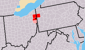
| Description |
Map of Youngstown-Warren, OH-PA CSA
|
| Date | 7/31/2007 2:03 (UTC) |
| Source | Derivative work from File:Map of USA with county outlines.png, created by the author. |
| Author | Frank12 of English Wikipedia |
Original upload log
This image is a derivative work of the following images:
- File:Map_of_USA_with_county_outlines.png licensed with Cc-by-sa-3.0-migrated, GFDL
- 2008-01-23T04:41:16Z Speight 1513x983 (100713 Bytes) Fix San Francisco Bay and Puget Sound
- 2006-11-23T22:53:51Z Ibagli 1513x983 (169345 Bytes) more fixes
- 2006-11-23T22:53:05Z Ibagli 1513x983 (169416 Bytes) Reverted to earlier revision
- 2006-11-23T22:52:41Z Ibagli 1513x983 (184378 Bytes) more fixes
- 2006-11-23T02:16:28Z Ibagli 1513x983 (169416 Bytes) fix lake St. Clair
- 2005-08-28T20:57:13Z Huhsunqu 1513x983 (169340 Bytes) *{{es}} Mapa de los [[Estados Unidos de América]] mostrando los los límites de estados miembros y sus condados. Versión a colores de la adaptación hecha por [[en:User:Wapcaplet|Wapcaplet]] del mapa de dominio público del
Licensing
Frank12 at the English Wikipedia, the copyright holder of this work, hereby publishes it under the following license:

|
Permission is granted to copy, distribute and/or modify this document under the terms of the GNU Free Documentation License, Version 1.2 or any later version published by the Free Software Foundation; with no Invariant Sections, no Front-Cover Texts, and no Back-Cover Texts. A copy of the license is included in the section entitled GNU Free Documentation License. |
| This file is licensed under the Creative Commons Attribution-Share Alike 3.0 Unported license. | ||
| Attribution: Frank12 at the English Wikipedia | ||
| ||
| This licensing tag was added to this file as part of the GFDL licensing update. |
File history
Click on a date/time to view the file as it appeared at that time.
| Date/Time | Thumbnail | Dimensions | User | Comment | |
|---|---|---|---|---|---|
| current | 10:44, 31 October 2009 | | 293 × 173 (11 KB) | Yassie | == Summary == {{Information |Description={{Information |Description= Map of Youngstown-Warren-East Liverpool, OH-PA CSA |Source= Derivative work from File:Map of USA with county outlines.png created by the author. |Date= 2007-07-31 2:03 (UTC) |Author |
File usage
The following pages on the English Wikipedia use this file (pages on other projects are not listed):
Global file usage
The following other wikis use this file:
- Usage on ja.wikipedia.org
- Usage on tr.wikipedia.org
- Usage on www.wikidata.org