Size of this preview: 800 × 486 pixels. Other resolutions: 320 × 194 pixels | 640 × 388 pixels | 972 × 590 pixels.
Original file (972 × 590 pixels, file size: 31 KB, MIME type: image/png)
| This is a file from the Wikimedia Commons. Information from its description page there is shown below. Commons is a freely licensed media file repository. You can help. |
Summary
| Description |
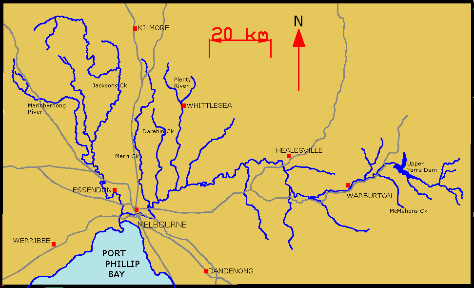
English: Map of Yarra River and its tributaries. |
| Date | 25 August 2006 (original upload date) |
| Source | Transferred from en.wikipedia to Commons. |
| Author | Lentisco at English Wikipedia |
Licensing
| This work has been released into the public domain by its author, Lentisco at English Wikipedia. This applies worldwide. In some countries this may not be legally possible; if so: Lentisco grants anyone the right to use this work for any purpose, without any conditions, unless such conditions are required by law. |
Original upload log
The original description page was here. All following user names refer to en.wikipedia.
- 2006-08-25 01:55 Lentisco 972×590×8 (31751 bytes) Map of Yarra River and its tributaries.
File history
Click on a date/time to view the file as it appeared at that time.
| Date/Time | Thumbnail | Dimensions | User | Comment | |
|---|---|---|---|---|---|
| current | 08:57, 23 March 2008 | | 972 × 590 (31 KB) | File Upload Bot (Magnus Manske) | {{BotMoveToCommons|en.wikipedia}} {{Information |Description={{en|Map of Yarra River and its tributaries.}} |Source=Transferred from [http://en.wikipedia.org en.wikipedia] |Date=2006-08-25 (original upload date) |Author=Original uploader was [[:en:User:L |
File usage
The following pages on the English Wikipedia use this file (pages on other projects are not listed):
Global file usage
The following other wikis use this file:
- Usage on be-tarask.wikipedia.org
- Usage on be.wikipedia.org
- Usage on cs.wikipedia.org
- Usage on de.wikipedia.org
- Usage on es.wikipedia.org
- Usage on fi.wikipedia.org
- Usage on fr.wikipedia.org
- Usage on ga.wikipedia.org
- Usage on he.wikipedia.org
- Usage on pl.wikipedia.org
- Usage on ru.wikipedia.org
- Usage on sr.wikipedia.org
- Usage on uk.wikipedia.org
- Usage on www.wikidata.org
- Usage on zh.wikipedia.org