
Size of this preview: 800 × 294 pixels. Other resolutions: 320 × 118 pixels | 640 × 235 pixels | 1,024 × 376 pixels | 1,280 × 470 pixels | 2,560 × 940 pixels | 6,152 × 2,260 pixels.
Original file (6,152 × 2,260 pixels, file size: 5.46 MB, MIME type: image/jpeg)
| This is a file from the Wikimedia Commons. Information from its description page there is shown below. Commons is a freely licensed media file repository. You can help. |
Summary
| Description |
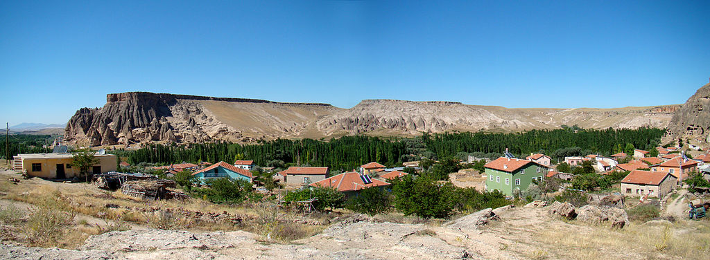
English: The Ihlara Valley (more like a canyon) opens up to a more open landscape as it comes from the east (right side of this photo) and meets the town Yaprakhisar. This view is claimed by local tour operators to have been used in a Star Wars movie, but this is not true.
What is true, though, is that in left back of the photo you see an area with many impressive caves carved out of the mountain by people through centuries. "Selime Kalesi" is the most remarkable of them, a monastery/church complex with two large courts. |
| Date | |
| Source | Own work by uploader, http://bjornfree.com/galleries.html |
| Author | Bjørn Christian Tørrissen |
| Other versions |
Derivative works of this file: |
| Camera location | | View this and other nearby images on: OpenStreetMap |
|---|
Licensing
I, the copyright holder of this work, hereby publish it under the following licenses:
This file is licensed under the Creative Commons Attribution-Share Alike 3.0 Unported license.
- You are free:
- to share – to copy, distribute and transmit the work
- to remix – to adapt the work
- Under the following conditions:
- attribution – You must give appropriate credit, provide a link to the license, and indicate if changes were made. You may do so in any reasonable manner, but not in any way that suggests the licensor endorses you or your use.
- share alike – If you remix, transform, or build upon the material, you must distribute your contributions under the same or compatible license as the original.

|
Permission is granted to copy, distribute and/or modify this document under the terms of the GNU Free Documentation License, Version 1.2 or any later version published by the Free Software Foundation; with no Invariant Sections, no Front-Cover Texts, and no Back-Cover Texts. A copy of the license is included in the section entitled GNU Free Documentation License. |
You may select the license of your choice.
File history
Click on a date/time to view the file as it appeared at that time.
| Date/Time | Thumbnail | Dimensions | User | Comment | |
|---|---|---|---|---|---|
| current | 15:23, 31 October 2009 | 6,152 × 2,260 (5.46 MB) | Uspn | {{Information |Description={{en|1=The Ihlara Valley (more like a canyon) opens up to a more open landscape as it comes from the east (right side of this photo) and meets the town Yaprakhisar. This view is claimed by local tour operators to have been used |
File usage
The following pages on the English Wikipedia use this file (pages on other projects are not listed):
Global file usage
The following other wikis use this file:
- Usage on sl.wikipedia.org