.jpg)
.jpg&action=edit&redlink=1)

Size of this preview: 480 × 600 pixels. Other resolutions: 192 × 240 pixels | 384 × 480 pixels.
Original file (800 × 1,000 pixels, file size: 177 KB, MIME type: image/jpeg)
| This is a file from the Wikimedia Commons. Information from its description page there is shown below. Commons is a freely licensed media file repository. You can help. |
.jpg)
Summary
| Description |
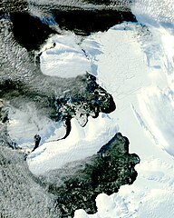
English: The MODIS instrument on NASA’s Aqua satellite captured this image. It shows that the smooth ice bridge connecting Charcot Island and Latady Island up to 31 March 2009 is gone, replaced by chunks of ice. |
| Date | |
| Source | http://earthobservatory.nasa.gov/IOTD/view.php?id=37806&src=iotdrss |
| Author | Jeff Schmaltz |
NASA image courtesy Jeff Schmaltz, MODIS Rapid Response Team at NASA GSFC.
Licensing
| This file is in the public domain in the United States because it was solely created by NASA. NASA copyright policy states that "NASA material is not protected by copyright unless noted". (See Template:PD-USGov, NASA copyright policy page or JPL Image Use Policy.) | ||
 |
Warnings:
|
File history
Click on a date/time to view the file as it appeared at that time.
| Date/Time | Thumbnail | Dimensions | User | Comment | |
|---|---|---|---|---|---|
| current | 14:07, 19 April 2009 | | 800 × 1,000 (177 KB) | Originalwana | {{Information |Description={{en|1=The MODIS instrument on NASA’s Aqua satellite captured this image. It shows that the smooth ice bridge connecting Charcot Island and Latady Island up to 31 March 2009 is gone, replaced by chunks of ice.}} |Source=http:/ |
File usage
The following pages on the English Wikipedia use this file (pages on other projects are not listed):
Global file usage
The following other wikis use this file:
- Usage on fr.wikipedia.org
- Usage on it.wikipedia.org
- Usage on nn.wikipedia.org
- Usage on pl.wikipedia.org
.jpg)