
Size of this preview: 800 × 395 pixels. Other resolutions: 320 × 158 pixels | 640 × 316 pixels | 1,024 × 505 pixels | 1,280 × 631 pixels | 2,560 × 1,263 pixels | 5,669 × 2,796 pixels.
Original file (5,669 × 2,796 pixels, file size: 11.86 MB, MIME type: image/jpeg)
| This is a file from the Wikimedia Commons. Information from its description page there is shown below. Commons is a freely licensed media file repository. You can help. |
Summary
| Description |
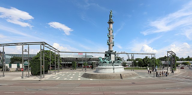
Deutsch: Die Westansicht des Pratersterns mit dem Tegetthoff-Denkmal im 2. Wiener Gemeindebezirk Leopoldstadt. Links im Hintergrund der Bahnhof Wien Praterstern und rechts hinter dem Denkmal das Riesenrad. Die Benennung Praterstern erfolgte offiziell 1879 aufgrund der damals hier sternförmig zusammenlaufenden sieben Straßen. Im Zuge des Umbaus bzw. Neubaus des Bahnhofs Wien Praterstern (zuvor Bahnhof Wien Nord) von 2004 bis 2008 erfolgte eine Neugestaltung des Praterstern; unter anderem durch die „eigenwillige“ Pergola. Das Denkmal im Vordergrund wurde zu Ehren Wilhelm von Tegetthoff errichtet und am 21. September 1886 enthüllt. |
| Date | |
| Source | Own work |
| Author | C.Stadler/Bwag |
| Permission (Reusing this file) |
Deutsch: Hallo, du darfst mein Foto kostenlos nutzen, aber nenne mich bitte als Fotograf, beispielsweise „Foto: C.Stadler/Bwag“ oder © C.Stadler/Bwag; CC-BY-SA-4.0. Auf mehr Angaben bestehe ich nicht - im Gegensatz zu manch anderen, die die Vorgaben der unten angeführten Lizenzierung auf Punkt und Beistrich einfordern. English: Feel free to use my photos, but please mention me as the author like © C.Stadler/Bwag or © C.Stadler/Bwag; CC-BY-SA-4.0 (that's good enough) and if you want send me a message: bwag@gmx.net. |
| Other versions |
|
.JPG)
| Object location | | View this and other nearby images on: OpenStreetMap |
|---|
| Camera location | | View this and other nearby images on: OpenStreetMap |
|---|
Licensing
I, the copyright holder of this work, hereby publish it under the following license:
This file is licensed under the Creative Commons Attribution-Share Alike 4.0 International license.
- You are free:
- to share – to copy, distribute and transmit the work
- to remix – to adapt the work
- Under the following conditions:
- attribution – You must give appropriate credit, provide a link to the license, and indicate if changes were made. You may do so in any reasonable manner, but not in any way that suggests the licensor endorses you or your use.
- share alike – If you remix, transform, or build upon the material, you must distribute your contributions under the same or compatible license as the original.
File history
Click on a date/time to view the file as it appeared at that time.
| Date/Time | Thumbnail | Dimensions | User | Comment | |
|---|---|---|---|---|---|
| current | 06:20, 4 June 2018 | | 5,669 × 2,796 (11.86 MB) | Bwag | {{Information |Description= {{de|1=Der Praterstern mit dem Tegetthoff-Denkmal im 2. Wiener Gemeindebezirk Leopoldstadt und rechts hinter dem Denkmal das Riesenrad.<br/>Die Benennung Praterstern erfolgte offiziell 1879 aufgrund der damals hier sternförmig zusammenlaufenden sieben Straßen. Im Zuge des Umbaus bzw. Neubaus des [[:de:Bahnhof Wien Praterstern|Bahnhofs Wien Praterstern (zuvor B... |
File usage
The following pages on the English Wikipedia use this file (pages on other projects are not listed):
Global file usage
The following other wikis use this file:
- Usage on de.wikipedia.org