
Size of this preview: 800 × 573 pixels. Other resolutions: 320 × 229 pixels | 640 × 459 pixels | 1,024 × 734 pixels | 1,280 × 917 pixels | 2,560 × 1,835 pixels | 5,510 × 3,949 pixels.
Original file (5,510 × 3,949 pixels, file size: 22.67 MB, MIME type: image/jpeg)
| This is a file from the Wikimedia Commons. Information from its description page there is shown below. Commons is a freely licensed media file repository. You can help. |
Summary
| Title |
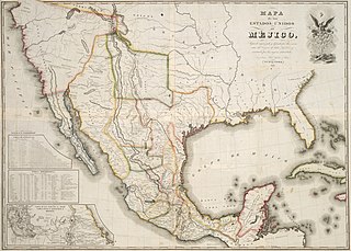
Español: Mapa de los Estados Unidos de Méjico... |
||||||||||||||||||||||||||
| Description |
English: On May 21, 1828, less than a month after the new agreement between the U.S. and Mexico, the New York publishing firm of White, Gallaher and White issued this Spanish-language map of Mexico printed by the engraving firm of Vistus Balch and Samuel Stiles. The map simply copied and translated into Spanish Henry S. Tanner's Map of the United States of Mexico, which in turn was based on the southwest portion of Tanner's Map of North America of 1822. In addition to the 1828 edition, White, Gallaher and White's map was issued again sixteen years later, in 1844, to coincide with the growing interest in Texas annexation. The next year, 1845, New York publisher John Disturnell acquired the copper plates and began issuing his own version of the map (without credit to White, Gallaher and White). Disturnell's 1847 edition of this map was later used by both sides in negotiating the 1848 Treaty of Guadalupe Hidalgo that ended the U.S. War with Mexico. |
||||||||||||||||||||||||||
| Date | |||||||||||||||||||||||||||
| Source | UTA Libraries Cartographic Connections: map / text | ||||||||||||||||||||||||||
| Creator |
|
||||||||||||||||||||||||||
| Credit line |
English: The University of Texas at Arlington Libraries Special Collections, Gift of Virginia Garrett |
||||||||||||||||||||||||||
| Geotemporal data | |||||||||||||||||||||||||||
| Map location | Mexico | ||||||||||||||||||||||||||
| Georeferencing | If inappropriate please set warp_status = skip to hide. | ||||||||||||||||||||||||||
| Bibliographic data | |||||||||||||||||||||||||||
| Place of publication | New York City | ||||||||||||||||||||||||||
| Publisher |
|
||||||||||||||||||||||||||
| Archival data | |||||||||||||||||||||||||||
| Collection |
|
||||||||||||||||||||||||||
| Dimensions | height: 75 cm (29.5 in); width: 105 cm (41.3 in) | ||||||||||||||||||||||||||
| Medium | hand-colored engraving on paper | ||||||||||||||||||||||||||
| Notes |
English: Engraved by Vistus Balch and Samuel Stiles |
||||||||||||||||||||||||||
| artwork-references |
Huseman, Ben W. (2014) The Price of Manifest Destiny: Maps Related to Wars in the Southwest, 1800-1866, Arlington: UTA Libraries Special Collections, no. 2, 3 , pp. 6–7 Wheat, Carl I. (1957–1963) Mapping the Trans-Mississippi West 1540-1861, 2, San Francisco: The Institute of Historical Cartography, no. 384 , pp. 95, 234 Martin, James C.; Robert S. Martin (1999) Maps of Texas and the Southwest, 1513-1900, Austin: Texas State Historical Association, no. 37, 38 , pp. 137–139 Jackson, Jack (October 1997). "General Taylor's 'Astonishing' Map of Northeastern Mexico". Southwestern Historical Quarterly CI (2). |
||||||||||||||||||||||||||
Licensing

|
This file was provided to Wikimedia Commons by the University of Texas at Arlington Libraries as part of a cooperation project. The University of Texas at Arlington Libraries is part of the University of Texas at Arlington, a public research university located in Arlington, Texas.
|
This work is in the public domain in the United States because it was published (or registered with the U.S. Copyright Office) before January 1, 1929.
Public domain works must be out of copyright in both the United States and in the source country of the work in order to be hosted on the Commons. If the work is not a U.S. work, the file must have an additional copyright tag indicating the copyright status in the source country.
Note: This tag should not be used for sound recordings. |
File history
Click on a date/time to view the file as it appeared at that time.
| Date/Time | Thumbnail | Dimensions | User | Comment | |
|---|---|---|---|---|---|
| current | 21:34, 6 June 2019 | | 5,510 × 3,949 (22.67 MB) | Michael Barera | == {{int:filedesc}} == {{Map |title = ''Mapa de los Estados Unidos de Méjico….'' |description = {{en|On May 21, 1828, less than a month after the new agreement between the U.S. and Mexico, the New York publishing firm of White, Gallaher and White issued this Spanish-language map of Mexico printed by the engraving firm of Vistus Balch and Samuel Stiles. The map simply copied and translated into Spanish Henry S. Tanner's ''Map of the United States of Mexico'', which in turn... |
File usage
The following pages on the English Wikipedia use this file (pages on other projects are not listed):
Global file usage
The following other wikis use this file:
- Usage on ca.wikipedia.org
- Usage on es.wikipedia.org