Size of this preview: 800 × 408 pixels. Other resolutions: 320 × 163 pixels | 640 × 327 pixels | 1,024 × 523 pixels | 1,280 × 653 pixels | 2,500 × 1,276 pixels.
Original file (2,500 × 1,276 pixels, file size: 673 KB, MIME type: image/png)
| This is a file from the Wikimedia Commons. Information from its description page there is shown below. Commons is a freely licensed media file repository. You can help. |
Summary
| Description |
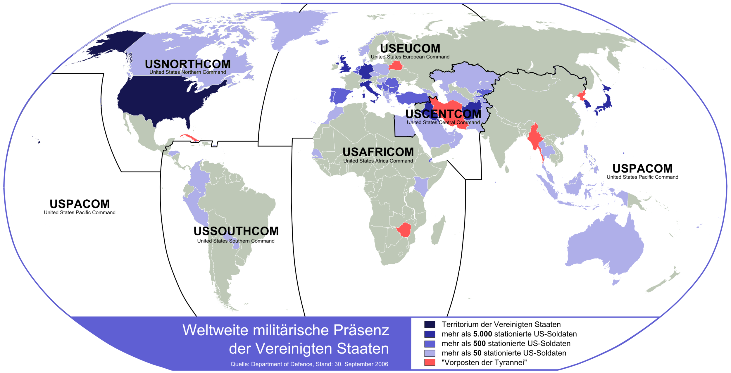
Deutsch: Weltweite militärische Präsenz der Vereinigten Staaten (Stand: 30. September 2006), die "Vorposten der Tyrannei", sowie die Grenzen der Unified Combatant Commands ab 2008 |
| Date | |
| Source |
Own work, auf Anregung dieser Karte von Benutzer:Korosaspa, neu erstellt unter Verwendung von BlankMap-World6.svg und Unified Combatant Commands map.png Quelle: Department of Defence (PDF), Stand: 30. September 2006 |
| Author | Lencer |
| Other versions |
|


|
This image could be re-created using vector graphics as an SVG file. This has several advantages; see Commons:Media for cleanup for more information. If an SVG form of this image is available, please upload it and afterwards replace this template with
{{vector version available|new image name}}.
It is recommended to name the SVG file “Weltweite militärische Präsenz der Vereinigten Staaten.svg”—then the template Vector version available (or Vva) does not need the new image name parameter. |

|
This map has been made or improved in the German Kartenwerkstatt (Map Lab). You can propose maps to improve as well.
|
Licensing
The map has been created with the Generic Mapping Tools: https://www.generic-mapping-tools.org/ using one or more of these public-domain datasets for the relief:
|

|
Permission is granted to copy, distribute and/or modify this document under the terms of the GNU Free Documentation License, Version 1.2 or any later version published by the Free Software Foundation; with no Invariant Sections, no Front-Cover Texts, and no Back-Cover Texts. A copy of the license is included in the section entitled GNU Free Documentation License. |
| This file is licensed under the Creative Commons Attribution-Share Alike 3.0 Unported license. | ||
| ||
| This licensing tag was added to this file as part of the GFDL licensing update. |
File history
Click on a date/time to view the file as it appeared at that time.
| Date/Time | Thumbnail | Dimensions | User | Comment | |
|---|---|---|---|---|---|
| current | 15:50, 6 May 2009 | | 2,500 × 1,276 (673 KB) | Noclador | update da die alte Karte Fehler enthielt: z.B. in China gibt es keine US Soldaten - jene die sich dort befinden sind Botschaftsangehörige (Attaches, bzw. Marines die die Botschaft bewachen) und z.B. betreiben die USA Luftwaffenstützpunkte in Bulgarien ( |
| 15:24, 2 October 2007 |  | 2,500 × 1,276 (697 KB) | Lencer | ||
| 16:38, 19 September 2007 |  | 1,500 × 769 (264 KB) | Lencer | ||
| 15:43, 18 September 2007 |  | 1,500 × 765 (258 KB) | Lencer | <span style="color:#FF0000; font-size:medium; font-weight:bold; text-decoration:blink;">Dies ist noch nicht die fertige Version, daher bitte nicht in Artikeln benutzen!<br />That's not the final version, please don't use in articles!</span> {{Information |
File usage
No pages on the English Wikipedia use this file (pages on other projects are not listed).
Global file usage
The following other wikis use this file:
- Usage on de.wikipedia.org
- Usage on fy.wikipedia.org