
Size of this preview: 664 × 600 pixels. Other resolutions: 266 × 240 pixels | 531 × 480 pixels | 850 × 768 pixels | 1,134 × 1,024 pixels | 1,500 × 1,355 pixels.
Original file (1,500 × 1,355 pixels, file size: 573 KB, MIME type: image/jpeg)
| This is a file from the Wikimedia Commons. Information from its description page there is shown below. Commons is a freely licensed media file repository. You can help. |
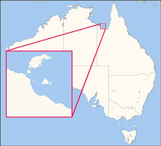
| Description | This map shows the location of the Wellesley Islands |
| Date | (UTC) |
| Source | |
| Author |
|
| Other versions | File:Locator map of Mornington Island.jpg |

|
This locator map image could be re-created using vector graphics as an SVG file. This has several advantages; see Commons:Media for cleanup for more information. If an SVG form of this image is available, please upload it and afterwards replace this template with
{{vector version available|new image name}}.
It is recommended to name the SVG file “Wellesley Islands locator map.svg”—then the template Vector version available (or Vva) does not need the new image name parameter. |


| This is a retouched picture, which means that it has been digitally altered from its original version. Modifications: Creation of locator map based on Satellite picture File:Mornington island.jpg for the Wellesley Islands, and File:Australia Locator Map.svg for Australia. The original can be viewed here: Australia Locator Map.svg:
|
I, the copyright holder of this work, hereby publish it under the following license:
| This file is licensed under the Creative Commons Attribution-Share Alike 3.0 Unported license. Subject to disclaimers. | ||
| ||
| This licensing tag was added to this file as part of the GFDL licensing update. |

|
Permission is granted to copy, distribute and/or modify this document under the terms of the GNU Free Documentation License, Version 1.2 or any later version published by the Free Software Foundation; with no Invariant Sections, no Front-Cover Texts, and no Back-Cover Texts. A copy of the license is included in the section entitled GNU Free Documentation License. Subject to disclaimers. |
Original upload log
This image is a derivative work of the following images:
- File:Australia_Locator_Map.svg licensed with GFDL-en
- 2005-12-19T21:42:45Z Boticario 290x262 (68813 Bytes) == Summary == This map image was created by Wikipedia user [[:en:User:Papayoung|Papayoung]], based on the public-domain data available through the [http://stellwagen.er.usgs.gov/mapit/ Map-It] interface.
Uploaded with derivativeFX
File history
Click on a date/time to view the file as it appeared at that time.
| Date/Time | Thumbnail | Dimensions | User | Comment | |
|---|---|---|---|---|---|
| current | 08:17, 14 May 2009 | | 1,500 × 1,355 (573 KB) | Teofilo | {{Information |Description=This map shows the location of the Wellesley Islands |Source=*File:Mornington island.jpg and File:Australia_Locator_Map.svg |Date=2009-05-14 09:10 (UTC) |Author=*File:Australia_Locator_Map.svg: was created by Wi |
File usage
The following pages on the English Wikipedia use this file (pages on other projects are not listed):
Global file usage
The following other wikis use this file:
- Usage on ast.wikipedia.org
- Usage on ca.wikipedia.org
- Usage on ceb.wikipedia.org
- Usage on da.wikipedia.org
- Usage on de.wikipedia.org
- Usage on eo.wikipedia.org
- Usage on es.wikipedia.org
- Usage on fi.wikipedia.org
- Usage on fr.wikipedia.org
- Usage on gl.wikipedia.org
- Usage on it.wikipedia.org
- Usage on ja.wikipedia.org
- Usage on ka.wikipedia.org
- Usage on ko.wikipedia.org
- Usage on pt.wikipedia.org
- Usage on sv.wikipedia.org
- Usage on www.wikidata.org
- Usage on zh-yue.wikipedia.org