No higher resolution available.
Watchingwellhalt_old_station.jpg (640 × 421 pixels, file size: 112 KB, MIME type: image/jpeg)
| This is a file from the Wikimedia Commons. Information from its description page there is shown below. Commons is a freely licensed media file repository. You can help. |
Summary
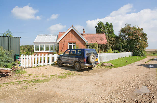
| Description |
English: Private house named Watchingwell Station, 3 km from Calbourne, Isle of Wight, near England. Marked on the map as "The Old Halt" this bungalow is where there used to be Watchingwell Halt on the now dismantled Freshwater, Yarmouth and Newport Railway line. It is in the middle of nowhere and only served a few isolated houses. Contrary to the impression created by the white palings, the railway line actually ran left to right beyond this bungalow. |
| Date | |
| Source | From geograph.org.uk |
| Author | Peter Facey |
| Permission (Reusing this file) |
Creative Commons Attribution Share-alike license 2.0 |
| Attribution (required by the license) | Peter Facey / Private house named Watchingwell Station / |
| Camera location | | View this and other nearby images on: OpenStreetMap |
|---|
_heading:22.00&language=en)
| Object location | | View this and other nearby images on: OpenStreetMap |
|---|
_heading:22.00&language=en)
Licensing

|
This image was taken from the Geograph project collection. See this photograph's page on the Geograph website for the photographer's contact details. The copyright on this image is owned by Peter Facey and is licensed for reuse under the Creative Commons Attribution-ShareAlike 2.0 license.
|
This file is licensed under the Creative Commons Attribution-Share Alike 2.0 Generic license.
Attribution: Peter Facey
- You are free:
- to share – to copy, distribute and transmit the work
- to remix – to adapt the work
- Under the following conditions:
- attribution – You must give appropriate credit, provide a link to the license, and indicate if changes were made. You may do so in any reasonable manner, but not in any way that suggests the licensor endorses you or your use.
- share alike – If you remix, transform, or build upon the material, you must distribute your contributions under the same or compatible license as the original.
Original upload log
The original description page was here. All following user names refer to en.wikipedia.
- 2007-10-21 20:29 Bashereyre 640×421× (115007 bytes) Taken by Graham Horn, June 2005- photo released onto "Photograph every grid square" via Creative Commons.
File history
Click on a date/time to view the file as it appeared at that time.
| Date/Time | Thumbnail | Dimensions | User | Comment | |
|---|---|---|---|---|---|
| current | 21:13, 26 June 2009 | | 640 × 421 (112 KB) | File Upload Bot (Magnus Manske) | {{BotMoveToCommons|en.wikipedia|year={{subst:CURRENTYEAR}}|month={{subst:CURRENTMONTHNAME}}|day={{subst:CURRENTDAY}}}} {{Information |Description={{en|Taken by Graham Horn, June 2005- photo released onto "Photograph every grid square" via Creative Common |
File usage
The following pages on the English Wikipedia use this file (pages on other projects are not listed):
Global file usage
The following other wikis use this file:
- Usage on www.wikidata.org