
Size of this PNG preview of this SVG file: 475 × 600 pixels. Other resolutions: 190 × 240 pixels | 380 × 480 pixels | 608 × 768 pixels | 811 × 1,024 pixels | 1,622 × 2,048 pixels | 815 × 1,029 pixels.
Original file (SVG file, nominally 815 × 1,029 pixels, file size: 227 KB)
| This is a file from the Wikimedia Commons. Information from its description page there is shown below. Commons is a freely licensed media file repository. You can help. |
Summary
| Description |
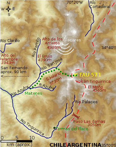
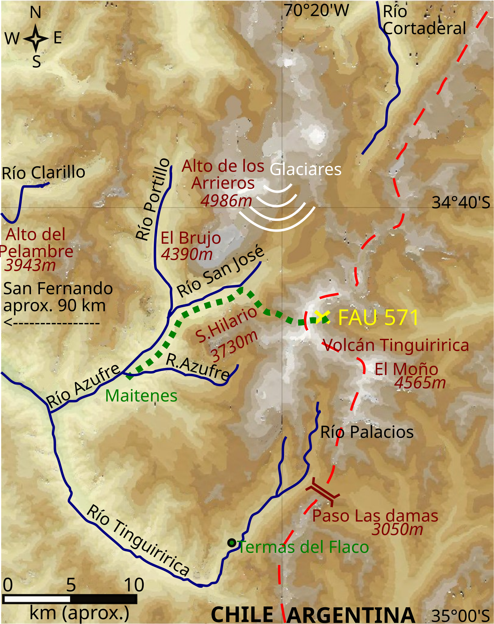
English: Zone volcan tinguiririca, termas del flaco, rio tinguiririca, FAU 571 accident. Data from:
Español: Mapa del lugar del accidente del FAU 571, donde se muestra el camino recorrido a pie por los sobrevivientes Fernando Parrado y Roberto Canessa. |
| Date | |
| Source | Own work |
| Author | Createaccount |
| Other versions |
[]
|

Template:GMT, Inkscape
Licensing
I, the copyright holder of this work, hereby publish it under the following license:
This file is licensed under the Creative Commons Attribution-Share Alike 3.0 Unported license.
- You are free:
- to share – to copy, distribute and transmit the work
- to remix – to adapt the work
- Under the following conditions:
- attribution – You must give appropriate credit, provide a link to the license, and indicate if changes were made. You may do so in any reasonable manner, but not in any way that suggests the licensor endorses you or your use.
- share alike – If you remix, transform, or build upon the material, you must distribute your contributions under the same or compatible license as the original.
File history
Click on a date/time to view the file as it appeared at that time.
| Date/Time | Thumbnail | Dimensions | User | Comment | |
|---|---|---|---|---|---|
| current | 12:22, 1 November 2012 | | 815 × 1,029 (227 KB) | Keysanger | saved and uploaded |
| 12:14, 1 November 2012 |  | 815 × 1,029 (227 KB) | Keysanger | back to vectors drawings, "ghost path" right below deleted | |
| 06:40, 10 July 2012 |  | 680 × 858 (1.18 MB) | Roger491127~commonswiki | =={{int:license-header}}== {{self|cc-by-sa-3.0}} Category:Uploaded with UploadWizard Category:Maps of rivers of Chile Category:Disasters and accidents in Chile Category:Volcanoes of Chile Category:Maps of O'Higgins Region correcte... | |
| 15:24, 23 June 2012 |  | 815 × 1,029 (228 KB) | Keysanger |
File usage
The following pages on the English Wikipedia use this file (pages on other projects are not listed):
Global file usage
The following other wikis use this file:
- Usage on ar.wikipedia.org
- Usage on ca.wikipedia.org
- Usage on de.wikipedia.org
- Usage on es.wikipedia.org
- Usage on fa.wikipedia.org
- Usage on fr.wikipedia.org
- Usage on he.wikipedia.org
- Usage on it.wikipedia.org
- Usage on pl.wikipedia.org
- Usage on pt.wikipedia.org
- Usage on ru.wikipedia.org
- Usage on uk.wikipedia.org
- Usage on uz.wikipedia.org