No higher resolution available.
Viedma_volcanic_complex.jpg (640 × 422 pixels, file size: 64 KB, MIME type: image/jpeg)
| This is a file from the Wikimedia Commons. Information from its description page there is shown below. Commons is a freely licensed media file repository. You can help. |
Summary
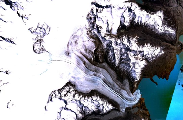
| Description |
English: The figure-8-shaped area rising above the Patagonian Icefield at the upper left part of this NASA Landsat mosaic is part of the Viedma volcanic complex. An outflow glacier descends into Lake Viedma at the lower right. This mostly subglacial volcano produced an eruption in 1988 that confirmed the presence of a postulated subglacial vent in the Patagonian Icefield NW of Viedma Lake. The 1988 eruption deposited ash and pumice on the icecap and produced a mudflow that reached Viedma Lake. |
| Date | Unknown date |
| Source | http://www.volcano.si.edu/world/volcano.cfm?vnum=1508-061&volpage=photos&photo=115011 |
| Author | NASA Landsat7 image (worldwind.arc.nasa.gov) |
Licensing
| This image is in the public domain because it is a screenshot from NASA’s globe software World Wind using a public domain layer, such as Blue Marble, MODIS, Landsat, SRTM, USGS or GLOBE.
|
 |
File history
Click on a date/time to view the file as it appeared at that time.
| Date/Time | Thumbnail | Dimensions | User | Comment | |
|---|---|---|---|---|---|
| current | 15:37, 15 October 2010 | | 640 × 422 (64 KB) | Michael Metzger | {{Information |Description={{en|1= The figure-8-shaped area rising above the Patagonian Icefield at the upper left part of this NASA Landsat mosaic is part of the Viedma volcanic complex. An outflow glacier descends into Lake Viedma at the lower right. Th |
File usage
The following pages on the English Wikipedia use this file (pages on other projects are not listed):
Global file usage
The following other wikis use this file:
- Usage on arz.wikipedia.org
- Usage on cs.wikipedia.org
- Usage on de.wikipedia.org
- Usage on es.wikipedia.org
- Usage on fr.wikipedia.org
- Usage on pt.wikipedia.org
- Usage on sk.wikipedia.org
- Usage on uk.wikipedia.org
- Usage on www.wikidata.org