
Size of this preview: 800 × 560 pixels. Other resolutions: 320 × 224 pixels | 640 × 448 pixels | 1,094 × 766 pixels.
Original file (1,094 × 766 pixels, file size: 821 KB, MIME type: image/png)
Summary edit
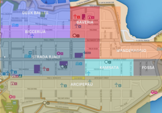
A map of Valletta showing the estimated boundaries of it's neighborhoods. Source is from the university of Malta under creative comments.
Licensing edit
I, the copyright holder of this work, hereby publish it under the following license:
| This work is licensed under the Creative Commons Attribution 4.0 License. |
File history
Click on a date/time to view the file as it appeared at that time.
| Date/Time | Thumbnail | Dimensions | User | Comment | |
|---|---|---|---|---|---|
| current | 22:00, 6 January 2023 | | 1,094 × 766 (821 KB) | Pichemist (talk | contribs) | A map of Valletta showing the estimated boundaries of it's neighborhoods. Source is from the university of Malta under creative comments. |
You cannot overwrite this file.
File usage
The following pages on the English Wikipedia use this file (pages on other projects are not listed):