
Size of this preview: 800 × 537 pixels. Other resolutions: 320 × 215 pixels | 640 × 429 pixels | 1,024 × 687 pixels | 1,280 × 859 pixels | 2,271 × 1,524 pixels.
Original file (2,271 × 1,524 pixels, file size: 2.6 MB, MIME type: image/png)
| This is a file from the Wikimedia Commons. Information from its description page there is shown below. Commons is a freely licensed media file repository. You can help. |
Summary
| Description |
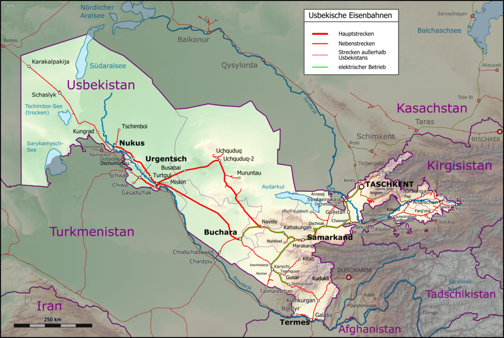
English: Map of Uzbek Railways network. Caption in German Deutsch: Karte des Streckennetzes der Usbekischen Eisenbahnen. |
|||||||||
| Date | ||||||||||
| Source |
Map was created using:
|
|||||||||
| Creator |
|
|||||||||
| Permission (Reusing this file) |
Map data (c) OpenStreetMap (and) contributors, CC-BY-SA | |||||||||
| Geotemporal data | ||||||||||
| Bounding box |
|
|||||||||
| Georeferencing | ||||||||||
Licensing
I, the copyright holder of this work, hereby publish it under the following license:
This file is licensed under the Creative Commons Attribution-Share Alike 3.0 Unported license.
- You are free:
- to share – to copy, distribute and transmit the work
- to remix – to adapt the work
- Under the following conditions:
- attribution – You must give appropriate credit, provide a link to the license, and indicate if changes were made. You may do so in any reasonable manner, but not in any way that suggests the licensor endorses you or your use.
- share alike – If you remix, transform, or build upon the material, you must distribute your contributions under the same or compatible license as the original.
| This work is licensed under the Open Database License (summary). |
| Annotations | This image is annotated: View the annotations at Commons |
File history
Click on a date/time to view the file as it appeared at that time.
| Date/Time | Thumbnail | Dimensions | User | Comment | |
|---|---|---|---|---|---|
| current | 22:43, 3 December 2022 | | 2,271 × 1,524 (2.6 MB) | Pechristener | Bukhara-Miskin-Urgench-Khiva updated |
| 21:16, 7 September 2017 |  | 2,422 × 1,626 (2.05 MB) | Pechristener | Elektrifizierte Abschnitte nachgeführt. | |
| 17:00, 7 July 2016 |  | 2,422 × 1,626 (2.04 MB) | Pechristener | Balchaschsee durch Aydarkul ersetzt. | |
| 05:54, 3 July 2016 |  | 2,422 × 1,626 (2.04 MB) | Pechristener | try to fix some rendering issues | |
| 05:14, 3 July 2016 |  | 2,422 × 1,626 (2.04 MB) | Pechristener | Angren-Pap railway eröffnet | |
| 18:40, 1 September 2015 |  | 2,098 × 1,408 (1.58 MB) | Kopiersperre | optipng | |
| 02:29, 4 April 2015 |  | 2,098 × 1,408 (1.81 MB) | Pechristener | {{Information |Description = {{en|Map of Uzbek Railways network. Caption in German}}{{de|Karte des Streckennetzes der Usbekischen Eisenbahnen.}} |Source=Map was created using: * [http://www.... |
File usage
The following pages on the English Wikipedia use this file (pages on other projects are not listed):
Global file usage
The following other wikis use this file:
- Usage on de.wikipedia.org
- Usage on es.wikipedia.org
- Usage on ja.wikipedia.org
- Usage on ml.wikipedia.org
- Usage on pl.wikipedia.org
- Usage on ru.wikipedia.org
- Usage on tr.wikipedia.org
- Usage on uz.wikipedia.org
- Usage on vi.wikipedia.org
- Usage on www.wikidata.org