Size of this preview: 800 × 418 pixels. Other resolutions: 320 × 167 pixels | 640 × 335 pixels | 1,425 × 745 pixels.
Original file (1,425 × 745 pixels, file size: 52 KB, MIME type: image/png)
| This is a file from the Wikimedia Commons. Information from its description page there is shown below. Commons is a freely licensed media file repository. You can help. |
Summary
| Description |
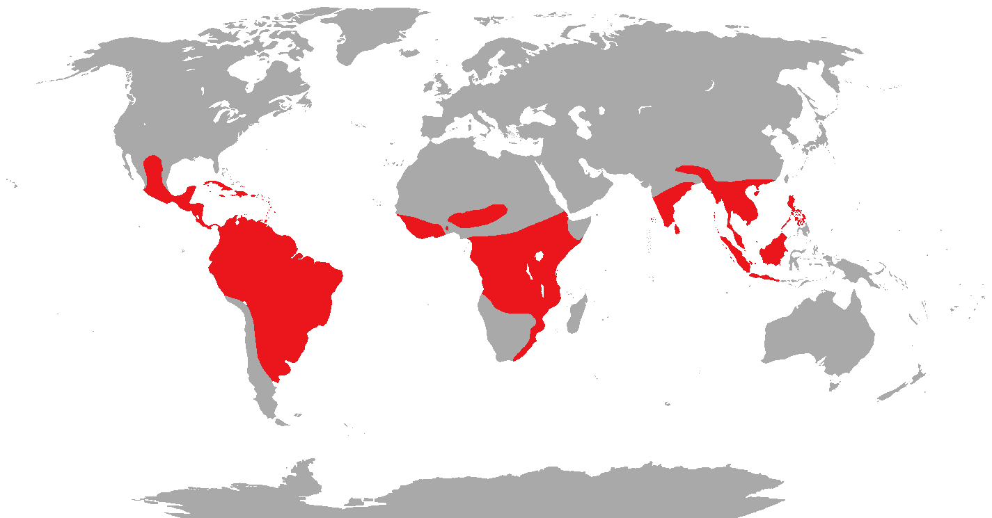
English: Map showing the range of the Trogons. |
| Date | 21 November 2011 (original upload date) |
| Source |
Own Work, based on maps and information from Birds, A visual guide by Joanna Burger, (Page 150). Transferred from en.wikipedia |
| Author | Phoenix_B_1of3 (talk) (Uploads) |
Licensing
Phoenix B 1of3 at en.wikipedia, the copyright holder of this work, hereby publishes it under the following license:
| This file is made available under the Creative Commons CC0 1.0 Universal Public Domain Dedication. | |
| The person who associated a work with this deed has dedicated the work to the public domain by waiving all of their rights to the work worldwide under copyright law, including all related and neighboring rights, to the extent allowed by law. You can copy, modify, distribute and perform the work, even for commercial purposes, all without asking permission.
|
Original upload log
The original description page was here. All following user names refer to en.wikipedia.
- 2011-11-21 17:42 Phoenix B 1of3 1425×745 (51811 bytes) Not Done Yet
- 2011-11-21 17:47 Phoenix B 1of3 1425×745 (52923 bytes) Almost Done
- 2011-11-21 17:52 Phoenix B 1of3 1425×745 (52922 bytes) Final Touches
- 2011-11-22 00:58 Phoenix B 1of3 1425×745 (52976 bytes) Remove Madagascar
- 2011-11-22 01:09 Phoenix B 1of3 1425×745 (52922 bytes) Narrow North American Range
- 2011-11-22 01:11 Phoenix B 1of3 1425×745 (52915 bytes) oops
File history
Click on a date/time to view the file as it appeared at that time.
| Date/Time | Thumbnail | Dimensions | User | Comment | |
|---|---|---|---|---|---|
| current | 03:29, 26 February 2012 | | 1,425 × 745 (52 KB) | OgreBot | (BOT): Reverting to most recent version before archival |
| 03:29, 26 February 2012 |  | 1,425 × 745 (52 KB) | OgreBot | (BOT): Uploading old version of file from en.wikipedia; originally uploaded on 2011-11-22 00:58:03 by Phoenix B 1of3 | |
| 03:29, 26 February 2012 |  | 1,425 × 745 (52 KB) | OgreBot | (BOT): Uploading old version of file from en.wikipedia; originally uploaded on 2011-11-21 17:52:33 by Phoenix B 1of3 | |
| 03:29, 26 February 2012 |  | 1,425 × 745 (52 KB) | OgreBot | (BOT): Uploading old version of file from en.wikipedia; originally uploaded on 2011-11-21 17:47:17 by Phoenix B 1of3 | |
| 03:29, 26 February 2012 |  | 1,425 × 745 (51 KB) | OgreBot | (BOT): Uploading old version of file from en.wikipedia; originally uploaded on 2011-11-21 17:42:44 by Phoenix B 1of3 | |
| 16:43, 24 February 2012 |  | 1,425 × 745 (52 KB) | MGA73bot2 | == {{int:filedesc}} == {{Information |description={{en|1=Map showing the range of the Trogons.}} |date={{Date|2011|11|21}} (original upload date) |source=Own Work, based on maps and information from '''''Birds, A visual guide''''' by Joanna Burger, (Pa... |
File usage
The following pages on the English Wikipedia use this file (pages on other projects are not listed):
Global file usage
The following other wikis use this file:
- Usage on ar.wikipedia.org
- Usage on arz.wikipedia.org
- Usage on ast.wikipedia.org
- Usage on bg.wikipedia.org
- Usage on ca.wikipedia.org
- Usage on cs.wikipedia.org
- Usage on de.wikipedia.org
- Usage on eo.wikipedia.org
- Usage on eu.wikipedia.org
- Usage on fi.wikipedia.org
- Usage on gl.wikipedia.org
- Usage on he.wikipedia.org
- Usage on hr.wikipedia.org
- Usage on hu.wikipedia.org
- Usage on id.wikipedia.org
- Usage on ja.wikipedia.org
- Usage on ka.wikipedia.org
- Usage on ko.wikipedia.org
- Usage on la.wikipedia.org
- Usage on ml.wikipedia.org
- Usage on mrj.wikipedia.org
- Usage on my.wikipedia.org
- Usage on nn.wikipedia.org
- Usage on pl.wikipedia.org
- Usage on pnb.wikipedia.org
- Usage on pt.wikipedia.org
- Usage on simple.wikipedia.org
- Usage on sr.wikipedia.org
- Usage on sv.wikipedia.org
- Usage on ta.wikipedia.org
- Usage on tr.wikipedia.org
- Usage on vi.wikipedia.org
- Usage on www.wikidata.org
- Usage on zh.wikipedia.org