Size of this preview: 420 × 599 pixels. Other resolutions: 168 × 240 pixels | 600 × 856 pixels.
Original file (600 × 856 pixels, file size: 32 KB, MIME type: image/png)
| This is a file from the Wikimedia Commons. Information from its description page there is shown below. Commons is a freely licensed media file repository. You can help. |

|
This file was moved to Wikimedia Commons from en.wikipedia using a bot script. All source information is still present. It requires review. Additionally, there may be errors in any or all of the information fields; information on this file should not be considered reliable and the file should not be used until it has been reviewed and any needed corrections have been made. Once the review has been completed, this template should be removed. For details about this file, see below. Check now! |
Summary
| Description |
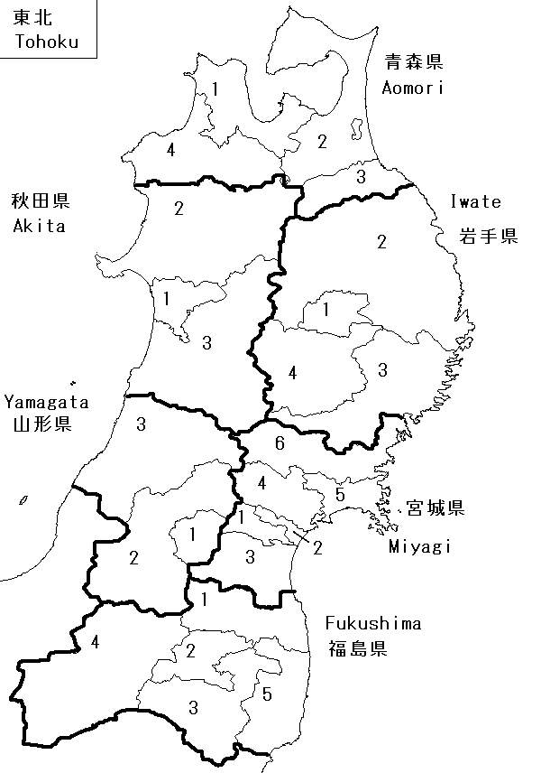
English: Map of Japanese single member House of Representatives districts as of 2005; part of a project to report detailed result for 2005 and possibly 2003 elections.
Boundary representations are not necessarily authoritative; based on :ja:衆議院小選挙区一覧 and maps by ja.wikipedia user Koba-chan. |
| Date | 23 August 2005 (original upload date) |
| Source |
Own work Transferred from en.wikipedia |
| Author | Willhsmit at en.wikipedia |
Licensing
| |
This work has been released into the public domain by its author, Willhsmit, at the English Wikipedia project. This applies worldwide. In case this is not legally possible: |
Original upload log
The original description page was here. All following user names refer to en.wikipedia.
- 2005-08-23 23:08 Willhsmit 600×856 (32443 bytes) {{PD-self}} Map of Japanese single member House of Representatives districts as of 2005; part of a project to report detailed result for 2005 and possibly 2003 elections. Boundary representations are not necessarily authoritative; based on [[ja:衆
File history
Click on a date/time to view the file as it appeared at that time.
| Date/Time | Thumbnail | Dimensions | User | Comment | |
|---|---|---|---|---|---|
| current | 13:08, 26 January 2011 | | 600 × 856 (32 KB) | MGA73bot2 | {{BotMoveToCommons|en.wikipedia|year={{subst:CURRENTYEAR}}|month={{subst:CURRENTMONTHNAME}}|day={{subst:CURRENTDAY}}}} == {{int:filedesc}} == {{Information |description={{en|1=Map of Japanese single member House of Representatives districts as of 2005; p |
File usage
No pages on the English Wikipedia use this file (pages on other projects are not listed).