
Size of this PNG preview of this SVG file: 555 × 599 pixels. Other resolutions: 222 × 240 pixels | 444 × 480 pixels | 711 × 768 pixels | 948 × 1,024 pixels | 1,896 × 2,048 pixels | 1,910 × 2,063 pixels.
Original file (SVG file, nominally 1,910 × 2,063 pixels, file size: 783 KB)
| This is a file from the Wikimedia Commons. Information from its description page there is shown below. Commons is a freely licensed media file repository. You can help. |
Summary
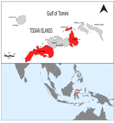
| Description | Togian Islands location map |
| Date | |
| Source | Own work |
| Author | L. Shyamal |
| Permission (Reusing this file) |
pd |
This W3C-unspecified vector image was created with Inkscape .
Licensing
| I, the copyright holder of this work, release this work into the public domain. This applies worldwide. In some countries this may not be legally possible; if so: I grant anyone the right to use this work for any purpose, without any conditions, unless such conditions are required by law. |
File history
Click on a date/time to view the file as it appeared at that time.
| Date/Time | Thumbnail | Dimensions | User | Comment | |
|---|---|---|---|---|---|
| current | 10:14, 19 March 2008 | | 1,910 × 2,063 (783 KB) | Shyamal | Mark distribution of Zosterops somadikartai in red |
| 09:52, 19 March 2008 |  | 1,910 × 2,063 (788 KB) | Shyamal | {{Information |Description=Togian Islands location map |Source=self-made |Date=March 2008 |Author= L. Shyamal |Permission=pd |other_versions= }} |
File usage
The following pages on the English Wikipedia use this file (pages on other projects are not listed):
Global file usage
The following other wikis use this file:
- Usage on ar.wikipedia.org
- Usage on bg.wikipedia.org
- Usage on ca.wikipedia.org
- Usage on ceb.wikipedia.org
- Usage on de.wikipedia.org
- Usage on es.wikipedia.org
- Usage on eu.wikipedia.org
- Usage on fi.wikipedia.org
- Usage on fr.wikipedia.org
- Usage on hu.wikipedia.org
- Usage on id.wikipedia.org
- Usage on nl.wikipedia.org
- Usage on no.wikipedia.org
- Usage on pl.wikipedia.org
- Usage on pt.wikipedia.org
- Usage on ru.wikipedia.org
- Usage on sv.wikipedia.org
- Usage on uk.wikipedia.org
- Usage on vi.wikipedia.org
- Usage on www.wikidata.org