
Size of this PNG preview of this SVG file: 800 × 550 pixels. Other resolutions: 320 × 220 pixels | 640 × 440 pixels | 1,024 × 703 pixels | 1,280 × 879 pixels | 2,560 × 1,759 pixels | 872 × 599 pixels.
Original file (SVG file, nominally 872 × 599 pixels, file size: 155 KB)
| This is a file from the Wikimedia Commons. Information from its description page there is shown below. Commons is a freely licensed media file repository. You can help. |
Summary
| Description |
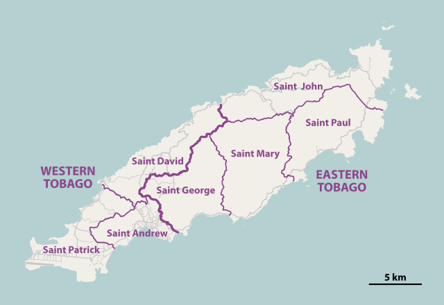
Deutsch: Karte der parishes von Tobago
English: Map of the parishes of Tobago |
||||||||||||
| Date | |||||||||||||
| Source | http://tobagoborn.com/tobago/census/tobago_introv2.html | ||||||||||||
| Author | NordNordWest | ||||||||||||
| Permission (Reusing this file) |
|
||||||||||||
| SVG development | This map was created with Adobe Illustrator by NordNordWest.
|

|
This map has been made or improved in the German Kartenwerkstatt (Map Lab). You can propose maps to improve as well.
|
File history
Click on a date/time to view the file as it appeared at that time.
| Date/Time | Thumbnail | Dimensions | User | Comment | |
|---|---|---|---|---|---|
| current | 19:40, 8 January 2011 | | 872 × 599 (155 KB) | NordNordWest | =={{int:filedesc}}== {{Information |Description= {{de|Karte der ''parishes'' von Tobago}} {{en|Map of the parishes of Tobago}} |Source=http://tobagoborn.com/tobago/census/tobago_introv2.html |Date=2011-01-08 |Author={{U|Nord |
File usage
The following pages on the English Wikipedia use this file (pages on other projects are not listed):
Global file usage
The following other wikis use this file:
- Usage on ar.wikipedia.org
- Usage on ca.wikipedia.org
- Usage on cs.wikipedia.org
- Usage on cv.wikipedia.org
- Usage on de.wikipedia.org
- Usage on es.wikipedia.org
- Usage on eu.wikipedia.org
- Usage on fa.wikipedia.org
- Usage on fi.wiktionary.org
- Usage on ga.wikipedia.org
- Usage on ha.wikipedia.org
- Usage on hr.wikipedia.org
- Usage on is.wikipedia.org
- Usage on it.wikivoyage.org
- Usage on ja.wikipedia.org
- Usage on ka.wikipedia.org
- Usage on ko.wikipedia.org
- Usage on mt.wikipedia.org
- Usage on pl.wikipedia.org
- Usage on ro.wikipedia.org
- Usage on ru.wikipedia.org
- Usage on sco.wikipedia.org
- Usage on sh.wikipedia.org
- Usage on sr.wikipedia.org
- Usage on tr.wikipedia.org
- Usage on uk.wikipedia.org
- Usage on ur.wikipedia.org
- Usage on war.wikipedia.org
- Usage on www.wikidata.org
- Usage on zh.wikipedia.org