.jpg)
.jpg&action=edit&redlink=1)
No higher resolution available.
Tidying_up,_Linburn_Road_-_geograph.org.uk_-_1360587_(cropped).jpg (182 × 235 pixels, file size: 30 KB, MIME type: image/jpeg)
| This is a file from the Wikimedia Commons. Information from its description page there is shown below. Commons is a freely licensed media file repository. You can help. |
.jpg)
Summary
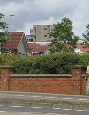
| Description |
English: The concrete tower of Lynebank Hospital, just visible over the rooftops |
| Date | |
| Source |
This file was derived from: Tidying up, Linburn Road - geograph.org.uk - 1360587.jpg |
| Author | Richard Webb |
| Permission (Reusing this file) |
This file is licensed under the Creative Commons Attribution-Share Alike 2.0 Generic license. Attribution: Richard Webb
|
| Attribution (required by the license) | Richard Webb / Tidying up, Linburn Road / |
| Camera location | | View this and other nearby images on: OpenStreetMap |
|---|
.jpg¶ms=056.075090_N_-003.417500_E_globe:Earth_type:camera_source:geograph-osgb36(NT11868782)_region:GB-GBN_heading:67.00&language=en)
| Object location | | View this and other nearby images on: OpenStreetMap |
|---|
.jpg¶ms=056.075100_N_-003.416800_E_globe:Earth_class:object_type:object_source:geograph-osgb36(NT11908782)_region:GB-GBN_heading:67.00&language=en)
| This is a retouched picture, which means that it has been digitally altered from its original version. Modifications: cropped. The original can be viewed here: Tidying up, Linburn Road - geograph.org.uk - 1360587.jpg:
|
File history
Click on a date/time to view the file as it appeared at that time.
| Date/Time | Thumbnail | Dimensions | User | Comment | |
|---|---|---|---|---|---|
| current | 00:07, 10 February 2020 | | 182 × 235 (30 KB) | Dormskirk | {{Information |description ={{en|1=Tidying up, Linburn Road}} |date =18 June 2009 |source =File:Tidying up, Linburn Road - geograph.org.uk - 1360587.jpg |author =Richard Webb |permission ={{PD-user|Richard Webb}} }} {{RetouchedPicture|cropped|editor=Dormskirk|orig=Tidying up, Linburn Road - geograph.org.uk - 1360587.jpg}} Category:Dunfermline |
File usage
The following pages on the English Wikipedia use this file (pages on other projects are not listed):
Global file usage
The following other wikis use this file:
- Usage on de.wikivoyage.org
- Usage on www.wikidata.org
.jpg)